 Yamanashi(山梨)
 Mt. Notori
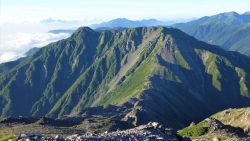
Mt. Notori (3,026 m), on the border of Hayakawa in Minamikoma, Yamanashi and Aoi Ward in Shizuoka City, is one of the 20...
New 100 Famous Japanese Mountains — we cover 72 of them, all reachable by public transport. Popular choices include Kirigamine, Mt. Adatara, Mt. Aka and Mt. Akaishi. Each guide shows the route from the nearest station to the trailhead, with up-to-date bus timetables.
New 100 Famous Japanese Mountains
No mountains match.
Yamanashi(山梨)  Nara(奈良)
  Nagano(長野)
  Oita(大分)
  Fukushima(福島)
  Kyoto
Kyoto  Shizuoka(静岡)
 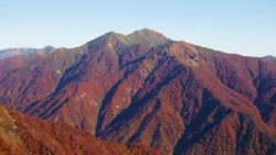 Gunma(群馬)
  Yamanashi(山梨)
  Gifu(岐阜)
  Gunma(群馬)
  Gifu(岐阜)
 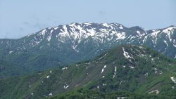 Aomori(青森)
  Kagoshima(鹿児島)
  Fukuoka
  Okayama (岡山)
  Hyogo
Hyogo  Miyagi(宮城)
  Shimane (島根)
  Shizuoka(静岡)
  Akita(秋田)
  Oita(大分)
 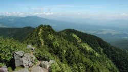 Gunma(群馬)
  Hyogo
Hyogo  Shiga(滋賀)
  Mie
Mie  Toyama(富山)
  Nagano(長野)
 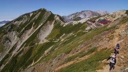 Nagano(長野)
  Nagano(長野)
  Shizuoka(静岡)
  Yamanashi(山梨)
  Nagano(長野)
  Shizuoka(静岡)
 Amagisan is a collective name for the mountain range running east-west through the center of the Izu Peninsula in Shizuoka Prefecture. The highest peak is Banzaburodake at 1,405m. *Timetable last checked: [sc name=”updated_date”][/sc] Access to the Trailhead Going: Ito Sta. → Amagi Traverse Trailhead Return: Amagi Traverse Trailhead → Ito Sta. Map & Recommended Route 1. Going: Ito Sta. → Amagi Traverse Trailhead From JR Ito Station (Platform 2), take the Tokai Bus “Amagi Tokyu Resort Shuttle Bus” to Amagi Traverse Trailhead.Travel time: Approx. 55 min Bus Timetable: Ito Sta. → Amagi Traverse Trailhead Daily service (extra buses on select dates only) Ito Sta. (Dep.) Amagi Traverse Trailhead (Arr.) Notes […]
 Nagano(長野)
  Hokkaido
  Osaka(大阪)
  Tokushima(徳島)