Mt. Dainichi (大日ヶ岳, 1,709 m), straddling Gujō and Takayama in Gifu Prefecture, is one of the 200 Famous Japanese Mountains.
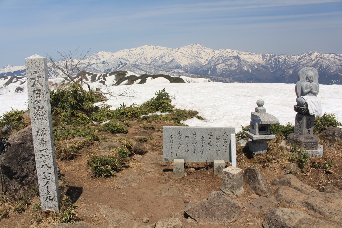
A leading peak of the Okumino region, it has a statue of Dainichi Nyorai at its summit and is known for its sweeping view of the Hakusan range. The usual route, out and back from the summit via the Hirugano Kogen course, is an intermediate course of about 7 hours 15 minutes round trip, climbing through forests of beech and oak.
The nearest station is Mino-Shirotori on the Nagaragawa Railway. From there, take the Shirotori Kotsu bus (Hirugano line) to Bunsuirei Park and walk to the trailhead.
The trailhead is the Hirugano Kogen trailhead (the “Suidōyama” trailhead, about 1,000 m elevation), with parking for about 15 cars. From the Bunsuirei Park bus stop it is about a 20-minute walk to the trailhead. The route runs trailhead → beech-and-oak forest → Ippukudaira → summit (1,709 m), about 7 hours 15 minutes round trip, intermediate. From the summit the Hakusan range spreads out right before you.
The season is late May to November (in winter it operates as a ski resort). There are 6 buses on weekdays and 4 on weekends and holidays, and on weekends/holidays the first bus is late (arriving Bunsuirei Park at 9:28) and the last return bus is early (leaving Bunsuirei Park at 16:33), so a round trip of about 7 hours is tight as a day trip. Using an early weekday bus, or staying overnight, is recommended. There are no shops on the mountain, so prepare water and food.
How to access the trailhead
1. [Outbound] Mino-Shirotori Station → Bunsuirei Park
From Mino-Ōta Station on the JR Takayama Main Line, change to the Nagaragawa Railway and get off at Mino-Shirotori Station. Take the Shirotori Kotsu bus (Hirugano line, toward Hirugano) and get off at Bunsuirei Park.
Fare: about ¥720
From the Bunsuirei Park bus stop it is about a 20-minute walk to the trailhead.
Bus TimetableMino-Shirotori Station to Bunsuirei Park (Shirotori Kotsu, Hirugano line)
| Mino-Shirotori Sta. dep. | Bunsuirei Park arr. |
|---|---|
| 6:45 | 7:23 |
| 8:50 | 9:28 |
| 11:30 | 12:08 |
| 14:30 | 15:08 |
| 16:40 | 17:18 |
| 18:30 | 19:08 |
| Mino-Shirotori Sta. dep. | Bunsuirei Park arr. |
|---|---|
| 8:50 | 9:28 |
| 11:30 | 12:08 |
| 15:30 | 16:08 |
| 18:30 | 19:08 |
Source: [Shirotori Kotsu, Hirugano line (April 2026 revision)]
2. [Return] Bunsuirei Park → Mino-Shirotori Station
After descending, take the Shirotori Kotsu bus (Hirugano line, toward Shirotori) from Bunsuirei Park and get off at Mino-Shirotori Station.
Fare: about ¥720
Allow about 20 minutes to walk from the trailhead to the Bunsuirei Park bus stop, so plan your descent with time to spare.
Bus TimetableBunsuirei Park to Mino-Shirotori Station (Shirotori Kotsu, Hirugano line)
| Bunsuirei Park dep. | Mino-Shirotori Sta. arr. |
|---|---|
| 6:48 | 7:26 |
| 7:38 | 8:16 |
| 9:48 | 10:26 |
| 12:33 | 13:11 |
| 15:33 | 16:11 |
| 17:43 | 18:21 |
| Bunsuirei Park dep. | Mino-Shirotori Sta. arr. |
|---|---|
| 6:48 | 7:26 |
| 9:48 | 10:26 |
| 12:33 | 13:11 |
| 16:33 | 17:11 |
Source: [Shirotori Kotsu, Hirugano line (April 2026 revision)]
Route and safety notes
Route: Hirugano Kogen trailhead → beech-and-oak forest → Ippukudaira → summit. About 7 hours 15 minutes round trip, intermediate. From the summit the Hakusan range opens up, and on clear days you can see as far as the Northern Alps.
Day-trip note: at about 7 hours round trip, and with a late first bus and early last return bus on weekends/holidays, a day trip is tight. Using an early weekday bus, or staying overnight on the Hirugano plateau, is the safer plan.
Gondola option: in summer there is also a route using the Takasu Snow Park gondola to climb near the summit, but always confirm the operating period on the ski resort’s official site.
Bears and gear: Asian black bears live in the area, so carry a bear bell and submit a climbing plan. Bring water, food and rain gear.
In an emergency: call 110 (police) or 119 (fire/rescue).
・Shirotori Kotsu (bus) 0575-82-5081
Photo by Alpsdake / Wikimedia Commons, CC BY-SA 4.0
Comments