Mt. Iwawaki (岩湧山) is an 897m peak in Kawachi-Nagano City, Osaka Prefecture.
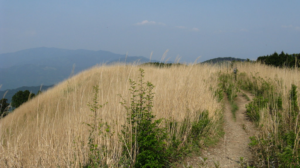
One of the New 100 Famous Japanese Mountains, the attractions are the susuki (pampas grass) grassland spreading over the entire summit and the grand view of the Osaka Plain and Osaka Bay. Katakuri flowers also bloom in spring. It is especially busy with hikers during the late-October susuki viewing season.
The popular route takes the bus from Kawachi-Nagano Station to the Takihata Dam bus stop and traverses to Kimitoge Station.
⚠ There are 2 bus routes to Takihata Dam, with different operating companies and fares (as of 2026-03-28)
- Hino / Takihata Community Bus (operated by Kawachi-Nagano City, entrusted to Nankai Bus): multiple runs on both weekdays and weekends/holidays, departing from in front of Kawachi-Nagano Station Platform 6. For fare details, please check Kawachi-Nagano City official.
- Nankai Bus Route 400 (Takamuko Line, 1 run on weekends/holidays only): in front of Kawachi-Nagano Station 8:30 → Takihata Dam Site 9:00, fare ¥510, departs from Platform 7.
* Schedule revisions were implemented on 2025-10-01 and 2026-03-28. Please always check the latest times on Nankai Bus official (2026-03-28 revised) and Kawachi-Nagano City official community bus.
Trail closure information: Mt. Iwawaki “Inishie no Michi” (around the 2nd parking lot ~ Shikisaikan stairs) remains under long-term closure due to falling rocks and fallen trees (Kawachi-Nagano City official).
When accessing Mt. Iwawaki by train and bus, the common route is to take the bus from Kawachi-Nagano Station to the Takihata Dam bus stop, then descend via Mt. Iwawaki to Kimitoge Station.
The Takihata Dam bus stop departure / arrival timetable and Mt. Iwawaki map are as follows.
*Timetable last checked: May 17, 2026
How to access the trailheads
Hiking Course Details — Mt. Iwawaki
Click to show current location.
Click for full-screen view.
*If the map does not appear, please click here.*
Map & Recommended Route — Mt. Iwawaki
1. [Outbound] Kawachi-Nagano Station → Takihata Dam
From Kawachi-Nagano Station on the Nankai Koya Line, board the Nankai Bus bound for Takihata Dam and get off at the terminus, Takihata Dam bus stop
Travel time: about 48 minutes
Fare: ¥560
Bus TimetableFrom Kawachi-Nagano Station to Takihata Dam
| Kawachi-Nagano Station | Takihata Dam |
|---|---|
| 9:04 | 9:52 |
| 11:02 | 11:50 |
| 12:30 | 13:18 |
| 13:21 | 14:09 |
| 15:21 | 16:09 |
| 16:21 | 17:06 |
| 17:17 | 18:02 |
| 18:16 | 19:04 |
| 20:00 | 20:45 |
| 21:38 | 22:23 |
Reference: [Nankai Bus official]
2. [Return] Takihata Dam → Kawachi-Nagano Station
From the Takihata Dam bus stop, board the Nankai Bus bound for Kawachi-Nagano Station and get off at the terminus.
Travel time: about 48 minutes
Fare: ¥560
Bus TimetableFrom Takihata Dam to Kawachi-Nagano Station
| Takihata Dam | Kawachi-Nagano Station |
|---|---|
| 6:02 | 6:47 |
| 6:43 | 7:28 |
| 7:27 | 8:12 |
| 8:07 | 8:52 |
| 10:03 | 10:51 |
| 12:00 | 12:48 |
| 13:25 | 14:13 |
| 14:19 | 15:07 |
| 16:19 | 17:07 |
| 17:13 | 17:58 |
| 19:08 | 19:53 |
Reference: [Nankai Bus official]
Photo bywikipedia