
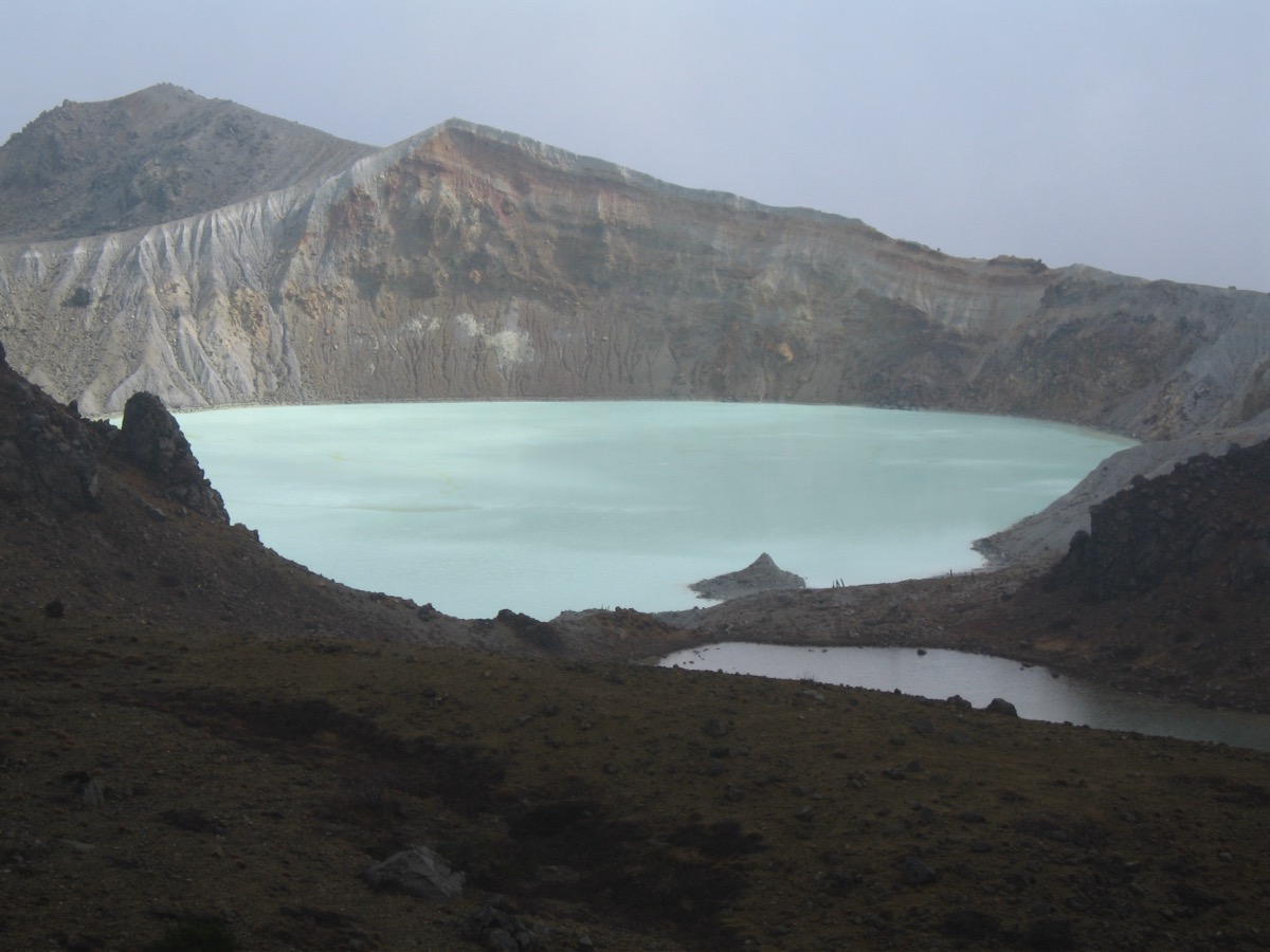
Mt. Kusatsu-Shirane (2,160 m) is an active volcano on the Gunma/Nagano prefectural border, one of the 100 Famous Mountains of Japan. The emerald-green Yugama crater lake is its iconic feature.
Access to Trailhead
- [Outbound] Nagano Station → Shibu Pass → Mt. Yokote-yama (alternative, beginner)
- [Outbound] Tokyo → Kusatsu Onsen → Yoshigadaira Wetlands (alternative hike)
Course Time
Mt. Yokote-yama (Shibu Pass start, round trip): ~1h 30min / 2km / +150m / beginner
Yoshigadaira Wetlands (Sesshōgahara start, round trip): ~6h / 10km / +530m / intermediate
1. [Outbound] Nagano Station → Shibu Pass → Mt. Yokote-yama (alternative, beginner)
Mt. Yokote-yama (2,307m, highest peak in Shiga Kogen) is the top alternative on the north side of Kusatsu-Shirane. From Shibu Pass (2,152m, highest point on Route 292), 40 min walk reaches the summit; the iconic Yokote-yama-chō Hut “Inn Above the Clouds” is famous.
Service period: Naga-Den Bus year-round / Route 292 late April – mid November (winter closure)
Travel time: Nagano Stn → Hasuike ~1h 10min, Hasuike → Shibu Pass ~40min by taxi
Fare: Nagano Stn → Hasuike ¥2,000, Hasuike → Shibu Pass taxi ~¥7,000
Reservation: Yokote-yama-chō Hut 0269-34-2430 (open late April – early November)
Reference: Yokote-yama-chō Hut
2. [Outbound] Tokyo → Kusatsu Onsen → Yoshigadaira Wetlands (alternative hike)
Yoshigadaira Wetlands (1,830m) is a Ramsar Convention site on the east slope of Kusatsu-Shirane. From Kusatsu Onsen, taxi to Sesshōgahara trailhead, then 1h 30min hiking trail to the wetlands. Strict no-entry toward Yugama / Mt. Hon-Shirane direction.
Service period: JR/bus year-round / Sesshōgahara typically May-October
Travel time: Ueno → Nagano-hara-Kusatsu-guchi ltd. exp. ~2h 30min, → Kusatsu Onsen JR bus ~25min, → Sesshōgahara taxi ~15min
Fare: Ueno → Nagano-hara-Kusatsu-guchi ¥4,820, → Kusatsu Onsen ¥710, → Sesshōgahara ¥3,000 (taxi one-way)
Reservation: Yoshigadaira Hut 0279-88-7585 (open May-October, ~¥6,500 self-catering)
Bus TimetableNagano-hara-Kusatsu-guchi Stn → Kusatsu Onsen BT (JR Bus Kanto Kusatsu Kogen Line)
| Nagano-hara-Kusatsu-guchi dep. | Kusatsu Onsen BT arr. |
|---|---|
| 7:54 | 8:19 |
| 8:54 | 9:19 |
| 10:26 | 10:51 |
| 11:31 | 11:56 |
| 12:31 | 12:56 |
| 13:26 | 13:51 |
| 14:25 | 14:53 |
| 15:32 | 15:57 |
| 16:54 | 17:19 |
| 17:40 | 18:08 |
Bus TimetableKusatsu Onsen BT → Nagano-hara-Kusatsu-guchi Stn (return)
| Kusatsu Onsen BT dep. | Nagano-hara-Kusatsu-guchi arr. |
|---|---|
| 6:20 | 6:45 |
| 6:50 | 7:15 |
| 11:00 | 11:25 |
| 13:20 | 13:45 |
| 14:40 | 15:05 |
| 15:50 | 16:15 |
| 17:00 | 17:25 |
| 18:35 | 19:00 |
Reference: JR Bus Kanto Kusatsu Kogen Line | Yoshigadaira Hut
3. Regulations & Emergency Info
Regulations
– Mt. Hon-Shirane trails: closed (fines up to ¥100,000)
– Route 292 (toward Yugama) Kusatsu side: closed, reopening TBD
– Volcanic alert level: 1 (lowered May 15, 2026; 500m around Yugama crater still no-entry)
Emergency Contacts
– Kusatsu Town Office (hiking/regulations): 0279-88-0001
– Nakanojō Police (mountain rescue): 0279-75-4110
– JMA Volcano Watch: Mt. Kusatsu-Shirane (Hon-Shirane)
Recommended Plan
– Day trip Yokote-yama: Nagano Stn 9:00 → Hasuike 10:10 → taxi Shibu Pass 11:00 → Yokote-yama round trip 1h 30min → 13:00 Hasuike → Nagano Stn. Lunch at Yokote-yama-chō Hut recommended
– Overnight (Yokote + Yoshigadaira): Day 1 Kusatsu Onsen + Yubatake, Day 2 Yokote-yama-chō Hut, Day 3 Yoshigadaira Wetlands → Kusatsu Onsen
Reference: Gunma Prefecture Kusatsu-Shirane Info
Photo by Duke Yuin
Comments