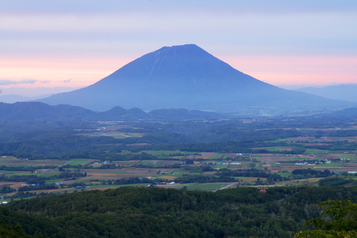
Mt. Yōtei (羊蹄山, 1,898 m) is an independent stratovolcano straddling Kutchan, Kyōgoku, Kimobetsu, and Makkari Village in Hokkaido. Also known as Shiribeshi-yama (後方羊蹄山, the name used by Kyūya Fukada in his “100 Famous Mountains of Japan”) and Ezo-Fuji (蝦夷富士), it sits within Shikotsu-Tōya National Park and is counted among the 100 Famous Mountains of Japan.
Its perfect cone, often compared to Mt. Fuji, holds a large summit crater (Chichigama) about 700 m in diameter, with snow lingering on its inner walls even in summer. The mountain offers a circumambulation of the crater rim (Ohachi-meguri, about 1 hour), more than 130 species of alpine plants, and sweeping views of the Niseko range and the Sea of Japan. However, with about 1,710 m of elevation gain from any trailhead and 9–10 hours round trip, it is firmly a mountain for intermediate-to-advanced hikers. All four routes (Hirafu, Makkari, Kyōgoku, Kimobetsu) are full-day or one-night hikes.
How to access the trailheads
- [Outbound] Kutchan Station → Hirafu Course Trailhead (JR Hirafu Station on foot / taxi)
- [Round trip] Kutchan Station ⇔ Yōtei Shizen Kōen Iriguchi (Makkari Course, Donan Bus)
- Kyōgoku and Kimobetsu Courses (car only, no public transport)
Standard times (Hirafu Course from Hangetsu-ko Campsite, round trip, ~1,700 m gain, ~12 km, ~9 hours, intermediate–advanced)
Hangetsu-ko Campsite (trailhead, 320 m) → (1 hr) → 2nd Station → (2 hr) → 5th Station → (1 hr 30 min) → 8th Station → (30 min) → 9th Station (rim / hut junction) → (20 min) → Summit (1,898 m) → Crater rim circuit (~1 hour, optional) → (3 hr 30 min) → Hangetsu-ko Campsite (descent)
Standard times (Makkari Course from Yōtei Shizen Kōen, longest of the four, gentlest gradient, ~10 hours, intermediate)
Yōtei Shizen Kōen (trailhead) → (1 hr 30 min) → 2nd Station → (2 hr) → 5th Station → (1 hr 30 min) → 8th Station → (30 min) → 9th Station (hut) → (30 min) → Summit → (4 hr) → Yōtei Shizen Kōen (descent)
1. [Outbound] Kutchan Station → Hirafu Course Trailhead (JR Hirafu Station on foot / taxi)
The most popular of the four routes is the Hirafu (Kutchan) Course, starting from Hangetsu-ko Campsite (320 m). The most reliable public-transport access is JR Hakodate Main Line “Hirafu” Station + about 30 minutes on foot. Hirafu is an unstaffed station one stop (about 5 minutes) from Kutchan. Some buses do stop at the “Yōtei Tozan-guchi” bus stop, but service is sparse; for hikers a taxi from Kutchan Station (about 15 minutes, ~¥3,000) or walking from JR Hirafu Station is more practical.
JR access guide :
Kutchan Station → Hirafu Station : JR Hakodate Main Line about 5 min, ¥210 (1 stop)
Hirafu Station → Hangetsu-ko Campsite (trailhead) : about 30 min on foot (~2 km, gentle uphill)
Kutchan Station → Hangetsu-ko Campsite : taxi about 15 min, ~¥3,000
Operating period : JR Hakodate Main Line operates year round (note: the Otaru–Oshamambe section is scheduled to be discontinued when the Hokkaido Shinkansen is extended, but it is in service as of May 2026)
Travel time : Kutchan Station → Hirafu Station about 5 min
Fare : ¥210
Frequency : Only a few trains per day — check ahead
Note : Hirafu Station is unstaffed, with no shop and very limited vending machines — buy water and food around Kutchan Station before leaving. The “Yōtei Tozan-guchi” bus stop is about 1.8 km from the trailhead, not directly at it. If taking a taxi, ask for “Hangetsu-ko Yaeijō” (半月湖野営場).
Reference : JR Hokkaido, Hakodate Main Line timetable | Kutchan Town, Mt. Yōtei trailhead information
Inquiries : Kutchan Town Commerce & Tourism Section ☎0136-23-3388 / Kutchan Hire (taxi) ☎0136-22-1212
2. [Round trip] Kutchan Station ⇔ Yōtei Shizen Kōen Iriguchi (Makkari Course, Donan Bus)
The Makkari Course — the longest and gentlest of the four, and the best suited to less-experienced hikers — starts inside Mt. Yōtei Natural Park in Makkari Village. Public transport is via Donan Bus Kutchan-Rusutsu Line (Kutchan Station → Makkari → Rusutsu → Tōya-ko Onsen): get off at Yōtei Shizen Kōen Iriguchi bus stop, then walk about 20 minutes (~1.8 km) to the trailhead. The bus takes about 32 minutes from Kutchan and costs ¥1,100 one way. There are 7 daily runs on weekdays and 6 on weekends and holidays.
Operating period : Year round (revised 2026/4/1)
Travel time : Kutchan Station → Yōtei Shizen Kōen Iriguchi about 32 min
Fare : ¥1,100 (one way)
Frequency : 7 runs on weekdays, 6 on weekends and holidays (including early-morning and evening services)
Kutchan Station → Yōtei Shizen Kōen Iriguchi (Donan Bus Kutchan-Rusutsu Line, hiker excerpt, all runs daily unless noted)
| Kutchan Station dep. | Yōtei Shizen Kōen Iriguchi arr. |
|---|---|
| 6:45*WD | 7:17 |
| 8:10 | 8:42 |
| 11:05 | 11:37 |
| 12:15 | 12:47 |
| 13:45 | 14:17 |
| 15:45 | 16:17 |
| 18:10 | 18:42 |
*WD = Weekdays only
Yōtei Shizen Kōen Iriguchi → Kutchan Station (Donan Bus, return, excerpt, all runs daily)
| Yōtei Shizen Kōen Iriguchi dep. | Kutchan Station arr. |
|---|---|
| around 7:30 | around 8:02 |
| around 9:30 | around 10:02 |
| around 13:00 | around 13:32 |
| around 15:30 | around 16:02 |
| around 17:30 | around 18:02 |
| around 19:30 | around 20:02 |
Note : From the Yōtei Shizen Kōen Iriguchi stop it is about 20 minutes on foot (paved gentle uphill) to the trailhead. If you miss the last bus (around 19:30) on descent, taxis cost about ¥2,500 to central Makkari Village and about ¥6,000 to Kutchan Station. Always confirm the latest timetable on Donan Bus or NAVITIME before departure.
Reference : Donan Bus Kutchan-Rusutsu Line | Makkari Village, Mt. Yōtei Makkari Course guide
Inquiries : Donan Bus Kutchan Branch ☎0136-22-1558 / Makkari Village Hall ☎0136-45-2121
3. Kyōgoku and Kimobetsu Courses (car only, no public transport)
The Kyōgoku Course (Kyōgoku Town, advanced) and the Kimobetsu Course (Kimobetsu Town) have no bus service to their trailheads — access is by private car or taxi only. The Kyōgoku trailhead is about 20 minutes by car from central Kyōgoku; the Kimobetsu trailhead is about 25 minutes from central Kimobetsu. The Kyōgoku Course has large elevation gain and steep sections suited to advanced hikers; the Kimobetsu Course is somewhat shorter but is where bear footprints were confirmed in April 2025. There are no toilets, water sources, or shops at the trailheads.
Standard time (Kyōgoku Course, advanced) : about 4 h 30 min ascent, 3 h 30 min descent (~8 h round trip)
Standard time (Kimobetsu Course) : about 5 h ascent, 4 h descent (~9 h round trip)
Elevation gain : Kyōgoku trailhead (~650 m) → summit ~1,250 m / Kimobetsu trailhead (~400 m) → summit ~1,500 m
Note : The Kyōgoku Course has rocky sections — watch for falling rocks. The Kimobetsu Course had confirmed bear footprints at the trailhead in April 2025; bear bells and pepper spray are essential.
Reference : Kutchan Town, Mt. Yōtei trailhead information | Mt. Yōtei trail course map (PDF)
Inquiries : Kyōgoku Town Hall ☎0136-42-2111 / Kimobetsu Town Hall ☎0136-33-2211
Mt. Yōtei Overview, Emergency Hut, Suggested Plans, and Emergency Contacts
About Mt. Yōtei
An independent stratovolcano (1,898 m) on the Shiribeshi side of Hokkaido, straddling Kutchan, Kyōgoku, Kimobetsu, and Makkari Village. A Quaternary stratovolcano whose last eruption is estimated at about 2,500 years ago — classed as a dormant volcano and not on the Japan Meteorological Agency’s continuous observation list. Its near-perfect cone has earned it the names “Ezo-Fuji” and “Shiribeshi-yama” (the form used by Kyūya Fukada). The summit holds the Chichigama crater, about 700 m in diameter, with a circumambulation route (Ohachi-meguri, ~1 hour). Located within Shikotsu-Tōya National Park and counted among the 100 Famous Mountains of Japan.
Trail summary (4 courses)
- Hirafu (Kutchan) Course: Most popular, from Hangetsu-ko Campsite, round trip ~9 hours, ~1,700 m elevation gain. Forested steep climb up to the 5th station, with the crater rim reached at the 9th station.
- Makkari Course: Longest and gentlest of the four, ~10 hours round trip. Best suited to less-experienced hikers, from the Makkari Village side.
- Kyōgoku Course: Advanced, rocky sections, ~8 hours round trip.
- Kimobetsu Course: Intermediate, ~9 hours round trip. Bear footprints confirmed in 2025.
Mt. Yōtei Emergency Hut (9th Station, 2026 information)
– Manager on site: 14 Jun 2026 (Sat) – 12 Oct 2026 (Sun) (usable outside this period but without a manager)
– Overnight contribution: ¥3,000 / Rest contribution: ¥300
– Capacity: about 10 people per night (to keep space for emergencies)
– Reservation: required, Kutchan Town Commerce & Tourism Section ☎0136-23-3388 (weekdays only)
– Bring: sleeping bag/blanket (no rentals), food and water (no sales), headlamp, warm layers
– Toilet: bio-toilet — pack out used paper and sanitary products
– Tent camping: not allowed
– Emergency capacity: ~40 persons
– Details: Kutchan Town, Mt. Yōtei Emergency Hut official
Climbing season and mountain opening
– Mountain opening: 3rd Sunday of June each year (Sun 21 Jun 2026 expected)
– Recommended season: late June to early October
– Until early June: residual snow, light crampons useful
– After mid-September: early sunset, headlamp essential
– July: alpine flowers (Kibana-shakunage, Ezono-tsugazakura, Iwaume — 130+ species) at their peak
– Late September to early October: autumn colours
Cautions
– No water sources anywhere on the trails: carry at least 2 L (3 L+ in summer)
– Summit temperature about 10°C colder than the base: bring warm layers
– Above the 9th station is prone to strong wind: a windproof shell is essential
– Climbing plan: dropbox at each trailhead; also recommended to file with Kutchan Police Station (☎0136-22-0110)
– Bears: sightings on the Kimobetsu and Makkari courses in 2025 (details on Kutchan Town, wildlife information) — carry bells and spray
Emergency contacts and inquiries
- Kutchan Town Commerce & Tourism Section (Mt. Yōtei management, hut reservation): ☎0136-23-3388
- Kutchan Police Station (climbing plan, mountain rescue): ☎0136-22-0110
- Makkari Village Hall (Makkari Course): ☎0136-45-2121
- Kyōgoku Town Hall (Kyōgoku Course): ☎0136-42-2111
- Kimobetsu Town Hall (Kimobetsu Course): ☎0136-33-2211
- Donan Bus Kutchan Branch: ☎0136-22-1558
- Niseko Bus: ☎0136-44-2001
- Kutchan Hire (taxi): ☎0136-22-1212
Suggested plans
- Day hike, Hirafu Course (fit hikers): Sapporo Station 8:35 (Niseko Highway Bus) → Kutchan Jūjigai 11:03 → JR Hirafu Station 11:30 → walk to Hangetsu-ko Campsite, leaving 12:00 — but the 9-hour round trip would mean descending at 21:00, so pre-night stay is strongly recommended. Stay in Kutchan or the Niseko hot springs the night before and start at 5:00 a.m.
- One night, Hirafu Course with hut stay (recommended): Day 1: Sapporo → Kutchan → Hirafu Station → Hangetsu-ko Campsite 13:00 → reach the hut (9th station) by 18:00, overnight. Day 2: early summit and crater circuit → descent → Makkari Onsen “Makkari Onsen” (¥600) → return to Kutchan. Hut reservation is required (☎0136-23-3388).
- One night, Makkari Course with valley lodging: Day 1: Sapporo → Kutchan → Donan Bus → Yōtei Shizen Kōen Iriguchi → stay overnight at Mt. Yōtei Natural Park Campsite or Makkari Onsen (¥600 bath). Day 2: early start, ~10 hours round trip, descend and return to Kutchan.
Reference : Kutchan Town, Mt. Yōtei official information | Makkari Village, Mt. Yōtei Makkari Course guide | Ministry of the Environment, Shikotsu-Tōya National Park
Photo by 663highland
Comments