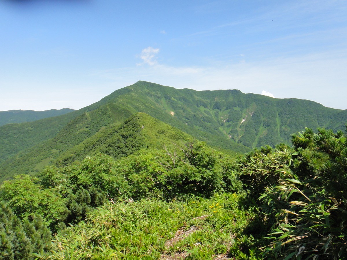
Mt. Kariba (狩場山, 1,520 m), straddling Setana and Shimamaki in Hokkaido, is one of the 300 Famous Japanese Mountains.
The highest peak of the Oshima Peninsula, it is the finest mountain of southern Hokkaido, known for its imposing form rising from the Sea of Japan and for the rich alpine flower fields that spread across its summit area. The usual Chihashiri-Shindo route starts from the Karo Plateau and is a round trip of about 7.8 km and 5 hours 30 minutes, an intermediate route on a well-trodden trail. This is brown-bear country, the mountain opening is usually late June to early July, and the forest road to the trailhead opens around the same time.
The trailhead is the Karo Plateau. There is little public transport to the trailhead, so the premise is to reach the Karo Plateau by rental car from a base such as Oshamambe Station.
The trailhead is the Chihashiri-Shindo trailhead on the Karo Plateau (beyond the Karo Falls and Chihashiri-gawa hot spring; parking available). The usual route is the Chihashiri-Shindo from the Shimamaki side (4.3 km of trail, a round trip of about 7.8 km and 5 hours 30 minutes, intermediate), while the Mozuta course (14 km) from the Setana side is the longest. The prefectural road to the Karo Plateau closes in winter, and the forest road to the trailhead usually opens in early July, so always check the opening status with the Shimamaki village Karo Plateau traffic information before you go. The forest road on the Makomanai course does not open in some years, so take care at the junction with the Chihashiri-Shindo.
Water sources are limited, so carry plenty, and bring a bear bell and bear spray against brown bears. The season is the mountain opening in late June to October, with fine alpine flowers in July. In the snow season or bad weather, beware of losing the route and of slips.
How to access the trailhead
1. [Round trip] Oshamambe Station → Karo Plateau (Mt. Kariba Chihashiri-Shindo trailhead)
The nearest rail base is Oshamambe Station (JR Hakodate Main Line / Muroran Main Line). Shimamaki village has no railway and little route-bus service to the trailhead, so the basic plan is to rent a car at a base such as Oshamambe Station and drive to the Chihashiri-Shindo trailhead on the Karo Plateau. The prefectural road to the Karo Plateau closes in winter, and the forest road to the trailhead usually opens in early July, so always check the road opening status with the Shimamaki Village Office or the Karo Plateau traffic information before setting out. The Karo Plateau has the Karo Falls and the Chihashiri-gawa hot spring, handy for an overnight stay or a stop after the descent.
– Shimamaki Village Office (Karo Plateau traffic info) 0136-75-6211 / Setana Town Office 0137-84-5111
Source: [Mt. Kariba climbing (Setana Tourism Association)]
Route and safety notes
Route: Karo Plateau Chihashiri-Shindo trailhead → Makomanai course junction → Mt. Kariba. An intermediate round trip of about 7.8 km and 5 hours 30 minutes, with flower fields across the summit area. The Mozuta course (14 km) from the Setana side is far longer.
Forest road and opening: the prefectural road to the Karo Plateau closes in winter, and the trailhead forest road usually opens in early July. The Makomanai forest road does not open in some years, so take care at the junction and check the latest road status with Shimamaki village.
Bear precautions: this is brown-bear country, so carry a bear bell and bear spray, avoid going alone, and be ready to turn back if you see droppings or tracks.
Season and gear: the season is the mountain opening in late June to October, with alpine flowers at their best in July. Water sources are limited, so carry plenty of water, bring a map and compass (GPS) and warm and rain gear, and submit a climbing plan.
In an emergency: in a mishap or accident, call 110 (police) or 119 (fire/rescue).
・Shimamaki Village Office 0136-75-6211
Photo by Northaether / Wikimedia Commons, CC BY-SA 3.0
Comments