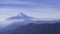
Mt. Takigoyama (たきごやま, 1,610m) in Otsuki City, Yamanashi, is the 4th-rank peak of the Shurei Fugaku Twelve Views (paired with Mt. Sasago-Gankaharasuriyama), also selected as one of the 100 Famous Yamanashi Mountains. The summit offers a stunning 360° panorama of Mt. Fuji (with Mt. Mitsutoge in the foreground), the Southern Alps, and the Kofu basin.
The trailheads are walking distance from Hatsukari Station or Sasago Station (JR Chuo Main Line). Intermediate ★★★・distance ~12 km・elevation gain 1,200 m・action time ~7 hours (day hike). The most popular route is the Sasago Stn → Michiakashi-Jizo → summit → Hinokidaira → Hatsukari Stn circuit.
Access to the trailhead
- [Outbound / Return] Otsuki Station ⇔ Hatsukari Station / Sasago Station (JR Chuo Line local)
- Three courses, circuit route, suggested plans
Course time (circuit, day hike, Intermediate, ~7 hours)
Sasago Stn (615 m) → (1:00) → Michiakashi-Jizo (820 m) → (2:30) → via Zumisawa → near summit (Otanigamaru junction) → (0:30) → Mt. Takigoyama summit (1,610 m) → (1:30) → Hinokidaira (1,094 m) → (1:30) → Hatsukari Stn (450 m)
1. [Outbound / Return] Otsuki Station ⇔ Hatsukari Station / Sasago Station (JR Chuo Line local)
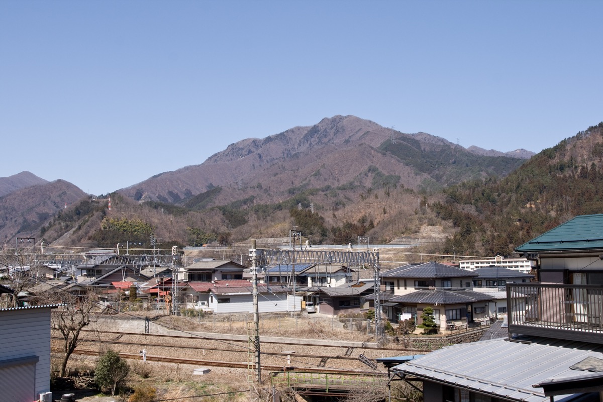
Hatsukari Station (450 m, Hinokidaira-course base) and Sasago Station (615 m, Michiakashi-Jizo / Nan-ryo base) are local-only stops on the JR Chuo Line (Limited Express bypasses these); transfer at Otsuki Station to the local. Otsuki → Hatsukari ~3 min・¥210, Otsuki → Sasago ~8 min・¥240; service approx. every 30-60 min. Private car: Sakura Shinrin Park parking (from Sasago Stn toward Michiakashi-Jizo, ~8-10 + 5 spaces, roadside free), or near Michiakashi-Jizo trailhead (roadside 5 spaces); parking is scarce around Hatsukari Station, public transport recommended.
Operating period : Year-round, JR Chuo Line local
Travel time : Otsuki Stn → Hatsukari Stn ~3 min・Sasago Stn ~8 min
Fare : Hatsukari ¥210, Sasago ¥240
Frequency : approx. every 30-60 min
Otsuki Stn → Hatsukari / Sasago Stn (JR Chuo Line local, morning hiker excerpt)
| Otsuki Stn dep | Hatsukari Stn arr | Sasago Stn arr |
|---|---|---|
| 5:55 (early morning) | 5:58 | 6:03 |
| 6:35 | 6:38 | 6:43 |
| 7:25 | 7:28 | 7:33 |
| 8:18 | 8:21 | 8:26 |
Hatsukari / Sasago Stn → Otsuki Stn (JR Chuo Line local, return, descent excerpt)
| Sasago Stn dep | Hatsukari Stn dep | Otsuki Stn arr |
|---|---|---|
| 14:55 | 15:00 | 15:03 |
| 15:55 | 16:00 | 16:03 |
| 16:55 | 17:00 | 17:03 |
| 17:55 | 18:00 | 18:03 |
Note : JR Chuo Line local timetables should always be pre-confirmed at the JR East official site. Limited Express Kaiji / Azusa bypass Hatsukari / Sasago (transfer to local at Otsuki Station required). After descent, “Tenku-no-Yu” near Otsuki Station or local bathhouses in Otsuki are recommended.
Reference : JR East Chuo Line timetable | YAMAP — Mt. Takigoyama circuit
Contact : JR Otsuki Station ☎0554-22-0029 / Otsuki City Tourism Association ☎0554-22-2942
2. Three courses, circuit route, suggested plans
About Mt. Takigoyama
At 1,610 m in Otsuki City, Yamanashi. Selected as the 4th-rank peak of Otsuki City’s Shurei Fugaku Twelve Views (paired with Mt. Sasago-Gankaharasuriyama), and one of the 100 Famous Yamanashi Mountains. Located at the southern end of the Daibosatsu Range, the summit offers a 360° panorama of Mt. Fuji with Mt. Mitsutoge in the foreground, plus the Southern Alps, the Kofu basin, and the Doshi range. A standard “station-to-summit” model with trailheads walking distance from JR Chuo Line stations.
Trail overview (3 main courses)
- Hatsukari course (via Hinokidaira, standard, Intermediate, ~4 hr ascent): Hatsukari Stn → Karasawa Bridge → Tachigawara → Anasawa-yama → Hinokidaira → summit; popular and easy-walking
- Zumisawa course (via Michiakashi-Jizo, Intermediate, ~4 hr ascent): Sasago Stn → Michiakashi-Jizo → Zumisawa → Otanigamaru junction → summit; stream-side
- Nan-ryo (Jakusho-one) course (Expert variation, ~4 hr ascent): Sasago Stn → Jakusho-one → summit; steep rocky ridge, ascent only recommended
Mountain huts / hot springs (2026 information)
– No huts on the trail: Day-hike basis, bivouac prohibited
– Sakura Shinrin Park parking: 30 min walk from Sasago Stn, roadside free 8-10 + post-gate 5 spaces
– Near Michiakashi-Jizo trailhead: Roadside free 5 spaces
– Hot springs in Otsuki: Simple bath facilities near station; consider Yamanashi-shi onsens too
Climbing season / flora: Year-round possible (winter only for advanced hikers). Late April – May: mitsuba-tsutsuji and yama-tsutsuji rhododendron; May-June: fresh greens, akayashio on the Jakusho-one ridge. October-November: autumn colors. Winter (Dec-Mar) ice / snow; light crampons recommended.
Cautions
– Nan-ryo (Jakusho-one) is Expert variation: Rocky ridge, unsuitable for descent; not for beginners
– Hinokidaira – summit also has steep climbs: Intermediate level, for fit hikers
– Limited water sources: Only Zumisawa (seasonally dry possible), carry at least 1.5 L
– Local-train transfer required at Otsuki: Limited Express bypasses Hatsukari / Sasago
– Winter ice caution: Carry light crampons / poles
Emergency contacts / inquiries
- Otsuki City Office (Tourism Association): ☎0554-22-2942 / Otsuki Police (climbing notification / mountain rescue): ☎0554-22-0110
- JR Otsuki Station: ☎0554-22-0029
- Otsuki City Fire Dept: ☎0554-22-0119
Suggested plans (circuit, day hike, recommended, standard)
- Day-hike circuit (Sasago Stn → Michiakashi-Jizo → summit → Hinokidaira → Hatsukari Stn, recommended, standard): Shinjuku 6:00 → Otsuki Stn 7:30 → Sasago Stn 7:43 → Michiakashi-Jizo 8:45 → Zumisawa → summit 12:00 → Hinokidaira 13:30 → Hatsukari Stn 15:00 → Otsuki Stn 15:03 → Shinjuku 16:30
- Nan-ryo (Jakusho-one) day-hike (strong / Expert hikers): Sasago Stn → Jakusho-one → summit → Hatsukari Stn (descent must be via Zumisawa / Hinokidaira — Jakusho-one ascent only)
Reference : YAMAP — Mt. Takigoyama circuit | Tozanguchi Navi — Sakura Shinrin Park
Photo by Ω64
Comments