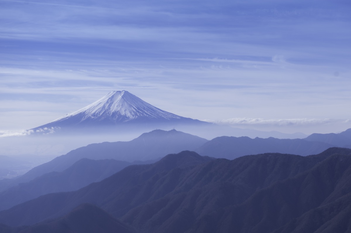
Mt. Gangaharasuriyama (がんがはらすりやま, 1,874m) in Otsuki City, Yamanashi, is the 1st-rank peak of the Shurei Fugaku Twelve Views (paired with Mt. Ubakoyama) and the highest of the twelve. Famous as the filming location for the Mt. Fuji image on the back of the old 500-yen banknote (photographed by Hisasaku Natori on November 3, 1942), it is the ultimate Mt. Fuji viewing spot.
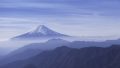
From Otoge Pass (1,560 m), the summit is reached in ~1 hr 20 min・Beginner-Intermediate ★★★, distance ~4 km・elevation gain 300 m, day-hike. The summit offers a 360° panorama of Mt. Fuji, Mt. Mitsutoge, the Southern Alps, and the Daibosatsu Range. A traverse with Mt. Ubakoyama (1,503 m, 40 min away) is recommended.
Access to the trailhead
- [Outbound / Return] Otsuki Station ⇔ Otoge (taxi / private car, no scheduled bus)
- Otoge course, Ubakoyama traverse, suggested plans
Course time (Otoge course, day hike, Beginner-Intermediate, ~3 hr round trip)
Otoge (1,560 m) → (1:20) → Mt. Gangaharasuriyama summit (1,874 m) → descent (1:00) → Otoge
(Traverse) Ubakoyama course (Intermediate, ~5 hr): Otoge → Mt. Gangaharasuriyama → (1:30) → Mt. Ubakoyama (1,503 m) → (1:30) → Kanayama Onsen
1. [Outbound / Return] Otsuki Station ⇔ Otoge (taxi / private car, no scheduled bus)
For Mt. Gangaharasuriyama trailhead Otoge (1,560 m, parking 10 spaces, toilet), there is no scheduled bus; about 1 hr 20 min by taxi from JR Otsuki Station・~¥8,000, or private car (Chuo Expressway Otsuki IC → R20 → Pref. Rd 510, ~1 hr 15 min). The R510 section between Kuwanishi parking and Otoge is closed for winter from December to late April; climbing-possible period is May – November only. The Kanayama Onsen descent point for the Ubakoyama traverse requires advance taxi arrangement.
Operating period : Private car / taxi year-round (R510 Kuwanishi-Otoge section closed Dec-late Apr)
Travel time : Otsuki Stn → Otoge (taxi) ~1 hr 20 min
Fare : Taxi ~¥8,000 (one-way)
Frequency : No public scheduled bus, reservation taxi required
Otsuki Stn ⇔ Otoge (taxi / private car, no scheduled bus, reference)
| Otsuki Stn dep | Otoge arr |
|---|---|
| Taxi (reservation required) | ~1 hr 20 min・¥8,000 |
| Private car (via Otsuki IC) | ~1 hr 15 min |
Note : There is no public scheduled bus to Otoge; taxi must be pre-reserved at Otsuki Station front (book the return leg too). Private car: R510 past Kuwanishi parking closed Dec – late Apr; even during season, road may close in bad weather — verify with Otsuki City Office. After descent, “Tenku-no-Yu” near Otsuki Station or Kanayama Onsen (when doing Ubakoyama traverse) is recommended.
Reference : Tozanguchi Navi — Otoge parking | Otsuki City official — Mt. Gangaharasuriyama course PDF
Contact : Otsuki Tourism Association ☎0554-22-2942 / Otsuki Taxi ☎0554-22-2120
2. Otoge course, Ubakoyama traverse, suggested plans
About Mt. Gangaharasuriyama
The Shurei Fugaku Twelve Views are mountains chosen by Otsuki City for their outstanding views of Mt. Fuji, with 20 summits spread across numbers 1 to 12. Mt. Gangaharasuriyama, paired with Mt. Ubakoyama to the south, is chosen as the 1st-rank peak and at 1,874m is the highest of the Twelve Views. Its name “Gangaharasuri” comes from the mountain appearing so high that geese and ducks brush their bellies against it as they fly over. With only a small elevation gain from the trailhead, this Mt. Fuji viewpoint can be climbed with relative ease.
Trail overview (2 main courses)
- Otoge course (standard, Beginner-Intermediate, ~3 hr round trip): Otoge → summit round trip; shortest, most popular, Mt. Fuji panorama
- Ubakoyama traverse (Intermediate, ~5 hr): Otoge → Mt. Gangaharasuriyama → Mt. Ubakoyama → Kanayama Onsen; completes the 1st-rank peak of Shurei Fugaku
- (Reference) Kanayama-kosen course (Intermediate, 4 hr ascent): Kanayama-kosen → Mt. Ubakoyama → Mt. Gangaharasuriyama; reverse route
Mountain huts / hot springs (2026 information)
– No huts on the trail: Day-hike basis
– Otoge parking: 10 spaces, free, toilet (in season)
– Kanayama Onsen “Kanayama-kosen Yamaguchi-kan”: Traverse descent point, day-bath available
– “Tenku-no-Yu” near Otsuki Station: Drop-in bath
Climbing season / flora: May to November (R510 closed in winter). May: fresh greens, mitsuba-tsutsuji; June-July: rhododendron, alpine plants. October-November: autumn colors. Winter (Dec-Mar) is effectively unclimbable due to road closure.
Cautions
– R510 Kuwanishi-Otoge section closed Dec – late Apr: Climbing-possible period May-Nov
– No scheduled bus: Taxi or private car; book return taxi in advance
– Otoge parking 10 spaces: Frequently full on autumn-color weekends; early morning arrival recommended
– No water source: Carry at least 1 L
– Ubakoyama traverse for fit hikers: 5 hr, taxi arrangement to Kanayama Onsen descent point essential
Emergency contacts / inquiries
- Otsuki City Office (Tourism Association): ☎0554-22-2942 / Otsuki Police (climbing notification / mountain rescue): ☎0554-22-0110
- Otsuki Taxi: ☎0554-22-2120 / JR Otsuki Station: ☎0554-22-0029
- Kanayama-kosen Yamaguchi-kan (traverse descent): ☎0554-22-1730
Suggested plans (Otoge course, day hike, recommended, standard)
- Day-hike Otoge round trip (recommended, Beginner-Intermediate, standard): Shinjuku 6:00 → Otsuki Stn 7:30 → taxi → Otoge 9:00 → summit 10:20 (Mt. Fuji panorama) → descent → Otoge 11:30 → taxi → Otsuki Stn 13:00 → return
- Ubakoyama traverse (fit / Intermediate hikers, complete 1st-rank Shurei Fugaku): Otsuki Stn → taxi → Otoge → Mt. Gangaharasuriyama → Mt. Ubakoyama → descend to Kanayama Onsen → taxi → Otsuki Stn
Reference : Otsuki City official — Mt. Gangaharasuriyama course PDF | Otsuki Tourism — Mt. Gangaharasuriyama
Photo by kaoru hayashi
Comments