
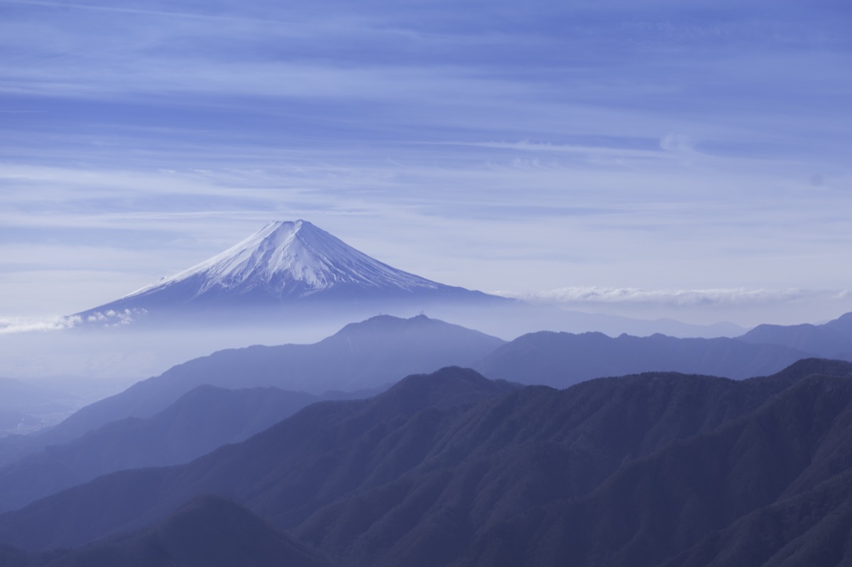
Mt. Ubakoyama (うばこやま, 1,503m) in Otsuki City, Yamanashi, is the 1st-rank peak of the Shurei Fugaku Twelve Views (paired with Mt. Gangaharasuriyama). A renowned Mt. Fuji viewpoint alongside Mt. Gangaharasuriyama, its distinctive rocky summit offers stunning views of Mt. Fuji, Mt. Mitsutoge, and the Southern Alps.
Standard routes are the standalone Kanayama-kosen ascent (~4 hr up) or the traverse from Mt. Gangaharasuriyama (Otoge → Mt. Gangaharasuriyama → Mt. Ubakoyama → Kanayama-kosen, ~5 hr). Intermediate ★★★・distance ~8 km・elevation gain 900 m. The summit splits east/west; the east peak offers especially good Mt. Fuji views.
Access to the trailhead
- [Outbound / Return] Otsuki Station ⇔ Onoudo / Kanayama-kosen (Fujikyu Yamanashi Bus / private car)
- Kanayama-kosen route, Mt. Gangaharasuriyama traverse, suggested plans
Course time (Kanayama-kosen out-and-back, day hike, Intermediate, ~8 hr round trip)
Kanayama-kosen (640 m) → (3:00) → Mt. Ubakoyama East Peak (1,503 m, Mt. Fuji view) → (0:20) → Mt. Ubakoyama West Peak → descent (3:00) → Kanayama-kosen
(Traverse) Otoge → Mt. Gangaharasuriyama → Mt. Ubakoyama course (Intermediate, ~5 hr): Otoge → Mt. Gangaharasuriyama (1,874 m) → (1:30) → Mt. Ubakoyama (1,503 m) → (1:30) → Kanayama-kosen
1. [Outbound / Return] Otsuki Station ⇔ Onoudo / Kanayama-kosen (Fujikyu Yamanashi Bus / private car)
For the Mt. Ubakoyama trailhead Kanayama-kosen site (640 m, closed March 2019, trailhead use possible), from JR Otsuki Station take Fujikyu Yamanashi Bus “Nishi-Okuyama Line” to Onoudo bus stop (~15 min・~¥300), then 1 hr walk to Kanayama-kosen. Private car: Chuo Expressway Otsuki IC → R20 → Pref. Rd 512 (turn left before Otsuki City Office, right at Y-junction 3.3 km ahead), ~20 min to Kanayama-kosen, parking few spaces, free. Fujikyu Yamanashi Bus has limited services — pre-confirm the timetable.
Operating period : Fujikyu Yamanashi Bus Nishi-Okuyama Line year-round (limited services); private car year-round (Otoge road closed Dec – late Apr for winter)
Travel time : Otsuki Stn → Onoudo ~15 min (bus) + 1 hr walk (to Kanayama-kosen)
Fare : Bus ~¥300, private car free
Frequency : A few services per day (verify timetable)
Otsuki Stn → Onoudo (Fujikyu Yamanashi Bus Nishi-Okuyama Line, morning hiker excerpt)
| Otsuki Stn dep | Onoudo arr |
|---|---|
| ~7:30 (morning) | ~7:45 |
| ~9:30 (mid-morning) | ~9:45 |
Onoudo → Otsuki Stn (Fujikyu Yamanashi Bus Nishi-Okuyama Line, return)
| Onoudo dep | Otsuki Stn arr |
|---|---|
| ~14:00 | ~14:15 |
| ~16:30 (last) | ~16:45 |
Note : Fujikyu Yamanashi Bus Nishi-Okuyama Line timetables should always be pre-confirmed at the Fujikyu Yamanashi Bus official or Otsuki City Office. Services are limited; if you miss the last bus, you’ll need a 1 hr walk + taxi back to Otsuki Station. Kanayama-kosen Yamaguchi-kan closed March 2019, no lodging or bath. After descent, “Tenku-no-Yu” near Otsuki Station or local bath facilities are recommended.
Reference : Tozanguchi Navi — Kanayama-kosen | Otsuki Tourism — Mt. Ubakoyama
Contact : Fujikyu Yamanashi Bus ☎0555-72-6877 / Otsuki Tourism Association ☎0554-22-2942
2. Kanayama-kosen route, Mt. Gangaharasuriyama traverse, suggested plans
About Mt. Ubakoyama
At 1,503 m in Otsuki City, Yamanashi. Selected as the 1st-rank peak of Otsuki City’s Shurei Fugaku Twelve Views (paired with Mt. Gangaharasuriyama), a renowned Mt. Fuji viewpoint alongside its partner peak. The summit splits into east and west peaks, with the east peak offering especially stunning Mt. Fuji views. To completely conquer the 1st-rank peaks of Shurei Fugaku, the traverse with Mt. Gangaharasuriyama is the standard.
Trail overview (2 main courses)
- Kanayama-kosen out-and-back (Intermediate, ~8 hr round trip): Kanayama-kosen site → Mt. Ubakoyama round trip; standalone ascent
- Otoge → Mt. Gangaharasuriyama → Mt. Ubakoyama traverse (Intermediate, ~5 hr): Otoge → Mt. Gangaharasuriyama → Mt. Ubakoyama → Kanayama-kosen; complete 1st-rank Shurei Fugaku conquest (recommended)
Mountain huts / hot springs (2026 information)
– Kanayama-kosen Yamaguchi-kan closed March 2019: No lodging or bath; trailhead / parking still usable
– “Tenku-no-Yu” near Otsuki Station: Post-descent drop-in bath
– Otoge parking: 10 spaces, free, toilet (traverse start, Otoge road closed in winter)
Climbing season / flora: May to November (Otoge road closed in winter). May: fresh greens, mitsuba-tsutsuji; June: rhododendron. October-November: autumn colors. Winter (Dec-Mar) — Otoge route closed, Kanayama-kosen route possible but with snow / ice; Intermediate-plus only.
Cautions
– Kanayama-kosen Yamaguchi-kan closed: No lodging since 2019, factor into planning
– Limited Fujikyu Yamanashi Bus services: Verify last service; missing it means walk + taxi
– Otoge road closed early Dec – late Apr: Traverse course not feasible off-season
– Limited water sources: Only Kanayama-kosen site, carry at least 1.5 L
– Rocky summit area: Careful walking required
Emergency contacts / inquiries
- Otsuki City Office (Tourism Association): ☎0554-22-2942 / Otsuki Police (climbing notification / mountain rescue): ☎0554-22-0110
- Fujikyu Yamanashi Bus: ☎0555-72-6877 / JR Otsuki Station: ☎0554-22-0029
- Otsuki Taxi: ☎0554-22-2120
Suggested plans (Otoge → Mt. Gangaharasuriyama → Mt. Ubakoyama traverse, recommended, standard)
- Day-hike traverse (complete 1st-rank Shurei Fugaku, recommended, Intermediate): Shinjuku 6:00 → Otsuki Stn 7:30 → taxi → Otoge 9:00 → Mt. Gangaharasuriyama 10:20 → Mt. Ubakoyama 12:30 → Kanayama-kosen 14:30 → bus or walk → Otsuki Stn 16:00 → return
- Kanayama-kosen out-and-back (Intermediate, standalone): Otsuki Stn → bus → Onoudo → walk → Kanayama-kosen → Mt. Ubakoyama round trip → Otsuki Stn
Reference : Tozanguchi Navi — Kanayama-kosen | Otsuki Tourism — Mt. Ubakoyama
Photo by kaoru hayashi
Comments