
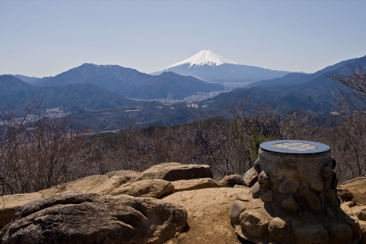
Mt. Takagawayama (たかがわやま, 976m) on the border of Otsuki City and Tsuru City, Yamanashi, is the 11th-rank peak of the Shurei Fugaku Twelve Views. Beginner-friendly at under 1,000 m, the summit nonetheless offers a 360° panorama of Mt. Fuji, Mt. Mitsutoge, Mt. Mishotai, and the Southern Alps.
The Hatsukari Stn → summit → Tanokura Stn / Kasei Stn / Otsuki Stn traverse (descent station selectable) is popular. Beginner ★★・distance ~6 km・elevation gain 530 m・action time ~3-4 hours (day hike). Combining JR Chuo Line and Fujikyu Railway, this is a standard “station-to-summit” model, accessible as a day-hike from Shinjuku.
Access to the trailhead
- [Outbound / Return] Otsuki Stn ⇔ Hatsukari Stn / Tanokura Stn / Kasei Stn (JR Chuo Line / Fujikyu Railway)
- Multiple courses, traverse routes, suggested plans
Course time (Hatsukari Stn → Tanokura Stn traverse, day hike, Beginner, ~4 hours)
Hatsukari Stn (450 m) → (0:10) → trailhead → (2:00) → Mt. Takagawayama summit (976 m) → (1:50) → Tanokura Stn (Matsuba/Nakatani course, Fujikyu Railway)
1. [Outbound / Return] Otsuki Stn ⇔ Hatsukari Stn / Tanokura Stn / Kasei Stn (JR Chuo Line / Fujikyu Railway)
Hatsukari Station (450 m, trailhead, JR Chuo Line local-only), Tanokura Station (Matsuba/Nakatani course descent, Fujikyu Railway), and Kasei Station (Furujuku course descent, Fujikyu Railway) are on different lines. At Otsuki Station, transfer to JR Chuo Line local (toward Hatsukari) or Fujikyu Railway (toward Tanokura / Kasei). Otsuki → Hatsukari ~3 min・¥210, Otsuki → Tanokura ~18 min・¥440, Otsuki → Kasei ~15 min・¥420. Service approx. every 30-60 min. Private car: roadside parking near Hatsukari Station (few spaces), or Michi-no-Eki Tsuru (Tsuru City) is also nearby.
Operating period : Year-round, JR Chuo Line local / Fujikyu Railway
Travel time : Otsuki Stn → Hatsukari ~3 min・Tanokura ~18 min・Kasei ~15 min
Fare : Hatsukari ¥210, Tanokura ¥440, Kasei ¥420
Frequency : approx. every 30-60 min
Otsuki Stn → Hatsukari Stn (JR Chuo Line local, morning hiker excerpt)
| Otsuki Stn dep | Hatsukari Stn arr |
|---|---|
| 5:55 (early) | 5:58 |
| 6:35 | 6:38 |
| 7:25 | 7:28 |
| 8:18 | 8:21 |
Tanokura Stn / Kasei Stn / Hatsukari Stn → Otsuki Stn (return, Fujikyu Railway / JR Chuo Line excerpt)
| Descent Stn dep | Line | Otsuki Stn arr |
|---|---|---|
| Tanokura 14:38 | Fujikyu Railway | 14:56 |
| Kasei 14:48 | Fujikyu Railway | 15:03 |
| Hatsukari 15:00 | JR Chuo Line | 15:03 |
| Tanokura 16:25 | Fujikyu Railway | 16:43 |
Note : JR Chuo Line local and Fujikyu Railway timetables should always be pre-confirmed at the JR East / Fujikyu Railway official sites. Limited Express Kaiji / Azusa bypass Hatsukari Station (transfer to local at Otsuki required). After descent, “Tenku-no-Yu” near Otsuki Station or Tsuru City onsens are recommended.
Reference : JR East Chuo Line timetable | Fujikyu Railway official
Contact : JR Otsuki Station ☎0554-22-0029 / Otsuki Tourism Association ☎0554-22-2942
2. Multiple courses, traverse routes, suggested plans
About Mt. Takagawayama
At 976 m on the Otsuki / Tsuru City border, Yamanashi. Selected as the 11th-rank peak of Otsuki City’s Shurei Fugaku Twelve Views, and one of the Yamanashi Hiking 100 Courses. Despite being under 1,000 m, the summit offers a 360° panorama overlooking majestic Mt. Fuji, Mt. Mitsutoge, Mt. Mishotai, and the Southern Alps, with a view-direction plate. Ideal for beginners and family climbs, a gateway peak into the Shurei Fugaku Twelve Views.
Trail overview (4 main courses, descent station selectable)
- Hatsukari → Tanokura traverse (Matsuba/Nakatani course, Beginner, ~4 hr): JR Hatsukari Stn → summit → Fujikyu Tanokura Stn; popular and shortest
- Hatsukari → Kasei traverse (Furujuku course, Beginner, ~4 hr): JR Hatsukari Stn → summit → Fujikyu Kasei Stn
- Hatsukari → Otsuki traverse (Musubiyama traverse course, Intermediate, ~5 hr): JR Hatsukari Stn → summit → Mt. Mineyama → Mt. Okiyama → Mt. Musubiyama → JR Otsuki Stn; full traverse
- Hatsukari out-and-back (Beginner, ~4 hr): JR Hatsukari Stn → summit round trip; simple
Mountain huts / hot springs (2026 information)
– No huts on the trail: Day-hike basis
– Roadside parking near Hatsukari Station: Few spaces
– “Tenku-no-Yu” near Otsuki Station: Drop-in bath
– Michi-no-Eki Tsuru (Tsuru City): Post-descent stop, toilet / meals
Climbing season / flora: Year-round possible (winter with light crampons). April-May: mitsuba-tsutsuji, fresh greens; October-November: autumn colors. Winter (Dec-Feb) has snow / ice but climbing possible with light crampons.
Cautions
– Local / Fujikyu Railway transfer required at Otsuki: Limited Express bypasses Hatsukari
– No water source: Carry at least 1 L; heat caution in summer
– Pre-decide traverse descent station: Multiple route junctions
– Winter ice caution: Light crampons recommended
Emergency contacts / inquiries
- Otsuki City Office (Tourism Association): ☎0554-22-2942 / Tsuru City Office: ☎0554-43-1111
- Otsuki Police (climbing notification / mountain rescue): ☎0554-22-0110
- JR Otsuki Station: ☎0554-22-0029 / Fujikyu Railway: ☎0555-22-7133
Suggested plans (Hatsukari → Tanokura traverse, day hike, recommended, standard)
- Day-hike traverse (Hatsukari → Tanokura, recommended, Beginner): Shinjuku 7:00 → Otsuki Stn 8:30 → Hatsukari Stn 8:38 → trailhead 8:50 → summit 10:50 (Mt. Fuji panorama) → Tanokura Stn 12:40 → Otsuki Stn 13:00 → return
- Musubiyama traverse (Intermediate, full): Hatsukari Stn → summit → Mt. Mineyama → Mt. Musubiyama → Otsuki Stn (~5 hr)
Reference : Yamanashi Hiking — Mt. Takagawayama | Michi-no-Eki Tsuru — Mt. Takagawayama guide
Photo by Ω64
Comments