
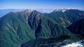
Mt. Sasayama (笹山, also Kurokouchidake; North Peak 2,733 m / South Peak 2,717.6 m), straddling Yamanashi and Shizuoka on the Shirane South Ridge of the Southern Alps, is one of the 300 Famous Japanese Mountains.
Also called Kurokouchidake, it is a twin-peaked mountain with the triangulation point on the South Peak; its summit is covered in creeping pine and looks out over the Shirane South Ridge and the southern Southern Alps including Mt. Shiomi, a quiet peak also chosen as one of the 100 Famous Mountains of Yamanashi. The usual route is the Sasayama Direct Ridge from Narada, which climbs about 2,000 m of gain in about 6.5 km one way (a round trip of about 13 km with about 1,944 m of gain), a steep, advanced route of continuous climbing. The standard is two days with a tent camp midway, though fit hikers can do it as a day trip, which is a real test of stamina.
The gateway is Narada. From a station on the Minobu Line you can reach Narada by Hayakawa Town’s community bus, so it can be approached by public transport.
The climb starts at Narada; the Sasayama Direct Ridge goes trailhead → water-source entrance → Sasayama South Peak → North Peak, an advanced course of about 13 km round trip with about 1,944 m of gain and continuous steep climbing. The standard is to camp at a tent site around 2,335 m and attack the summit before dawn the next morning; fit hikers can do it as a day trip from Narada, but the elevation gain is large. There is a water source midway up the ridge, and a short way on from the creeping-pine summit the view opens up; Sasayama is also the start and end point of the Shirane South Ridge traverse toward Mt. Notori and Daimonzawa.
As the climbing is continuous and steep, carry a map and compass (GPS) and plenty of water and food. The season is late June to October; outside it, beware of snow and ice.
How to access the trailhead
1. [Round trip] Shimobe-Onsen / Minobu Station → Narada (Sasayama Direct Ridge trailhead)
To the gateway Narada, take Hayakawa Town’s community bus to Narada Onsen from Shimobe-Onsen or Minobu Station on the JR Minobu Line (about 1 hour 30 minutes from Minobu Station, fare 1,000 yen, plus 200 yen for a large pack, running almost year-round). In summer you can also reach Narada from Kofu Station on the Yamanashi Kotsu Southern Alps climbing bus (transfer at Hirogawara on the Kofu–Hirogawara run, then Hirogawara–Narada), a seasonal service usually late June to early November. It is safest to stay the night before at Narada Onsen and start early; in either case check the bus times and operating period with the official information of Hayakawa Town and Yamanashi Kotsu in advance.
– Hayakawa Town Community Bus (Hayakawa Town Office) 0556-45-2511 / Yamanashi Kotsu 055-223-0821
Source: [Hayakawa Town official site]
Route and safety notes
Route: Narada → Sasayama Direct Ridge trailhead → water-source entrance → Sasayama South Peak → North Peak → return the way you came. An advanced course of about 13 km round trip with about 1,944 m of gain and continuous steep climbing; the standard is two days.
Access and bus: reach Narada by Hayakawa Town’s community bus from a Minobu Line station (year-round), or in summer by the Yamanashi Kotsu Southern Alps climbing bus from Kofu Station (transfer at Hirogawara). Check the bus times and operating period in advance.
Steep climb and water: as there is about 2,000 m of continuous steep gain, make an early start. There is a water source midway up the ridge, but carry plenty of water and food.
Season and gear: the season is late June to October; outside it, beware of snow and ice. Carry a map and compass (GPS), submit a climbing plan, and consider tent-camping gear.
In an emergency: in a mishap or accident, call 110 (police) or 119 (fire/rescue).
・Hayakawa Town Office 0556-45-2511 / Nanbu Police Station 0556-64-2611
Photo by Alpsdake / Wikimedia Commons, Public domain
Comments