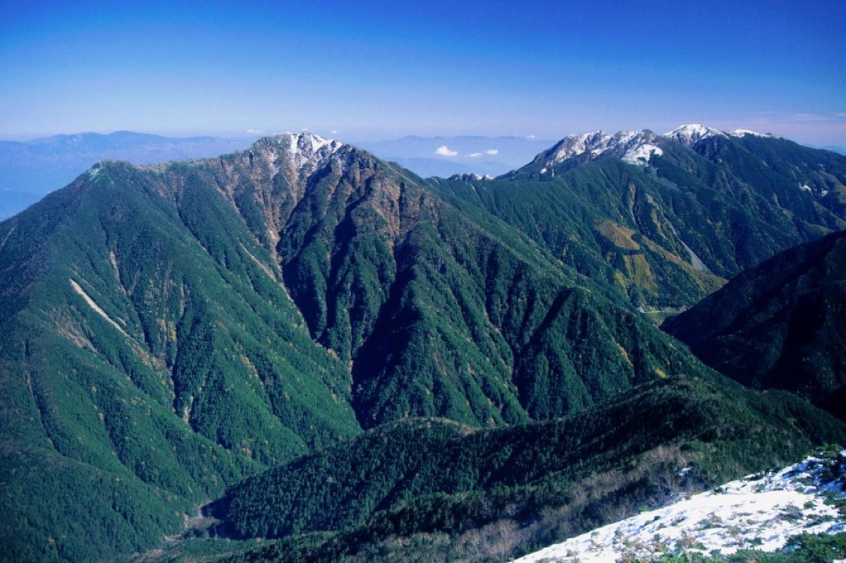
Mount Asayo (Asayomine, 2,799 m) straddles Minami-Alps City and Hokuto City in Yamanashi, and is one of Japan’s 300 Famous Mountains.
It is the highest point of the Hayakawa Ridge linking Mount Kaikoma and the Hōō Three Peaks, and its appeal lies in one of the Southern Alps’ finest views from the summit, taking in Mount Kita, Mount Senjō, Mount Kaikoma, the Hōō Three Peaks, the Yatsugatake range and Mount Fuji. It is an out-and-back over the rocky ridge from Kitazawa Pass via Mount Kurisawa, an advanced route that includes rock scrambling between Kurisawa and Asayo.
To reach the Kitazawa Pass trailhead, you take a seasonal bus from Chino Station and then change to the South Alps Forest Road bus.
The start is Kitazawa Pass (2,030 m), the terminus of the South Alps Forest Road bus. The main route is Kitazawa Pass → Chōei Hut → Mount Kurisawa → Mount Asayo (2,799 m) and back, with a standard time of about 3 hours 10 minutes up and about 3 hours 5 minutes down (a loop via Senzui Pass), an advanced route over the rocky ridge beyond Kurisawa. Fit hikers can do it as a day trip using the first bus, but staying at Kitazawa Pass (Komorebi Hut or Chōei Hut) the night before or after gives you more time.
The best season is summer to early autumn (July–September); the Kurisawa-to-Asayo ridge offers unbroken, wide-open views. Always check the bus operating period and the latest times before you go.
*Last checked: June 8, 2026
How to access the trailheads
1. [There & Back] Chino Station ⇄ Kitazawa Pass (Geo Liner + South Alps Forest Road bus)
Chino Station on the JR Chūō Main Line, where the “Azusa” limited express stops, or Ina-shi and Ina-kita Stations on the JR Iida Line, are your bases. Private cars are restricted near Kitazawa Pass, so you must change to the forest-road bus.
① Chino Station → Todai Park (South Alps Geo Liner)
The JR Bus Kanto South Alps Geo Liner runs directly from Chino Station via Takatō to Todai Park (Senryūsō). In 2026 it runs on Fridays, Saturdays, Sundays and holidays from July 17 to October 12 (and daily from July 31 to August 16 and from September 18 to September 27), and the fare from Chino is ¥1,800.
— JR Bus Kanto, Ina office 0265-73-7171.
② Todai Park → Kitazawa Pass (South Alps Forest Road bus)
From Todai Park (Todaiguchi) it is about 50 minutes by the South Alps Forest Road bus to Kitazawa Pass, ¥1,240 one way (a luggage charge of ¥90–220 applies for packs of 18 L or more). It runs from June 1 to November 3; the first uphill bus is roughly 6:30 (5:45 in midsummer) and the last uphill bus is 14:15, with extra services added when busy.
— South Alps Forest Road Bus Office 0265-98-2821.
③ Outside the Geo Liner period / weekdays: take the JR Bus Kanto “Takatō line” from Ina-shi or Ina-kita Station to Takatō Station (about 25 minutes), then the Hase loop bus to Todai Park. As the Hase loop bus runs only on weekdays, on weekends and holidays outside the Geo Liner period it is most reliable to take a taxi from Ina-shi or Ina-kita Station to Todai Park.
— Ina Tsubame Taxi 0265-76-5111 / Shirakawa Taxi, Takatō office 0265-94-2046.
By car: there is a paid car park at Todai Park, about 40 minutes from the Ina IC or Ogurogawa Smart IC on the Chūō Expressway. Change to the forest-road bus for Kitazawa Pass.
References: [Ina City Official: South Alps Forest Road Bus] / [Minami-Alps NET: Mount Asayo]
Trail Guide and Safety Notes
Route: from Kitazawa Pass (2,030 m), climb via Chōei Hut directly to Mount Kurisawa, then follow the ridge out and back to Mount Asayo (2,799 m). The standard time is about 3 hours 10 minutes up and about 3 hours 5 minutes down (a loop via Senzui Pass), an advanced route that includes the rocky ridge beyond Kurisawa. There is also a long traverse of the Hayakawa Ridge from Hirokawara Pass.
Rocky ridge and weather: between Kurisawa and Asayo the route crosses a ridge of piled-up boulders, following paint marks and cairns. It is easy to lose the line in poor visibility, so take care. At this altitude be ready for sudden weather changes, lightning and cold, and start and finish early.
Views and huts: from the summit there is a panorama of Mount Kita, Mount Senjō, Mount Kaikoma, the Hōō Three Peaks, the Yatsugatake range and Mount Fuji. Komorebi Hut and Chōei Hut (with a campsite) at Kitazawa Pass make good bases for staying the night before or after.
Equipment and emergencies: carry rain gear, warm clothing, a headlamp, a map/GPS, plenty of food and water. In an accident or emergency call 110 (police) or 119 (fire/ambulance).
・Ina Police Station 0265-72-0110
Photo by Alpsdake / Wikimedia Commons, Public domain
Comments