Contents

Mt. Aino

3,190m · Yamanashi

Timetable checked 2026/05/30
Mt. Aino3,190 mYamanashi
🚃 Reachable by public transport · consider an overnight · Intermediate · for reasonably fit hikers
Access ease Moderate Direct hiking bus
Gateway station Kōfu Station  →  Trailhead Hirogawara
1 public-transport routes ・ Station→trailhead approx. 115 min ・ One way ¥2,400
Intermediate
Stamina6/10
TechnicalC rocky sections / chains Official
Trail time 15h 58mestimated
More figures and data sources
Distance 17.55 kmmeasuredTotal ascent ↑2,302 mmeasuredHighest point 3,192 m
📍 Distance, ascent and trail time are for the route shown on the map.
🌸 Best season: Jul, Oct bk
“bk” = data from books (being replaced with our own measurements). Distance, ascent and trail time are measured/estimated from the map route.

Mt. Aino (間ノ岳) is a 3,189.5m peak in the northern Southern Alps.
Tied for the third-highest peak in Japan (the same elevation as Mt. Okuhotaka), it is counted among the 100 Famous Japanese Mountains, the 100 Famous Mountains of Koshinetsu, and the 100 Famous Mountains of Yamanashi.

The standard climb is via Mt. Kita, with Hirogawara as the trailhead.
By train, the Yamanashi Kotsu Southern Alps Climbing Bus departs from Kofu Station.
Because Mt. Aino is reached by crossing Mt. Kita from Hirogawara and returning the same way, the trip normally involves an overnight stay at a hut such as Kitadake Sanso. Even taking the first bus, completing the round trip in a single day before the last bus is unrealistic even for strong hikers, so plan on an overnight stay in the mountains.

*Timetable last checked: May 30, 2026

Hiking Course Details — Mt. Aino

Click to show current location.
Click for full-screen view.

Map & Recommended Route — Mt. Aino

Mt. Aino — Reference Hiking Times

Standard pace; times rounded to 5 min
Segment Distance Ascent/Descent Forward Reverse
Start → Hirogawara Hut 0.3 km +24 m / −9 m 0:05 0:05
Hirogawara Hut → Latriny 4.3 km +1484 m / −20 m 4:15 5:15
Latriny → Kitadake Kata-no-Koya 0.2 km +18 m / −0 m 0:05 0:05
Kitadake Kata-no-Koya → Mount Kita 0.6 km +185 m / −9 m 0:40 0:45
Mount Kita → Mount Nakashirane 2.2 km +187 m / −322 m 1:55 1:50
Mount Nakashirane → Ainodake 1.6 km +176 m / −43 m 1:00 0:55
Ainodake → Kitadake Sanso 2.5 km +44 m / −347 m 1:35 1:40
Kitadake Sanso → Hachihonba-no-Col 1.3 km +123 m / −118 m 1:00 0:50
Hachihonba-no-Col → Latriny 1.3 km +5 m / −656 m 2:20 1:45
Latriny → Shiraneike Hut 0.8 km +29 m / −38 m 0:20 0:20
Shiraneike Hut → Goal 2.6 km +27 m / −738 m 2:40 2:10
Total 17.6 km +2302 m / −2300 m 15:55 15:45

1. [Outbound] Kofu Station → Hirogawara

From the bus stop at the south exit of JR Kofu Station, take the Yamanashi Kotsu Southern Alps Climbing Bus “Hirogawara Line” and get off at “Hirogawara”.
Travel time: about 1 hour 55 minutes
Fare: ¥2,400 + ¥300 (user cooperation fee)

Operating period: typically late June to early November

Bus TimetableKofu Station to Hirogawara Bus Timetable

Weekday service
Kofu Station Hirogawara
9:05 10:58
10:05 11:58
12:05 13:58
Holiday / summer service
Kofu Station Hirogawara
4:35 6:28
6:55 8:48
9:05 10:58
10:05 11:58
12:05 13:58
14:05 15:58

Reference: [Yamanashi Kotsu]

2. [Return] Hirogawara → Kofu Station

From Hirogawara, take the Yamanashi Kotsu Southern Alps Climbing Bus “Hirogawara Line” and get off at Kofu Station.
Travel time: about 1 hour 55 minutes
Fare: ¥2,400 + ¥300 (user cooperation fee)

Operating period: typically late June to early November

Bus TimetableHirogawara to Kofu Station Bus Timetable

Weekday service
Hirogawara Kofu Station
10:00 11:55
12:00 13:55
14:00 15:55
16:35 18:30
Holiday / summer service
Hirogawara Kofu Station
10:00 11:55
11:00 12:55
12:00 13:55
14:00 15:55
16:35 18:30

Reference: [Yamanashi Kotsu]

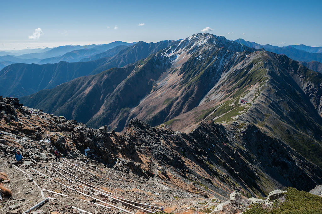
Photo by Kirill Skorobogatov
Your next mountain

Mt. Fuji - Yoshida Trailhead 100 Famous Mountains
IntermediateModerate🚃Tokyo 2h 18OvernightTrail time 11h 0215.46 km

The most popular route up Japan's highest mountain, ascending via the well-equipped Yoshida trailhead.

Mt. Hōō 100 Famous Mountains
IntermediateEasy🚃Tokyo 2h 30OvernightTrail time 10h 00

A three-peaked range of white sand ridges, towering boulders, cascades, and the iconic Obelisk, with commanding views of Kitadake and Fuji.

Mt. Shichimen 200 Famous Mountains
IntermediateEasy🚃Tokyo 4h 51OvernightTrail time 8h 00

A Nichiren sacred mountain celebrated for the Fuji sunrise seen from Keishin-in, reached by a reverent approach of 50 stone-marked stages.

Mt. Kaikomagatake 100 Famous Mountains
IntermediateEasy🚃Tokyo 3h 46Day tripTrail time 6h 427.22 km

The northern sentinel of the southern Alps, nicknamed the Southern Alps Prince for its striking white granite ridgeline.

Climbed it? Stamp your logbook