Mount Ningyō (Ningyōzan, 1,726 m) sits on the border of Nanto City in Toyama and Shirakawa Village in Gifu, and is one of Japan’s 300 Famous Mountains.
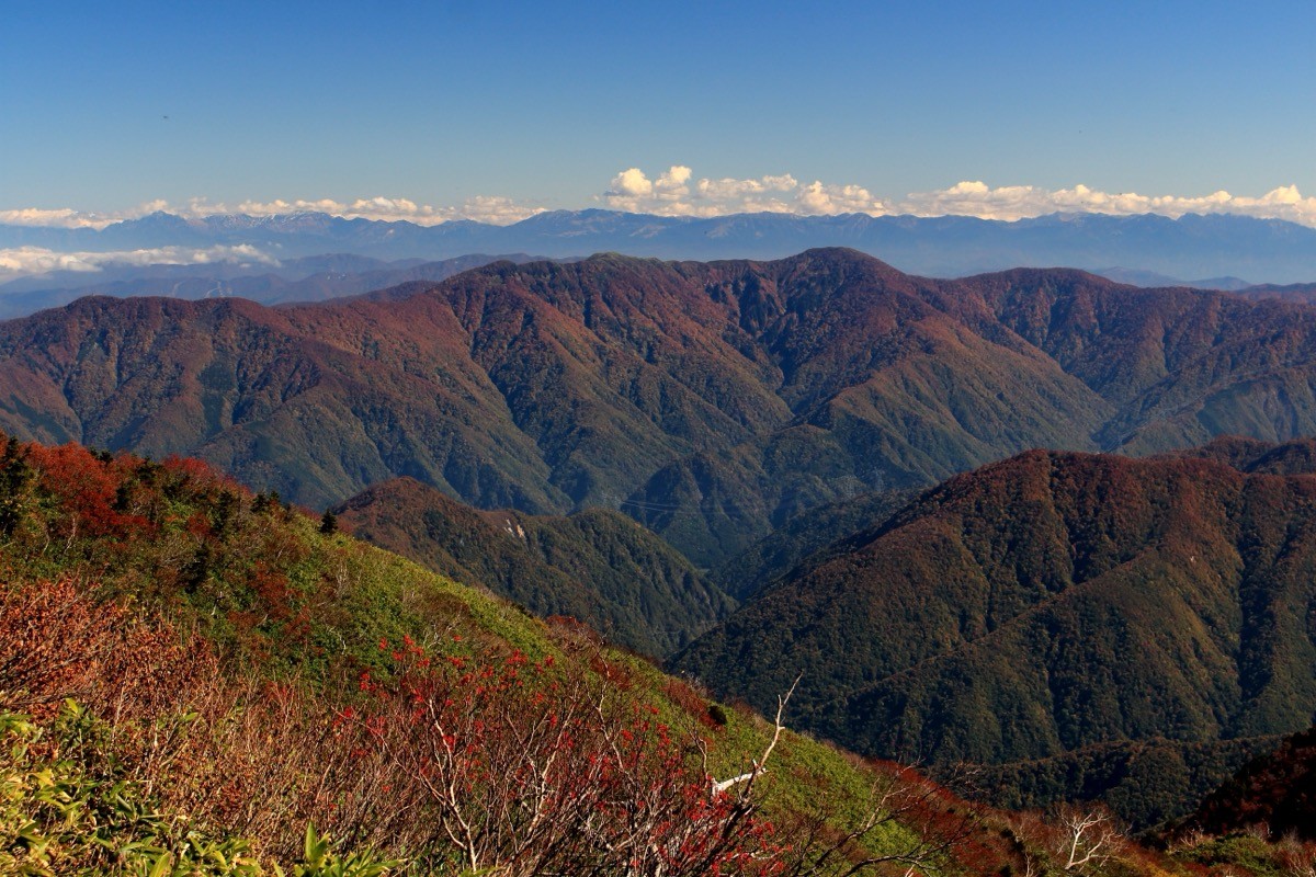
Its name comes from a snow pattern of two sisters holding hands that appears on the slopes in spring, and its appeal lies in the beech forest overlooking Gokayama and Shirakawa-gō and the views of Mount Haku and the Northern Alps. From the Nakanedaira trailhead via the Nakane hut to the summit is about 4 hours one way, an intermediate-to-strenuous route.
There is no direct bus to the trailhead, so you reach it by taxi from Jōhana Station on the JR Jōhana Line to Nakanedaira.
The trailhead is Nakanedaira (about 720 m), with the unstaffed Nakane hut (capacity 15). The main route is Nakanedaira → the Miyayashiki site → Mount Ningyō (1,726 m) and back, about 4 hours one way to the summit, an intermediate-to-strenuous route. From the summit and ridge there are views of Mount Haku, the Northern Alps and the mountains of Gokayama.
The best season is early summer to autumn (June–October); the snow pattern is seen from around Kaminashi at the foot in early spring. As the Takanari forest road to Nakanedaira is in poor condition, always check the latest road conditions and arrange a taxi before you go.
*Last checked: June 7, 2026
How to access the trailheads
1. [There & Back] Jōhana Station ⇄ Nakanedaira trailhead (Jōhana Line + taxi)
Jōhana Station on the JR Jōhana Line is your base. There is no direct bus to Mount Ningyō, so take a taxi from the station.
① Jōhana Station → Nakanedaira trailhead (taxi)
From Jōhana Station, via the Tamukai hamlet in Gokayama, take a taxi along the Takanari forest road to the Nakanedaira trailhead. As the forest road is in poor condition, check when you book that the taxi can reach Nakanedaira.
— Jōhana Taxi 0763-62-0039 / Gokayama Taxi.
② Combine with Gokayama sightseeing: the World Heritage Ainokura and Suganuma gasshō villages of Gokayama are served by the World Heritage Bus from Jōhana and Shin-Takaoka stations and make a good base; a taxi from the villages to Nakanedaira is convenient.
③ Note (forest road and season): the Takanari forest road is closed in winter and usually opens around early summer. It may also close due to lingering snow or rockfall, so check the latest information.
By car: there is parking space at Nakanedaira. Access from the Gokayama IC on the Tōkai-Hokuriku Expressway via Tamukai.
References: [Tabi-Nanto: Mount Ningyō opening] / [Mount Ningyō (Yamakei Online)]
Trail Guide and Safety Notes
Route: the main route is an out-and-back from Nakanedaira via the Nakane hut and the Miyayashiki site to Mount Ningyō (1,726 m), about 4 hours one way to the summit, an intermediate-to-strenuous route. There is also a loop extending to Mitsugatsuji-yama. The forest stretch is long, with views opening up higher up.
Forest road and weather: the Takanari forest road to the trailhead is unpaved and rough, so take care driving and when booking a taxi. The ridge is windy and can be socked in by mist; snow lingers late, so prepare your gear. It is Asian black bear country.
Views and snow pattern: from the summit there are views of Mount Haku, the Northern Alps and the Gokayama range. The “two sisters holding hands” snow pattern that appears in early spring gives the mountain its name and is clearly seen from around Kaminashi at the foot.
Equipment and emergencies: carry rain gear, warm clothing, a headlamp, a map/GPS, plenty of food, water and a bear bell. In an accident or emergency call 110 (police) or 119 (fire/ambulance).
・Nanto Police Station 0763-22-0110
Photo by Alpsdake / Wikimedia Commons, CC BY-SA 4.0

Comments