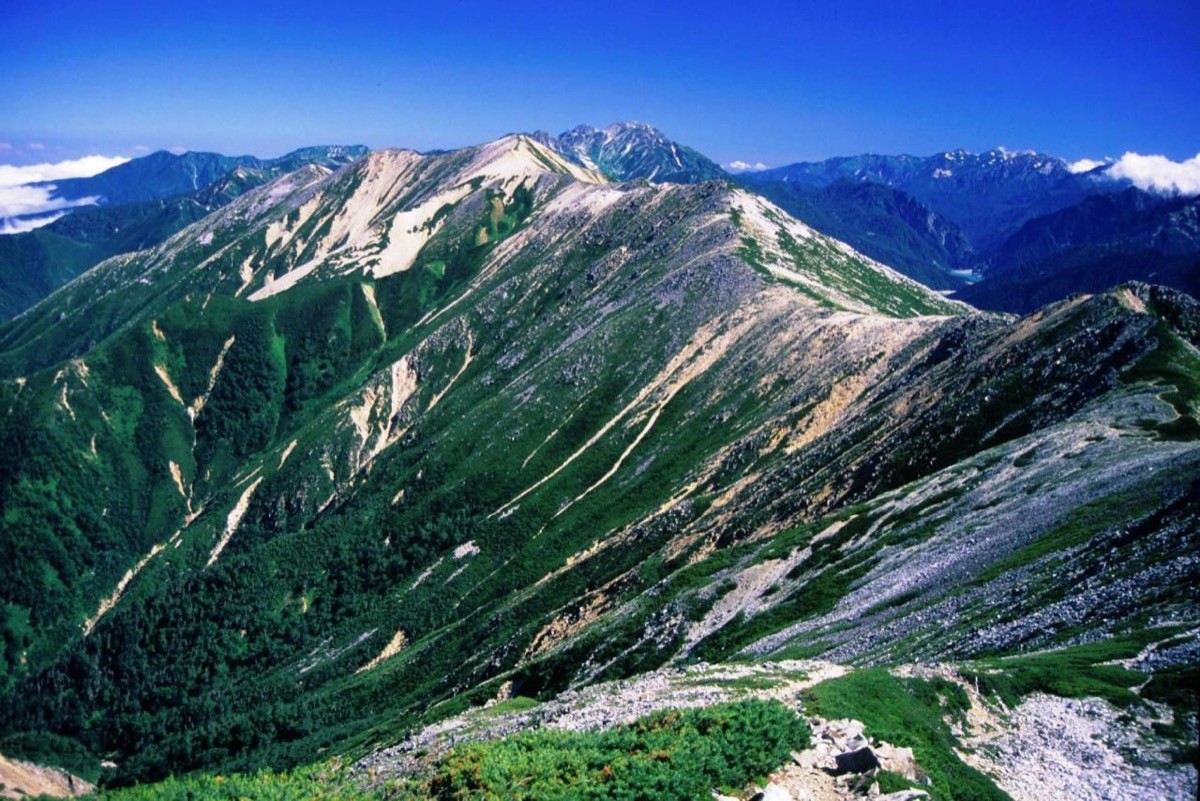
Mt. Akaushi (赤牛岳, 2,864 m) in Toyama is one of the 200 Famous Japanese Mountains.
Named for its reddish-brown slopes, it is a hidden peak rising in the deepest North Alps, prized for the quiet, primeval ridge running from Mt. Suisho and the grand view over the Kurobe headwaters. The traverse from Oritate over Kumonodaira and Mt. Suisho to Mt. Akaushi, then down the Yomiuri-shindo to Kurobe Dam, is an advanced route of at least three nights and four days.
The trailhead is Oritate. It is reachable by a summer climbing bus from Toyama Station, and a multi-day plan with hut stays is assumed.
The trailhead is Oritate (trailhead for Mt. Yakushi and Mt. Akaushi, with toilet and campground). The usual route runs Oritate → Tarodaira → Yakushizawa → Kumonodaira → Mt. Suisho → Mt. Akaushi → Yomiuri-shindo → Oku-Kurobe Hut → Taira-no-watashi → Kurobe Dam; it takes over 20 hours of walking with a large elevation gain and requires at least three nights and four days, advanced. An out-and-back to Mt. Akaushi is difficult, so descending the Yomiuri-shindo to Lake Kurobe is usual, and from the Oku-Kurobe Hut you cross to the far shore by the Taira-no-watashi ferry on Lake Kurobe (two runs a day: 10:00 and 14:00). Missing it leaves you with nowhere to stay, so a carefully timed plan is essential.
There is almost no escape route, and huts such as the Suisho Hut and Oku-Kurobe Hut require reservations. The season is mid-July to mid-September.
How to access the trailheads
1. [Round trip] Toyama Station → Oritate (Mt. Akaushi trailhead) / descent to Kurobe Dam
The nearest base is Toyama Station (Hokuriku Shinkansen). From Toyama Station, take the Toyama Chiho Railway direct summer bus to Oritate. It runs by reservation in summer (usually mid-July to September), with a one-way fare of about ¥5,000. Alternatively, take the Toyama Chiho Railway from Dentetsu-Toyama Station to Arimineguchi Station and change there to the summer bus for Oritate.
If you descend the Yomiuri-shindo to Kurobe Dam, it is usual to take the Kanden Tunnel Electric Bus from Kurobe Dam to Ogizawa and exit toward Shinano-Omachi (JR Oito Line). As services are few and by reservation, check the latest operating days, times and bookings in advance.
– Toyama Chiho Railway ticket center (Oritate direct bus reservations) 076-442-8122
Source: [Toyama Chiho Railway summer bus (Arimine line)]
Route and safety notes
Route: Oritate → Tarodaira → Yakushizawa → Kumonodaira → Mt. Suisho → Mt. Akaushi → Yomiuri-shindo → Oku-Kurobe Hut → Taira-no-watashi → Kurobe Dam. It takes over 20 hours of walking, around 30 km, with a large elevation gain, advanced, with at least three nights and four days standard. The ridge from Mt. Suisho to Mt. Akaushi is quiet and primeval.
Taira-no-watashi: from the Oku-Kurobe Hut you cross to the far shore by the Taira-no-watashi ferry on Lake Kurobe. There are two runs a day (10:00 and 14:00), and missing one can strand you, so build a punctual itinerary.
Huts and escape: the Suisho Hut, Oku-Kurobe Hut and others require reservations. As there is almost no escape route, plan within your limits according to weather and condition.
Gear and season: the season is mid-July to mid-September. Weather changes quickly in the alpine zone, so carry warm and rain gear, a map and compass (GPS), and submit a climbing plan. Refill water at the huts.
In an emergency: call 110 (police) or 119 (fire/rescue).
・Toyama City Office 076-431-6111
Photo by Alpsdake / Wikimedia Commons, Public domain
Comments