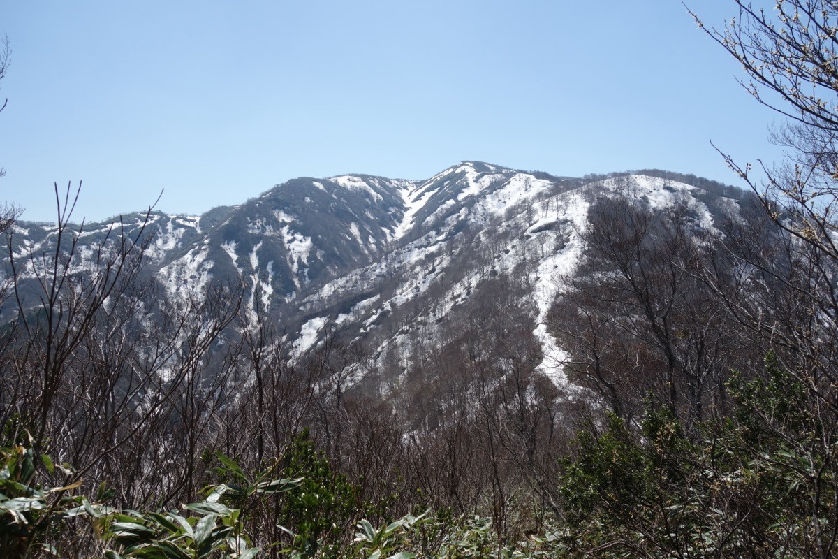
Mt. Kongodo (金剛堂山, 1,650 m), on the border of Nanto and Toyama City in Toyama and Hida in Gifu, is one of the 200 Famous Japanese Mountains.
A high peak of the Hida highlands south of Mt. Shiraki, its appeal is the three peaks of Mae-Kongo, Naka-Kongo and Oku-Kongo, the bamboo meadow and beech forest along the summit ridge, and the 360-degree grand view. It is usually climbed from the Tochitani trailhead in Toga, Nanto, and the classic plan is a day trip out and back to Mt. Kongodo from the Tochitani trailhead.
For public transport to the trailhead, take a Nanto City bus from Ecchu-Yatsuo Station on the JR Takayama Line to Toga, then a taxi to the Tochitani trailhead.
The trailhead is the Tochitani trailhead (about 780 m), with a car park (about 20–30 cars), a toilet and an emergency hut. The standard route is Tochitani trailhead → Mt. Kataori → Mae-Kongo (the survey point) → Naka-Kongo, out and back, with a standard time of about 5 hours, an intermediate route. Beyond the beech forest, the summit ridge is an open bamboo meadow with a grand view, reaching as far as Hakusan and the Northern Alps.
Every year there is a mountain-opening in late May (31 May in 2026), and the best season is early summer to October. The summit meadow can be hard to navigate in fog, so beware of sudden weather changes. Always check the latest trail and road conditions in advance.
*Last checked: June 6, 2026
How to access the trailheads
1. [Round trip] Ecchu-Yatsuo Station → Toga → Tochitani trailhead
The base is Ecchu-Yatsuo Station on the JR Takayama Line. To the Tochitani trailhead you change from a bus to a taxi.
① Ecchu-Yatsuo Station → Toga (Nanto City bus)
Take a Nanto City bus toward Toga from Ecchu-Yatsuo Station and get off at Gassho Culture Village, about 1 hour. There are few services, so check the latest times on Nanto City’s official guide.
② Toga → Tochitani trailhead (taxi)
From Toga to the Tochitani trailhead, use a taxi. As services are few, going straight by taxi from Johana or Tonami Station is also reliable. Mobile reception is poor at the trailhead, so booking both ways in advance is recommended.
― Johana Taxi 0763-62-0046
― Tonami Kanko Kotsu (Nanto) 0763-82-5577
Overnight / by car: In Toga, work on the Toga Dam continues, and the former overnight base, Tenjiku Onsen-no-Sato, is closed. For an overnight stay, inns toward Johana or Toyama are convenient. By car it is about 1 hour from the Tonami IC on the Hokuriku Expressway, with parking at the Tochitani trailhead. For the latest road conditions, check with Nanto City (0763-23-2037).
Source: [Tabi-Nanto (Nanto City tourism)] / [YAMAP, Tochitani trailhead]
Route and safety notes
Route: Tochitani trailhead → Mt. Kataori → Mae-Kongo (1,638 m, survey point) → Naka-Kongo (1,650 m), out and back. The standard time is about 5 hours, an intermediate route. From Mae-Kongo a bamboo-meadow ridge continues toward Oku-Kongo, with views as far as Hakusan, the Northern Alps and the Noto Peninsula.
Beech forest and meadow: From the trailhead a climb through beech forest continues, and the summit meadow can be hard to follow in fog. On days of poor visibility, check your position with a map and GPS, and do not overdo it.
Road and facilities: The Toga area has a Toga Dam construction zone, and road conditions can change. Check passability in advance, not only for the day. There is an emergency hut at the Tochitani trailhead.
Water, season and emergencies: As reliable water sources are few, carry plenty of water. The best season is late May to October. Do not forget rain gear, warm clothing, a headlamp and a map/GPS.
Emergencies: In an accident or emergency, call 110 (police) or 119 (fire/rescue).
・Nanto Police Station 0763-52-0110
Photo by Koda6029 / Wikimedia Commons, CC BY-SA 4.0

Comments