
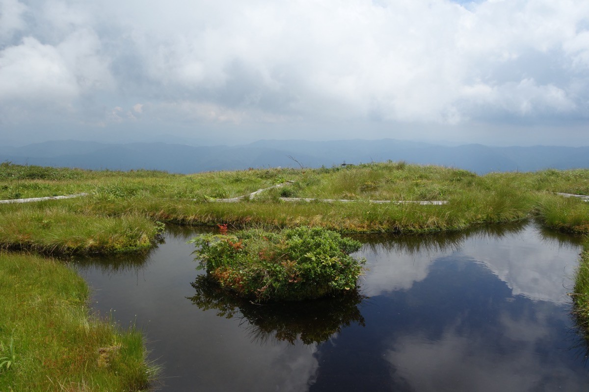
Mount Shirakimine (Shirakimine, 1,596 m) sits on the border of Toyama City in Toyama and Hida City in Gifu, and is one of Japan’s 300 Famous Mountains.
Known for its gentle grassland summit dotted with ponds, its appeal lies in the great colonies of nikkō-kisuge day-lilies in July and the 360-degree view of the Northern Alps and Mount Haku. From the eighth-station parking lot on the Toyama side it is about 40 to 50 minutes on foot to the summit, an easy climb.
There is no direct bus to the trailhead, so you reach it by combining a taxi from Etchū-Yatsuo Station on the JR Takayama Line.
The Toyama-side trailhead is the eighth-station parking lot (Ōnagatani) on the Ōtani forest road, close to the summit. The main route is the eighth-station parking lot → Mount Shirakimine (1,596 m) and back, about 40 to 50 minutes on foot (60 to 75 minutes via the management road), an easy route. The summit is open grassland dotted with ponds such as the Floating Island Pond, with wide views of the Northern Alps and Mount Haku.
The best season is early summer to autumn (June–October), with cotton grass and nikkō-kisuge at their best from mid-June to late July. As the forest road’s status changes easily, always check the latest road conditions and arrange a taxi before you go.
*Last checked: June 7, 2026
How to access the trailheads
1. [There & Back] Etchū-Yatsuo Station ⇄ the eighth-station parking lot (Takayama Line + taxi)
Etchū-Yatsuo Station on the JR Takayama Line is your base. There is no direct bus to Mount Shirakimine, so take a taxi from the station.
① Etchū-Yatsuo Station → eighth-station parking lot (taxi)
From Etchū-Yatsuo Station, take a taxi via the Ōtani forest road in Ōnagatani to the eighth-station parking lot. As it runs along a mountain forest road, check when you book that the taxi can reach the eighth station.
— Yatsuo Kotsu 076-455-3167 / Futaku Ōsawano Kotsu (dispatch) 076-421-1122.
② Gifu side (Manami): there is also a route of about 3 hours from the Manami trailhead in Miyagawa, Hida City, via Ko-Shirakimine. This is mainly reached by car.
③ Note (forest road and closure): on the Toyama side the gate at the Sugigahira campground is closed by a landslide (no set reopening), so enter the Ōtani forest road via National Route 471. The forest road may close in bad weather, so check the latest information.
By car: there is parking at the eighth station. Access from central Toyama via National Route 471 and the Ōtani forest road.
References: [Mount Shirakimine (Toyama-side hiking info)] / [Mount Shirakimine (Yamakei Online)]
Trail Guide and Safety Notes
Route: on the Toyama side the main route is an out-and-back from the eighth-station parking lot to the summit (1,596 m), about 40 to 50 minutes on foot, an easy route. From the Manami trailhead on the Gifu side it is about 3 hours via Ko-Shirakimine, an intermediate route. The summit has boardwalks for touring the ponds and grassland.
Grassland and weather: the summit is treeless grassland, exposed to strong wind, mist and lightning, so take care in bad weather. To protect the wetland, stay on the boardwalk. The forest road may close due to rockfall or lingering snow.
Views and flowers: from the summit there is a panorama of the Northern Alps (Mount Yakushi, Mount Tsurugi), Mount Ontake and Mount Haku. Several ponds such as the Floating Island Pond dot the area, and in July nikkō-kisuge, cotton grass and false hellebore colour the grassland.
Equipment and emergencies: carry rain gear, warm clothing, a headlamp, a map/GPS, plenty of food and water. In an accident or emergency call 110 (police) or 119 (fire/ambulance).
・Toyama-Minami Police Station 076-468-0110
Photo by Koda6029 / Wikimedia Commons, CC BY-SA 4.0
Comments