Mt. Hayachine (早池峰山, 1,917 m) is the highest peak in the Kitakami mountains, straddling Hanamaki, Miyako and Tōno in Iwate Prefecture. Famous for the endemic Hayachine-usuyukisō (late-July bloom), it is a “100 Famous Flower Mountains of Japan” peak and one of Kyūya Fukada’s 100 Famous Mountains.
Within Hayachine Quasi-National Park, the mountain’s serpentinite ridges and rich alpine flora (200+ species, with many endemics like Nanbu-toranō and Nanbu-inu-nazuna) make it the “flower mountain”. The standard Odagoe course is ~700 m gain / ~5:30 round trip, intermediate, and one of Tōhoku’s most renowned flower mountains.
How to access the trailheads
- [Round trip] Shin-Hanamaki Station ⇔ Take / Odagoe (Iwate Kenkō Bus + shuttle)
- Odagoe course, trail overview, suggested plans, emergency contacts
Standard times (Odagoe course, out-and-back, intermediate, ~5:30, ~700 m gain, ~8 km)
Odagoe trailhead (1,240 m) → (30 min) → 1st station (Okanazō below, water) → (1 hr 30 min) → 5th station Okanazō (1,700 m) → (1 hr) → Mt. Hayachine summit (1,917 m, summit emergency hut) → (2 hr 30 min) → Odagoe trailhead
1. [Round trip] Shin-Hanamaki Station ⇔ Take / Odagoe (Iwate Kenkō Bus + shuttle)
From Shin-Hanamaki Station to the trailhead, Iwate Kenkō Bus runs via Ōhasama to Take or Kawaranobō (1 run/day, about 1 h 25 min, ~¥1,200). On car-restriction days (weekends and holidays 14 Jun – 2 Aug 2026), a direct bus from Hanamaki Station to Odagoe (reservation-only) is also available, and a Take ~ Odagoe ~ Etsunagi shuttle bus (restriction days only, ~¥800) connects to Odagoe. From Kawaranobō to Odagoe on foot is about 40–50 min.
Operating period : Iwate Kenkō Bus year round (1 run/day) / shuttle bus on weekends & holidays 2nd Sun of Jun – 1st Sun of Aug / direct bus reservation-only on restriction days
Travel time : Shin-Hanamaki Station → Kawaranobō / Take about 1 h 25 min / Take → Odagoe shuttle about 30 min
Fare : Shin-Hanamaki Station → Ōhasama BT / Take ~¥1,200 / Take ~ Odagoe shuttle ~¥800 / direct bus: confirm at reservation
Frequency : usual route 1 run/day (morning departure)
Shin-Hanamaki Station → Kawaranobō / Take (Iwate Kenkō Bus, hiker excerpt, dates vary by year)
| Shin-Hanamaki Station dep. | Kawaranobō arr. | Take arr. |
|---|---|---|
| around 8:30 (climbing season) | around 9:55 | around 10:05 |
Take / Kawaranobō → Shin-Hanamaki Station (Iwate Kenkō Bus, return)
| Take dep. | Kawaranobō via | Shin-Hanamaki Station arr. |
|---|---|---|
| around 15:30 | around 15:40 | around 17:00 |
Note : Runs are very limited (only 1 a day, so a morning + afternoon pair is the realistic option). On car-restriction days (weekends & holidays 14 Jun – 2 Aug), the direct bus to Odagoe (reservation-only) from Hanamaki Station is recommended; on weekdays, a private car or a taxi from Shin-Hanamaki Station to Kawaranobō (~1 h 25 min, ~¥18,000) is also possible.
Reference : Hanamaki Tourism Mt. Hayachine | Hanamaki City Hayachine Quasi-NP
Inquiries : Iwate Kenkō Bus Hanamaki ☎0198-23-1020 / Hanamaki Tourism Association ☎0198-29-4522
2. Odagoe course, trail overview, suggested plans, emergency contacts
About Mt. Hayachine
The highest peak in central Iwate’s Kitakami mountains (1,917 m), in Hayachine Quasi-National Park. With serpentinite ridges and 200+ alpine species (many endemics), it is regarded as one of Tōhoku’s finest flower mountains. Fukada selected it as a representative “flower mountain” in his 100 Famous Mountains, and Sumie Tanaka included it in “New 100 Famous Flower Mountains”. The endemics — Hayachine-usuyukisō (late July), Nanbu-toranō, Nanbu-inu-nazuna — are seen only here.
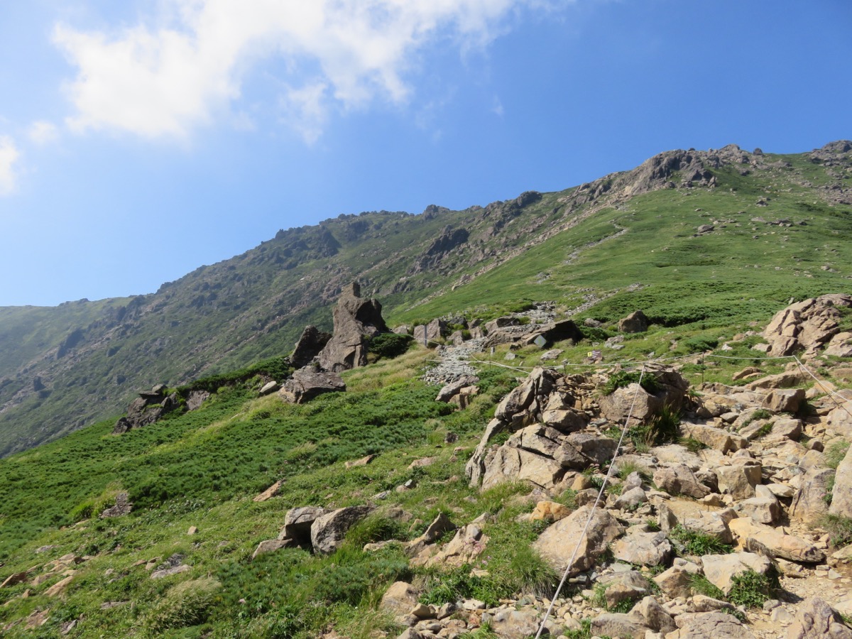
Trail summary (only Odagoe course currently open)
- Odagoe course (intermediate, ~5:30): Odagoe trailhead (1,240 m) → 5th-station Okanazō → summit out-and-back. Steep serpentinite rock, rich in endemics
- Kawaranobō course (⛔closed since May 2016): landslide, indefinite closure
- Monma course (advanced, long): from Miyako side, for fit hikers
Huts, toilets, hot springs
– Mt. Hayachine summit emergency hut (1,917 m): unstaffed, emergency use, toilet (mobile-toilet recommended)
– Odagoe trailhead: toilets available, no parking
– Kawaranobō trailhead: toilets and parking; rest house closed for repairs 15 Jun – late Oct 2026
– Water: one source near 1st station (boil before drinking); carry at least 2 L
– Hayachine to Kenji Observation Spot (Ōhasama, bath ¥500, convenient after descent)
Climbing season and endemics: mid-June to mid-October. Late July is peak for Hayachine-usuyukisō and the high season. Autumn colours mid-September to late September. Residual snow until early June.
Cautions
– Serpentinite is extremely slippery when wet: postpone if rain is forecast
– Do not leave the trail (alpine flower preservation): take photos from the trail
– Car restrictions (weekends & holidays 14 Jun – 2 Aug): park at Take and use the shuttle
– Kawaranobō course remains closed: Odagoe out-and-back only
– Bear sightings: carry bells; spruce and oak forests are rich in bear food
Emergency contacts and inquiries
- Hanamaki City Ōhasama Branch (Ōhasama, Take side): ☎0198-48-2111 / Hanamaki Tourism Association: ☎0198-29-4522
- Tōno City Hall (Monma course): ☎0198-62-2111 / Miyako City Hall (Monma course): ☎0193-62-2111
- Hanamaki Police Station (climbing plan, mountain rescue): ☎0198-23-0110
- Iwate Kenkō Bus Hanamaki Office: ☎0198-23-1020 / Hayachine Lodge Hōnanso (Ōhasama lodging): ☎0198-48-3522
Suggested plans
- Day hike, Odagoe course (intermediate, most popular): Shin-Hanamaki Station 8:30 → Iwate Kenkō Bus → Kawaranobō 9:55 → walk → Odagoe 10:35 → summit 12:30 → descend → Odagoe 14:30 → walk / shuttle → Kawaranobō 15:30 → Iwate Kenkō Bus → Shin-Hanamaki 17:00. ~9 hours
- One night, Ōhasama overnight (recommended, July flower season): Day 1 Shin-Hanamaki → Ōhasama (lodging at Hayachine Lodge Hōnanso etc.). Day 2 early-morning taxi to Odagoe → summit → descend → bathe at Hayachine to Kenji Observation Spot → return
Reference : Hanamaki City Hayachine Quasi-NP | Iwate Pref. Mt. Hayachine climbing info
Photo by Qwert1234
Comments