Contents

Mt. Sennokura

2,026m · Gunma

Timetable checked 2026/05/30
Mt. Sennokura2,026 mGunma
🚃 Reachable by public transport · Day trip · Intermediate · for reasonably fit hikers
Access ease Easy First bus reaches trailhead by 6:09, No transfers
Gateway station Echigo-Yuzawa Station  →  Trailhead Hirao Trailhead
1 public-transport routes ・ Station→trailhead approx. 38 min
Intermediate
Stamina4/10
TechnicalC rocky sections / chains
Trail time 8h 26mestimated
More figures and data sources
Distance 13.96 kmmeasuredTotal ascent ↑1,311 mmeasuredHighest point 2,026 m
📍 Distance, ascent and trail time are for the route shown on the map.
🌸 Best season: Jun, Oct bk🏠 Mountain huts, Water source, Toilets, Hot spring nearby
“bk” = data from books (being replaced with our own measurements). Distance, ascent and trail time are measured/estimated from the map route.

Mt. Sennokura (仙ノ倉山) is a 2026m peak straddling Gunma and Niigata Prefectures, and the highest peak of the Tanigawa Range.

Its mountain form is gentle with continuous flower fields, blessed with views, and selected as one of the 200 Famous Japanese Mountains.
For climbing routes, in addition to the traverse along the Joetsu border ridge from Kata-no-Koya hut of Mt. Tanigawa via Mt. Mantaro, you can also enter from Tairappyo Trailhead at Motohashi in Yuzawa Town on Route 17 via Mt. Tairappyo.

Here we introduce access to the Tairappyo Trailhead bus stop and the timetable.

*Timetable last checked: May 30, 2026

How to access the trailheads

  1. [Outbound] Echigo-Yuzawa Station → Tairappyo Trailhead
  2. [Return] Tairappyo Trailhead → Echigo-Yuzawa Station

Hiking Course Details — Mt. Sennokura

Click to show current location.
Click for full-screen view.

Map & Recommended Route — Mt. Sennokura

Mt. Sennokura — Reference Hiking Times

Standard pace; times rounded to 5 min
SegmentDistanceAscent/DescentForwardReverse
Tairappo Trailhead Bus Stop → Tairappo Mountain Hut4.9 km+678 m / −0 m2:252:10
Tairappo Mountain Hut → Mt. Sennokura3.0 km+488 m / −116 m1:551:40
Mt. Sennokura → Tairappo Trailhead Bus Stop6.0 km+144 m / −1191 m4:054:00
Total14.0 km+1311 m / −1307 m8:257:50

1. [Outbound] Echigo-Yuzawa Station → Tairappyo Trailhead

From JR Joetsu Shinkansen Echigo-Yuzawa Station, board the Minami-Echigo Kotsu Bus “Yuzawa ~ Mitsumata ~ Kaikake Onsen ~ Asakai ~ Seibu Crystal Line” and get off at Tairappyo Trailhead

Travel time: 34 minutes
Fare: ¥610

Bus TimetableEchigo-Yuzawa Station → Tairappyo Trailhead Bus Timetable

Weekdays
Echigo-Yuzawa Station Dep.Tairappyo Trailhead Arr.
5:356:09
8:208:54
9:4010:14
11:5012:24
13:1013:44
15:3016:04
17:1517:49
18:4019:14
Weekends & Holidays
Echigo-Yuzawa Station Dep.Tairappyo Trailhead Arr.
5:356:09
8:208:54
9:4010:14
10:3511:09
11:5012:24
13:1013:44
15:3016:04
17:1517:49
18:4019:14

Reference: [NAVITIME]

2. [Return] Tairappyo Trailhead → Echigo-Yuzawa Station

From Tairappyo Trailhead, board the Minami-Echigo Kotsu Bus “Yuzawa ~ Mitsumata ~ Kaikake Onsen ~ Asakai ~ Seibu Crystal Line” and get off at the terminus, JR Joetsu Shinkansen Echigo-Yuzawa Station

Travel time: 38 minutes
Fare: ¥610

Bus TimetableTairappyo Trailhead → Echigo-Yuzawa Station Bus Timetable

Weekdays
Tairappyo Trailhead Dep.Echigo-Yuzawa Station Arr.
6:257:03
9:3010:08
10:5011:28
13:0013:38
14:2014:58
16:5517:33
18:2519:03
19:4220:20
Weekends & Holidays
Tairappyo Trailhead Dep.Echigo-Yuzawa Station Arr.
6:257:03
9:3010:08
10:5011:28
11:4512:23
13:0013:38
14:2014:58
16:5517:33
18:2519:03
19:4220:20

Reference: [NAVITIME]

Sennokurayama Trail Guide: Route, Difficulty and Best Season

Sennokurayama is the highest peak of the Tanigawa Range, and the ridgeline running from Mt. Tairappyo is lined with alpine flower meadows. The classic outing is a loop from the Tairappyo trailhead, climbing over Matsudeyama and Mt. Tairappyo to the summit and descending via the Hiramoto Shindo trail past the Tairappyo-sanno-ie hut.

Main route

  • Tairappyo trailhead → Matsudeyama → Mt. Tairappyo → Sennokurayama loop (descent via the Hiramoto Shindo trail and the Tairappyo-sanno-ie hut)
  • Distance about 14 km / total ascent about 1,311 m / walking time about 8.5 hours
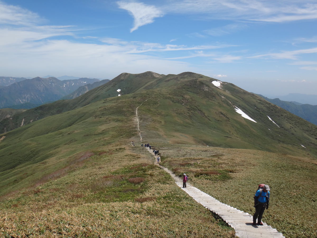
  • Physically demanding, but a well-maintained regular trail with few technical hazards (wooden steps in place)

Difficulty and fitness

The long loop takes some stamina, but there are few technical spots such as chained sections; it is a well-graded trail with wooden steps for much of the way. The ridge between Mt. Tairappyo and Sennokurayama is fully exposed, so take care in strong winds.

Best season

Late June to July, when the alpine flower meadows are at their peak, and late September to early October for the autumn colours are especially rewarding. Watch for lingering snow until around early June and for strong winds along the ridge.

Highlights

The main draws are the flower meadows along the Mt. Tairappyo–Sennokurayama ridge (Hakusan-ichige, Hakusan-kozakura and others), the sweeping views of the Tanigawa Range and the Joshinetsu mountains, and the Tairappyo-sanno-ie hut, a handy spot to rest and refill water.

Photo byWikipedia

Your next mountain

Mt. Azumaya 100 Famous Mountains
IntermediateEasyDay tripTrail time 9h 0017.52 km
Mt. Azumaya 100 Mountains of Gunma
IntermediateModerateDay tripTrail time 9h 1919.92 km

One of Japan's 100 Famous Mountains with a gentle summit and 360-degree views, linked to Nekodake by a wildflower-laden ridge.

Mt. Kasamaruyama 100 Mountains of Gunma
IntermediateModerateDay tripTrail time 4h 3510.5 km
Mt. Monogatariyama 100 Mountains of Gunma
IntermediateModerateDay tripTrail time 3h 557.5 km

Climbed it? Stamp your logbook