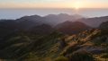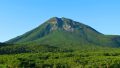
Mt. Shari (斜里岳, 1,547m) is an independent peak in eastern Hokkaido at the base of the Shiretoko Peninsula, also known by the Ainu name “Onnenupuri” (the Great Mountain) — #3 of the 100 Famous Japanese Mountains. The Old Route follows a ravine and passes over more than 10 waterfalls for a varied stream-climbing experience, while the New Route is a ridge route with excellent views. From the summit you gain a grand panorama of the Sea of Okhotsk and the Shiretoko Range — one of Hokkaido’s finest peaks.
*Timetable last checked: May 17, 2026
How to access the trailheads
- [Outbound] Tokyo / Sapporo → Kiyosato-cho Station (JR Senmo Main Line)
- [Outbound] Kiyosato-cho Station → Seigakuso Trailhead (taxi)
- [Return] Seigakuso Trailhead → Kiyosato-cho Station (taxi)
Hiking Course Details — Mt. Shari
Click to show current location.
Click for full-screen view.
*If the map does not appear, please click here.*
Map & Recommended Route — Mt. Shari
Estimated Trail Time (Old Route up / New Route down loop, intermediate, about 7 hours 30 minutes)
Seigakuso (660m) → (40 min) → Shimo-Futamata → (1 hr 30 min) → (Old Route stream ascent, 10+ waterfalls) → Kami-Futamata → (50 min) → Uma-no-Se → (30 min) → Mt. Shari summit (1,547m) → descent (New Route) → (1 hr) → Kami-Futamata → (1 hr) → Shimo-Futamata → (40 min) → Seigakuso
1. [Outbound] Tokyo / Sapporo → Kiyosato-cho Station (JR Senmo Main Line)
To reach Kiyosato-cho Station, the starting point for Mt. Shari, the typical route from Tokyo is New Chitose Airport → Kushiro Station → JR Senmo Main Line, or via Memanbetsu Airport → Shiretoko-Shari Station. From Sapporo, it takes about 6–7 hours by JR limited express plus the Senmo Main Line. Access from Shiretoko-Shari Station is also possible but the taxi ride is longer (40 minutes, about ¥6,000); Kiyosato-cho Station (30 minutes, ¥4,500) is the standard.
JR / airport access reference:
Tokyo Station → New Chitose Airport: about 1 hour 30 minutes by plane, ¥30,000-45,000
New Chitose Airport → Kushiro Station: JR Limited Express Ozora about 4 hours / plane about 50 minutes, ¥18,000-25,000
Kushiro Station → Kiyosato-cho Station: JR Senmo Main Line about 2 hours, ¥1,910
Memanbetsu Airport → Kiyosato-cho Station: bus + JR about 1 hour 30 minutes
Reference: JR Hokkaido | Kiyosato-cho Tourist Association
Inquiries: JR Hokkaido Telephone Information Center ☎011-222-7111 / Kiyosato-cho Tourist Association ☎0152-25-4111
2. [Outbound] Kiyosato-cho Station → Seigakuso Trailhead (taxi)
To reach Seigakuso (elevation 660m), the Mt. Shari trailhead lodge, takes about 30 minutes by taxi from Kiyosato-cho Station at around ¥4,500 (one-way reference). There is no local bus service. Kiyosato Hire is the only taxi operator and advance reservation is essential (especially during the peak July–September season). Many climbers stay at Seigakuso (¥3,500, summer operation, reservation required) the night before and start at dawn. By private car, take National Route 391 via Kiyosato to the Seigakuso parking lot (free, about 30 spaces; frequently full in summer).
Access reference:
Kiyosato-cho Station → Seigakuso: taxi about 30 minutes, around ¥4,500 (one way)
Round-trip duration: Mt. Shari summit loop about 7 hours 30 minutes
Elevation gain: Seigakuso (660m) → Mt. Shari summit (1,547m) about 887m
Taxi reservation: Kiyosato Hire ☎0152-25-2538 (advance reservation required, peak July–September)
Seigakuso (trailhead lodge) information:
Location: 660m elevation, adjacent to the Seigakuso parking lot
Operating period: late June – late September each year (please confirm in advance)
Lodging fee: ¥3,500 per night (room only) ※please confirm for 2026 season
Reservation: advance reservation required, via Kiyosato-cho Tourist Association
Water and toilets: on-site at Seigakuso
Reference: Kiyosato-cho Tourist Association — Mt. Shari / Seigakuso | Akan-Mashu National Park
Inquiries: Kiyosato Hire ☎0152-25-2538 / Kiyosato-cho Tourist Association ☎0152-25-4111
3. [Return] Seigakuso Trailhead → Kiyosato-cho Station (taxi)
After descent, the return from Seigakuso to Kiyosato-cho Station is the same Kiyosato Hire taxi — about 30 minutes, ¥4,500. A round-trip taxi reservation is the most reliable option (descent time is hard to predict). When reserving, telling them an estimate such as “expected descent around 15:00” is the safe approach. After descent, soak off the day’s sweat at Kiyosato Green Onsen (Kiyosato Town, day-use bathing around ¥500) before heading home.
Access reference:
Seigakuso → Kiyosato-cho Station: taxi about 30 minutes, around ¥4,500 (one way)
Round-trip booking: strongly recommended (descent time hard to predict, same-day requests difficult)
Post-descent hot spring:
Kiyosato Green Onsen (Kiyosato Town), day-use bathing around ¥500
Reference: Kiyosato-cho Tourist Association
Inquiries: Kiyosato Hire ☎0152-25-2538 / Kiyosato-cho Tourist Association ☎0152-25-4111
4. Mt. Shari — climbing overview, routes, recommended plans, emergency contacts
About Mt. Shari
An independent 1,547m peak straddling Shari, Kiyosato, and Shibetsu in Hokkaido. Known in Ainu as “Onnenupuri” (the Great Mountain); within Akan-Mashu National Park and selected as #3 in Fukada Kyuya’s “100 Famous Japanese Mountains.” From the summit a sweeping panorama unfolds of the Sea of Okhotsk, the Shiretoko Range, Lake Mashu, and Mt. Meakan, making it a popular peak in eastern Hokkaido.
Trail overview (2 main routes, standard loop)
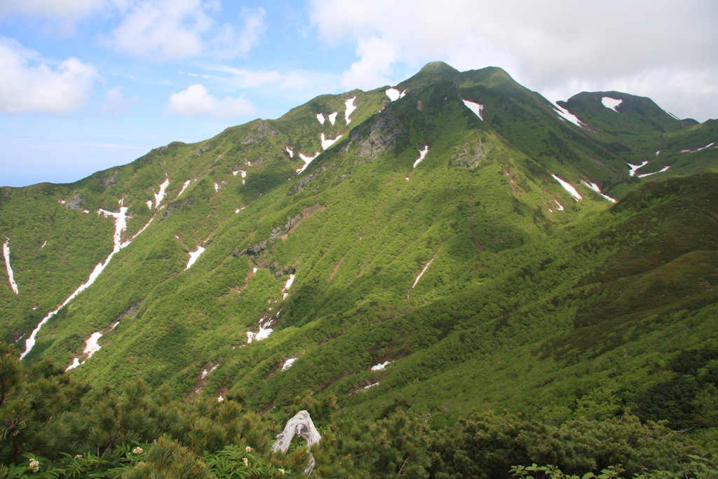
- Old Route (stream climb, intermediate, about 4 hours): Seigakuso → Shimo-Futamata → stream ascent with 10+ waterfalls → Kami-Futamata → Uma-no-Se → summit. A varied stream-climbing experience; difficult to traverse in high water. Stream-climbing shoes recommended.
- New Route (ridge, intermediate, about 3.5 hours): Seigakuso → Shimo-Futamata → New Route (ridge) → Kami-Futamata → Uma-no-Se → summit. Excellent views; the wet-weather choice.
- Standard loop: ascend the Old Route, descend the New Route (about 7 hours 30 minutes, most popular).
Mountain huts and hot springs
– Seigakuso (660m, at the trailhead): ¥3,500/night, room only, summer operation late June – late September, reservation required
– Kiyosato Green Onsen (Kiyosato Town): day-use bathing around ¥500
– Shiretoko side: Utoro / Utoro Onsen, can be combined with Shiretoko sightseeing plans
Climbing season and seasonal information: The standard window is early July to late September. Residual snow in late June; snowfall after October makes the Old Route dangerous. Ezo cowslip, chinguruma, and Shiretoko violets bloom in July. Wildlife: brown bear, pika, Ezo deer.
Cautions
– Old Route involves many stream crossings: difficult in high water; stream-climbing shoes recommended; in rain, switch to an out-and-back on the New Route.
– Taxi essential to Seigakuso: no local bus; advance reservation required.
– Residual snow into early July: consider carrying crampons.
– Many brown bear sightings: carry bear bell and spray, submit a climbing plan.
– Water sources: only stream water (must be boiled); carry at least 2L.
Emergency and inquiry contacts
- Kiyosato Town Office / Tourist Association: ☎0152-25-4111
- Shari Police Station (climbing plan / mountain rescue): ☎0152-23-0110
- Kiyosato Hire: ☎0152-25-2538 / Seigakuso: reservation via Kiyosato-cho Tourist Association
Recommended plans
- 2 days, 1 night — pre-night at Seigakuso + loop day-hike (recommended): Day 1, Kushiro Station → JR Kiyosato-cho Station → taxi → stay at Seigakuso. Day 2, depart 5:00 → Shimo-Futamata → Old Route → summit 9:30 → New Route descent → Seigakuso 13:00 → taxi → Kiyosato-cho Station.
- 3 days, 2 nights — combined with Shiretoko sightseeing: Day 1, stay at Shiretoko Utoro Onsen. Day 2, Utoro → via Kiyosato Town → Seigakuso → climb Mt. Shari. Day 3, Lake Mashu → Lake Akan sightseeing → return.
Reference: Kiyosato-cho Tourist Association | Akan-Mashu National Park
Photo by Σ64 (Wikimedia Commons)