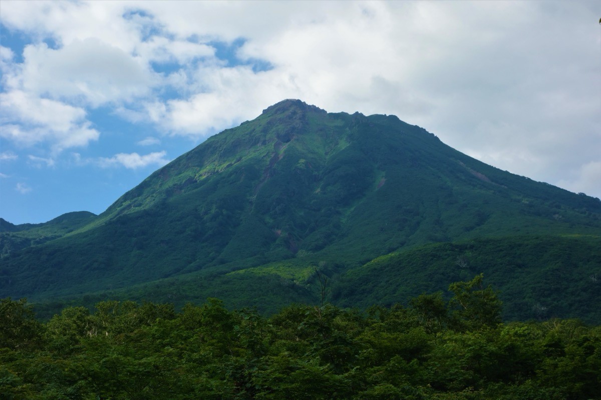
Niigata-Yakeyama (新潟焼山, 2,400 m), straddling Itoigawa and Myoko in Niigata, is one of the 300 Famous Japanese Mountains.
The only active volcano in Niigata, in the Kubiki Mountains, it is a lava-dome peak rising beside Mt. Hiuchi; from the summit you look out over Mt. Hiuchi and the Sea of Japan, and its rugged form, still releasing volcanic steam, is its real charm. The usual route is from the Sasakura and Yakeyama hot springs on the north side: from the trailhead via Tomariiwa it is about 4 hours 20 minutes up and about 3 hours 30 minutes down, a fit-hiker’s intermediate-to-advanced round trip of about 8 hours. As an active volcano, the crater area is restricted according to the volcanic alert level, and entering within a 2 km radius of the summit requires submitting a climbing notification under Niigata Prefecture’s ordinance.
The gateway is Itoigawa Station. There is a route bus from Itoigawa Station to Sasakura Onsen, so it can be approached by public transport.
The climb starts at the Yakeyama trailhead on the north side (beyond Sasakura and Yakeyama hot springs); you climb trailhead → Omagari (about 1 hour) → Tomariiwa (about 2 hours) → summit (about 1 hour 20 minutes), and as the round trip runs about 8 hours an early start is essential. Tomariiwa along the way is a rock shelter usable as a refuge in an emergency. Niigata-Yakeyama is currently at volcanic alert level 1 (be aware it is an active volcano) and you can climb to the summit, but when the level rises the crater area is restricted, so always check the Japan Meteorological Agency and Itoigawa City volcano information before climbing. Entering within a 2 km radius of the summit requires submitting a climbing notification under Niigata Prefecture’s ordinance (there was also a small eruption in May 2016).
You can also traverse from Sasagamine via Mt. Hiuchi, but that is a long route of two days or more. The season is July to October; in the snow-remaining period route-finding across snowfields is needed.
How to access the trailhead
1. [Round trip] Itoigawa Station → Sasakura / Yakeyama Onsen → Yakeyama trailhead
The gateway is Itoigawa Station (Hokuriku Shinkansen / JR Oito Line); take the Itoigawa Bus bound for “Sasakura Onsen” for about 30 minutes (11 round trips a day) and get off at the Sasakura Onsen terminus. From Sasakura and Yakeyama hot springs you follow a forest road to the Yakeyama trailhead (inn shuttles are for guests only and need a reservation, so check your means to the trailhead in advance). Alternatively you can enter Sasagamine from Myokokogen Station and traverse via Mt. Hiuchi, but that is a long route of two days or more.
– Itoigawa Tourism Association 025-555-7344 / Itoigawa Bus 025-552-0180
Source: [Climbing notification for Niigata-Yakeyama (Niigata Prefecture)]
Route and safety notes
Route: Yakeyama trailhead → Omagari → Tomariiwa → Niigata-Yakeyama → return the way you came. About 4 hours 20 minutes up and about 3 hours 30 minutes down, a fit-hiker’s intermediate-to-advanced round trip of about 8 hours. From the summit there is a view of Mt. Hiuchi and the Sea of Japan.
Volcano and restrictions: Niigata-Yakeyama is an active volcano, currently at volcanic alert level 1. When the level rises the crater area is restricted, so always check the Japan Meteorological Agency and Itoigawa City volcano information before climbing. There was a small eruption in May 2016.
Climbing notification (ordinance): entering within a 2 km radius of the summit requires submitting a climbing notification under Niigata Prefecture’s ordinance. Submit it before entering.
Season and gear: the season is July to October; in the snow-remaining period route-finding across snowfields is needed. Carry a map and compass (GPS) and plenty of water, and a helmet too.
In an emergency: in a mishap or accident, call 110 (police) or 119 (fire/rescue).
・Itoigawa City Office 025-552-1511 / Itoigawa Police Station 025-552-0110
Photo by Koda6029 / Wikimedia Commons, CC BY-SA 4.0
Comments