
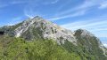
Mt. Iwadono (Iwadonoyama, 岩殿山, 634 m) is a rocky peak in Ōtsuki City, Yamanashi Prefecture. Selected as the eighth of the Twelve Scenic Views of Mt. Fuji from Mt. Hidaka (Shūrei Fugaku Jūnikei), it also encompasses the Sengoku-era “Iwadono Castle Ruins”. Known for being the same height as Tokyo Skytree, the views over Mt. Fuji and the Katsura River valley, together with chain sections and rocky ridges, deliver a remarkably satisfying “rock hike” despite the low elevation.
From JR Chūō Main Line Ōtsuki Station, all trailheads are reachable on foot (15 min minimum).
Due to typhoon damage in 2019, the former main trail from the Maruyama Park / Fureai-no-Yakata side (closest to Ōtsuki Station) up to the summit remains closed long-term. The standard approaches today are the Hatakura trailhead (north side, shortest) or the Asari trailhead (southwest, via the Chigo-otoshi cliff). Some sections around the “Kabuto-iwa 2nd chain section” require taking the bypass trail. Always check the latest status with Ōtsuki City Tourism before heading out.
Iwadono is listed in the Twelve Scenic Views of Mt. Fuji, the New 100 Famous Japanese Mountains, the 100 Famous Mountains of Yamanashi, the 100 Famous Mountains of Kōshin’etsu, and the 300 Famous Japanese Mountains. All access is on foot from JR Chūō Main Line Ōtsuki Station, with limited-express service from Shinjuku taking about 1 hour 5 minutes.
How to access the trailheads
- [Outbound] Ōtsuki Station → Hatakura trailhead (north route)
- [Outbound] Ōtsuki Station → Asari trailhead (Chigo-otoshi loop start)
- [Return] Descent → Ōtsuki Station
- Recommended plans and trail-area info
Hiking Course Details — Mt. Iwadono
Click to show current location.
Click for full-screen view.
*If the map does not appear, please click here.*
Map & Recommended Route — Mt. Iwadono
1. [Outbound] Ōtsuki Station → Hatakura trailhead (north route)
From the north exit of JR Ōtsuki Station, walk north along National Route 139 to Hatakura trailhead in about 25 minutes (1.7 km). From the trailhead, a stepped forest path reaches the summit in another 45 minutes. This is the shortest option with the least elevation gain (round trip 2.5 hours), best for beginners or short itineraries.
2. [Outbound] Ōtsuki Station → Asari trailhead (Chigo-otoshi loop start)
From Ōtsuki Station, walk northwest along National Route 20 for about 25 minutes (1.6 km) to the trailhead in the Asari hamlet. This is the start of a loop course that passes the 100-meter Chigo-otoshi cliff, then Kabuto-iwa, before reaching the summit. Chains, ropes and ladders are continuous, so beginners should use the northern Hatakura route. Time: Asari trailhead → Chigo-otoshi → summit, about 2 h 20 min.
The route crosses a 100-meter cliff ridge known as “Chigo-otoshi”. At Kabuto-iwa, you climb a near-vertical rock face with chains and ladders, and the slip risk is high when wet or icy — not recommended in such conditions. Gloves and a helmet are recommended. A bypass trail is available at the second chain section.
Reference: Ōtsuki City Tourism — Mt. Iwadono
3. [Return] Descent → Ōtsuki Station
If you descended via Hatakura, retrace your steps to reach Ōtsuki Station in about 25 minutes on foot. If you started from Asari, complete the loop down to the Asari hamlet via the Chigo-otoshi viewpoint, or descend through Hatakura after a summit round trip. Every option converges on Ōtsuki Station.
The downstream (Tokyo-bound) frequency mirrors the inbound: limited-express service runs into the early evening, with the last local train operating in the late evening.
Reference: Yahoo! Transit
4. Recommended plans and trail-area info
Beginner / short plan: Ōtsuki Station → Hatakura trailhead → summit round trip (about 2.5 hours total, no chain sections). Best when you want the Mt. Fuji view alone.
Intermediate loop plan: Ōtsuki Station → Asari trailhead → Chigo-otoshi → Kabuto-iwa → summit → Hatakura trailhead → Ōtsuki Station (about 4 hours, includes chain sections and the cliff ridge). For those who want to enjoy the rock playground feel.
● Water: no water sources on trail. Carry drinking water from around Ōtsuki Station.
● Toilets: at Ōtsuki Station and Iwadono Park. None at the Hatakura or Asari trailheads.
● Onsen after hike: Maki Onsen (15 min by bus from Ōtsuki Station, ¥1,000 bath / ¥200 towel rental).
● Local sake: Sasaichi Sake Brewery (walking distance from Ōtsuki Station, dry sake specialist).
● Emergency contacts: Ōtsuki Police 0554-22-0110 / Ōtsuki City Tourism Division 0554-23-8036.
Photo by Saigen Jiro

Comments