
Mt. Minamikoma (南駒ヶ岳, 2,841 m), on the border of Iijima in Kamiina and Okuwa in Kiso, Nagano, is one of the 200 Famous Japanese Mountains.
In the southern Central Alps, its appeal is the granite rocky ridge running from Mt. Kosumo to Sengaire and the quiet ridge walking with few other hikers. It is usually climbed from the Inagawa Dam on the west side via Kosumo Hut, and the classic plan is an advanced route over Mt. Kosumo and Sengaire to Mt. Minamikoma in two days with one night.
There is no public transport to the trailhead, so a taxi from the nearest station is the norm. The nearest station is Suhara on the JR Chuo Main Line. You reach the Inagawa Dam by taxi from Suhara Station.
The trailhead is the Kosumo trailhead (above Inagawa Dam, about 1,160 m). The standard route is Kosumo trailhead → Fukutochi Bridge → Kosumo Hut (overnight) → Mt. Kosumo → Sengaire → Mt. Minamikoma; the first day to Kosumo Hut takes about 5–6 hours. It cannot be done as a day trip and is an advanced route with one night on the mountain.
The Inagawa forest road has been closed to vehicles below Inagawa Dam since the 2018 storm disaster (no restoration prospect as of 2026), so taxis and cars can only reach below the dam, adding about 1 hour on foot to the trailhead. Also, Kosumo Hut is suspended for the 2026 season (no reopening date), while the adjacent Kosumo emergency hut (unstaffed) is available. The best season is July to early October; take care on the rocky ridge and chains at Sengaire. Always check the latest forest-road, trail and hut conditions in advance.
*Last checked: June 6, 2026
How to access the trailheads
1. [Round trip] Suhara Station → Inagawa Dam → Kosumo trailhead
The base is Suhara Station on the JR Chuo Main Line. There is no local bus to the Kosumo or Minamikoma trailhead, so a taxi or a car is the standard option.
① Suhara Station → below Inagawa Dam (taxi)
From Suhara Station, take a Nagiso Kanko taxi toward Inagawa Dam. The fare is roughly ¥6,000. No taxis wait at Suhara Station, so booking both the outbound and return rides in advance is essential. You can also board at JR Okuwa Station, Nojiri Station or the Okuwa Village Sports Park.
― Nagiso Kanko Taxi 0264-55-4155
② Below Inagawa Dam → Kosumo trailhead (about 1 hour on foot)
The Inagawa forest road has been closed to vehicles below Inagawa Dam since the 2018 storm disaster, and the upper parking is unavailable. Taxis and cars reach only below the dam, and from there it is about 1 hour on foot along the forest road to the Kosumo trailhead. Work back from your descent time and book the pickup taxi with plenty of margin.
Inquiries: For the latest forest-road and trail information, check with the Okuwa Village Industry and Tourism Section (0264-55-3080).
Source: [Okuwa Village, Central Alps hiking] / [Kosumo Hut information]
Route and safety notes
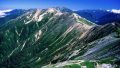
Route: Kosumo trailhead → Fukutochi Bridge → Kosumo Hut → Mt. Kosumo (2,613 m) → Sengaire → Mt. Minamikoma (2,841 m). The first day to Kosumo Hut takes about 5–6 hours, an advanced route with one night on the mountain. From Mt. Kosumo to Mt. Minamikoma a granite rocky ridge continues, with grand views of the Southern Alps and Mt. Ontake.
Rocky ridge and chains: Between Mt. Kosumo and Mt. Minamikoma, Sengaire is a difficult section with chains and loose, rocky ridges. In rain, strong wind or fog the risk of a fall or losing the way rises, so be willing to turn back.
Huts and emergency hut: Kosumo Hut is suspended for the 2026 season (no reopening date). The adjacent Kosumo emergency hut (unstaffed) is available, but bring your own water, food and bedding. Check the latest operating status in advance.
― Kosumo Hut (reservations / status) 090-7699-9337
Gear and season: The best season is July to early October. Carry water, food, rain gear, warm clothing, a headlamp and a map/GPS.
Emergencies: In an accident or emergency, call 110 (police) or 119 (fire/rescue).
・Kiso Police Station 0264-22-0110
Photo by Σ64 / Wikimedia Commons, CC BY-SA 3.0
Comments