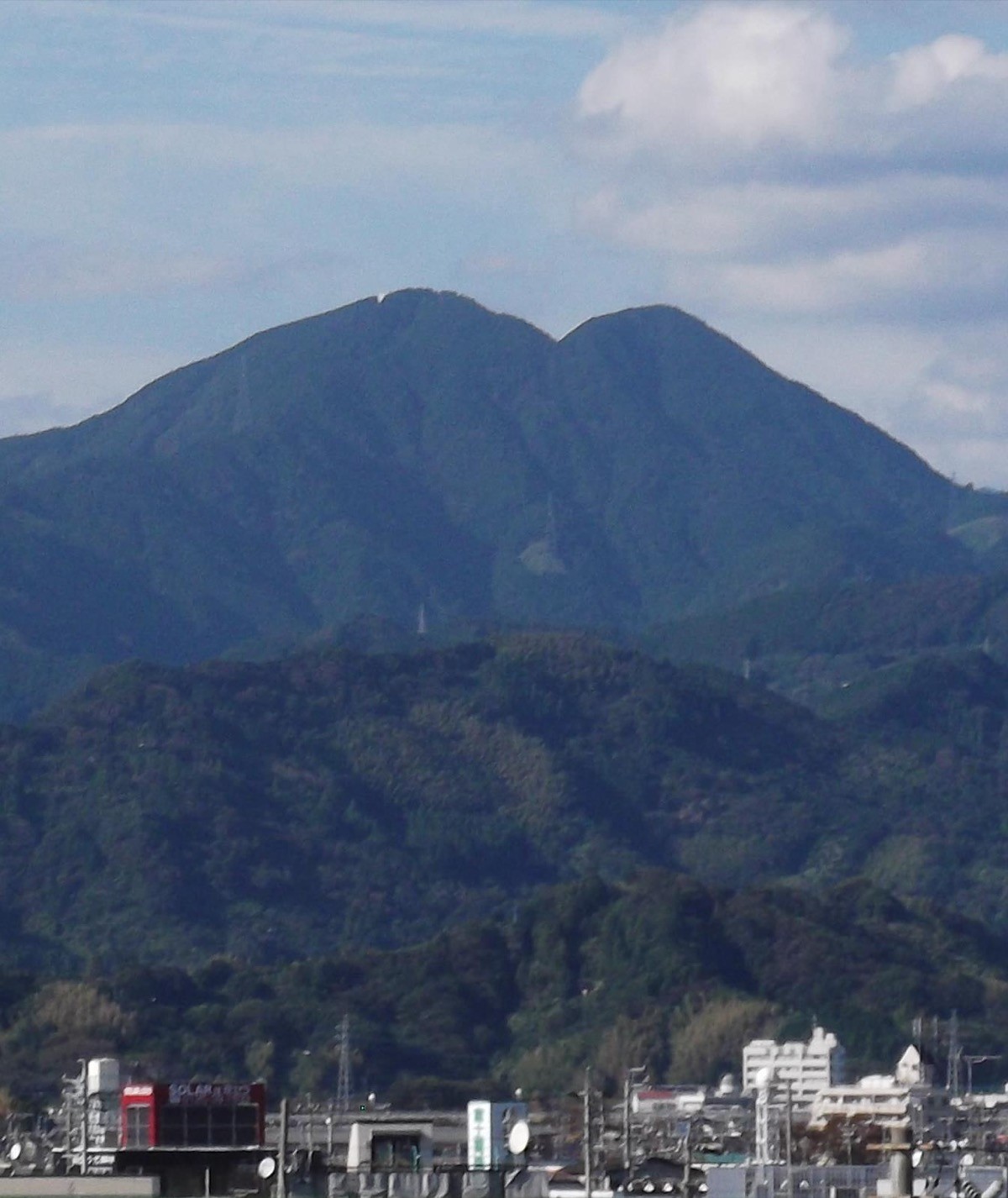
Mount Ryusō (Ryusōzan, 1,051 m) is in Aoi Ward, Shizuoka City, Shizuoka Prefecture, and is one of Japan’s 300 Famous Mountains.
A long-revered mountain at the southern end of the Minobu range, its appeal lies in its twin peaks of Yakushi-dake and Monju-dake, the views of Suruga Bay, Miho-no-Matsubara and the Southern Alps, and the Hozumi Shrine on its slope. A bus from Shizuoka Station reaches the Hirayama trailhead, making it a local mountain you can day-hike by public transport alone.
For access, take a Shizutetsu Just Line bus from JR Shizuoka Station to Hirayama.
The trailhead is the Hirayama trailhead (about 300 m), with parking and toilets nearby. The main route is Hirayama trailhead → Hozumi Shrine → Yakushi-dake (1,051 m) → Monju-dake (1,041 m) and back, an intermediate route with a standard time of about 4–5 hours. You climb along a stream to Hozumi Shrine, and the summits give views of Suruga Bay, Miho-no-Matsubara and the Southern Alps.
The best season is all year (with ice on the summit in winter); for a low mountain it has a good elevation gain and a satisfying climb. Always check the latest bus times and trail conditions before you go.
*Last checked: June 6, 2026
How to access the trailheads
1. [There & Back] Shizuoka Station ⇄ Hirayama (Shizutetsu Just Line)
Shizuoka Station on the JR Tōkaidō Main Line and Shinkansen is your base. Take a Shizutetsu Just Line bus from in front of the station to the Hirayama trailhead.
① Shizuoka Station → Hirayama (Shizutetsu Just Line, Ryusōzan line [61] for Norisawa)
From in front of Shizuoka Station take the Ryusōzan line bound for Norisawa and get off at Hirayama; it takes about 50 minutes. It reaches Hirayama at roughly 8:51, 11:03 and 13:03 (Norisawa-bound). From there you walk to the trailhead.
② Hirayama → Shizuoka Station (return)
Buses back to Shizuoka Station are Hirayama dep. 13:26, 15:26 and 17:22. As services are few, check the times to match your descent.
③ Doing the circuit: you can also descend from Yakushi-dake and Monju-dake toward Norisawa, and return to Shizuoka Station on the Ryusōzan line from Norisawa too.
④ Taxi: as buses are limited, combining a taxi from Shizuoka Station is reliable (about 30 minutes to the Hirayama trailhead).
— Shizutetsu Taxi 054-280-3333
By car: there is parking at the Hirayama trailhead.
References: [Shizutetsu Just Line Ryusōzan line] / [Mount Ryusō]
Trail Guide and Safety Notes
Route: Hirayama trailhead → Kimohiyashi Falls → Hozumi Shrine → Yakushi-dake (1,051 m) → Monju-dake (1,040.8 m) and back. The standard time is about 4–5 hours, an intermediate route. From Hozumi Shrine to Yakushi-dake there are long stone steps and a steep climb. There is also a circuit descending from Monju-dake to Norisawa.
Stream and stone steps: up to Hozumi Shrine the path follows a stream, with bridges and stone steps that get slippery after rain. The steep stone and wooden steps from the shrine have big risers, so climb and descend carefully.
Views and seasons: Monju-dake and Yakushi-dake give views of Suruga Bay, Miho-no-Matsubara and the Southern Alps (Mount Hijiri and Mount Akaishi). It can be climbed all year as a low mountain, but the summit can ice over in winter. Watch for leeches in the wetter summer months.
Equipment and emergencies: carry rain gear, warm clothing, a headlamp, a map/GPS and plenty of food. In an accident or emergency call 110 (police) or 119 (fire/ambulance).
・Shizuoka-Chuo Police Station 054-252-0110
Photo by Halowand / Wikimedia Commons, CC BY-SA 3.0
Comments