Mount Awa (Awagatake, 1,293 m) sits on the border of Kamo City and Sanjō City in Niigata Prefecture, and is one of Japan’s 300 Famous Mountains.
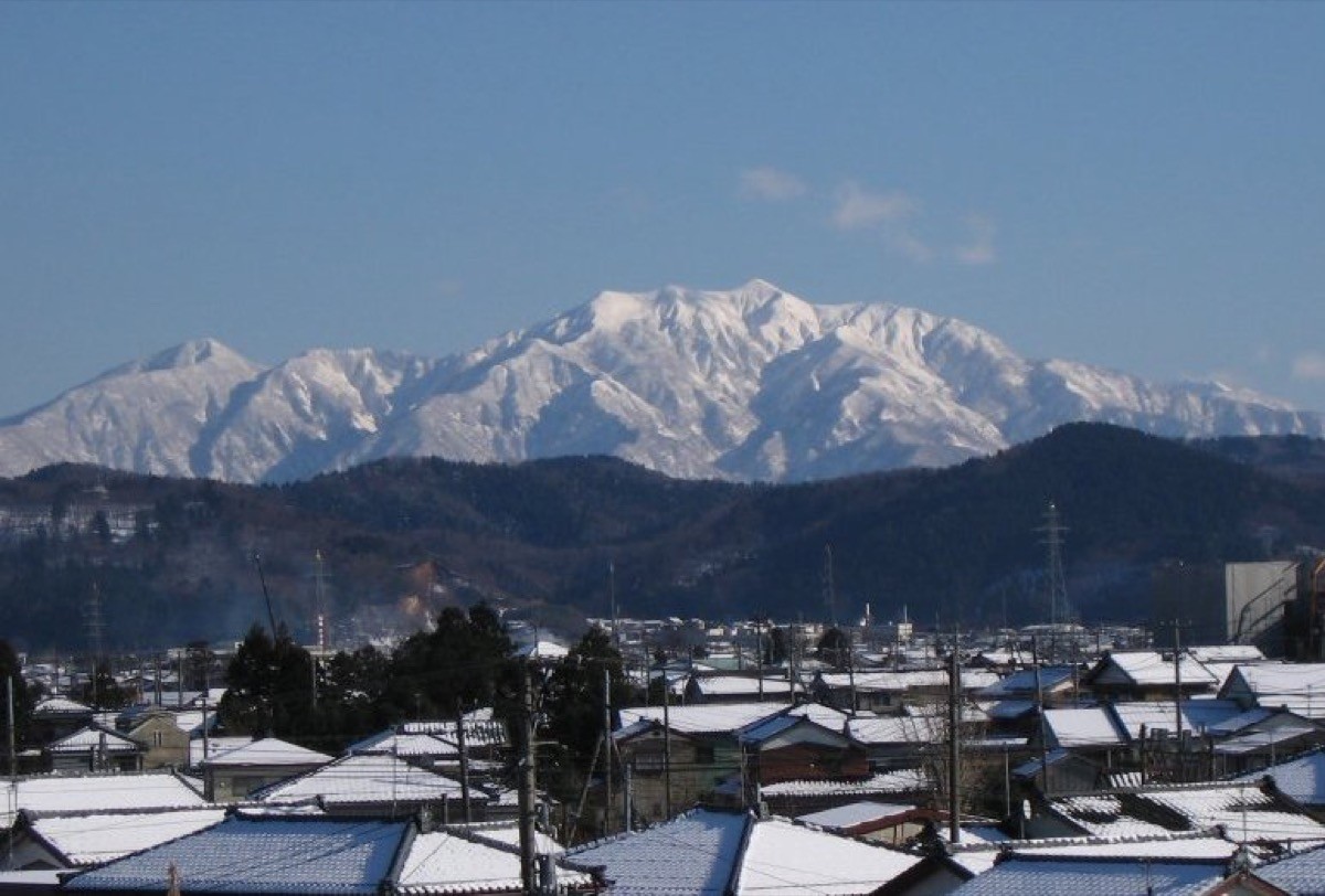
An isolated peak rising east of the Echigo Plain, its appeal lies in the beech forest, the steep ridges, and the views of the Echigo Plain, the Iide range and Mount Sumon from the summit. The usual day hike goes up to the summit and back via the Central Trail (Kamo water-source) on the Kamo City side, a satisfying climb popular as a tough local mountain.
For public-transport access, take a Kamo City bus from JR Kamo Station to Suigenchi (the water source).
The trailhead is the Awagatake Citizens’ Recreation Area, the Second Reservoir (Central Trail trailhead), with parking and toilets. The main route is Second Reservoir → Awagatake Hut → Mount Awa (1,293 m) and back, an intermediate-to-advanced route taking about 4 hours up and 3 hours down. The ridge is a steady steep climb, and the summit gives wide views of the Echigo Plain, the Iide range and Mount Sumon.
The best season is spring to late autumn (April–November) outside the snow season; there is snow in winter. Always check the latest trail and bus times and arrange a taxi before you go.
*Last checked: June 6, 2026
How to access the trailheads
1. [There & Back] Kamo Station ⇄ Suigenchi / Central Trail (Kamo City bus & taxi)
Kamo Station on the JR Shin’etsu Main Line is your base. Take a Kamo City bus from the station to Suigenchi and reach the Central Trail trailhead (Second Reservoir).
① Kamo Station → Suigenchi (Kamo City Bus, Nanaya Line)
From JR Kamo Station take the Kamo City community bus “Nanaya Line” and get off at the Suigenchi stop, about 30 minutes. As services are few, check the latest times with Kamo City (Commerce & Tourism Division 0256-52-0080).
② Suigenchi → Central Trail trailhead (on foot)
The Central Trail trailhead at the Second Reservoir is within walking distance of the Suigenchi bus stop.
③ Taxi
As buses are limited, combining a taxi from Kamo Station is reliable (about 20 minutes to the trailhead).
— Use a taxi from in front of Kamo Station (local Kamo taxi).
④ Return: descend by the same Central Trail. It is reassuring to arrange the bus time or a taxi for your expected descent.
By car: there is parking at the Awagatake Citizens’ Recreation Area / Second Reservoir. It is about 60 minutes from the Sanjō-Tsubame IC on the Hokuriku Expressway.
References: [Kamo City: Mount Awa] / [Niigata Tourism Navi: Mount Awa]
Trail Guide and Safety Notes
Route: the Central Trail is Second Reservoir → Ōtochi-daira → Awagatake Hut → Mount Awa (1,293 m) and back. The standard time is about 4 hours up and 3 hours down, an intermediate-to-advanced route. There is also the Kita-Imogawa course on the Sanjō side. The elevation gain is large, making it a satisfying climb for a local mountain.
Steep climbs and narrow ridges: the Central Trail has steep climbs, narrow ridges and chained sections that are slippery after rain. Use the Awagatake Hut (emergency shelter) mid-route to pace yourself.
Views and seasons: the summit gives wide views of the Echigo Plain, the Iide range, Mount Sumon and the Awagatake ridge. Fresh greenery and autumn colours are lovely, and there is snow in winter when snow gear is needed. Water sources are limited, so carry plenty.
Equipment and emergencies: carry rain gear, warm clothing, a headlamp, a map/GPS and plenty of food and water. In an accident or emergency call 110 (police) or 119 (fire/ambulance).
・Kamo Police Station 0256-52-0110
Photo by Yuniko / Wikimedia Commons, CC BY-SA 3.0

Comments