
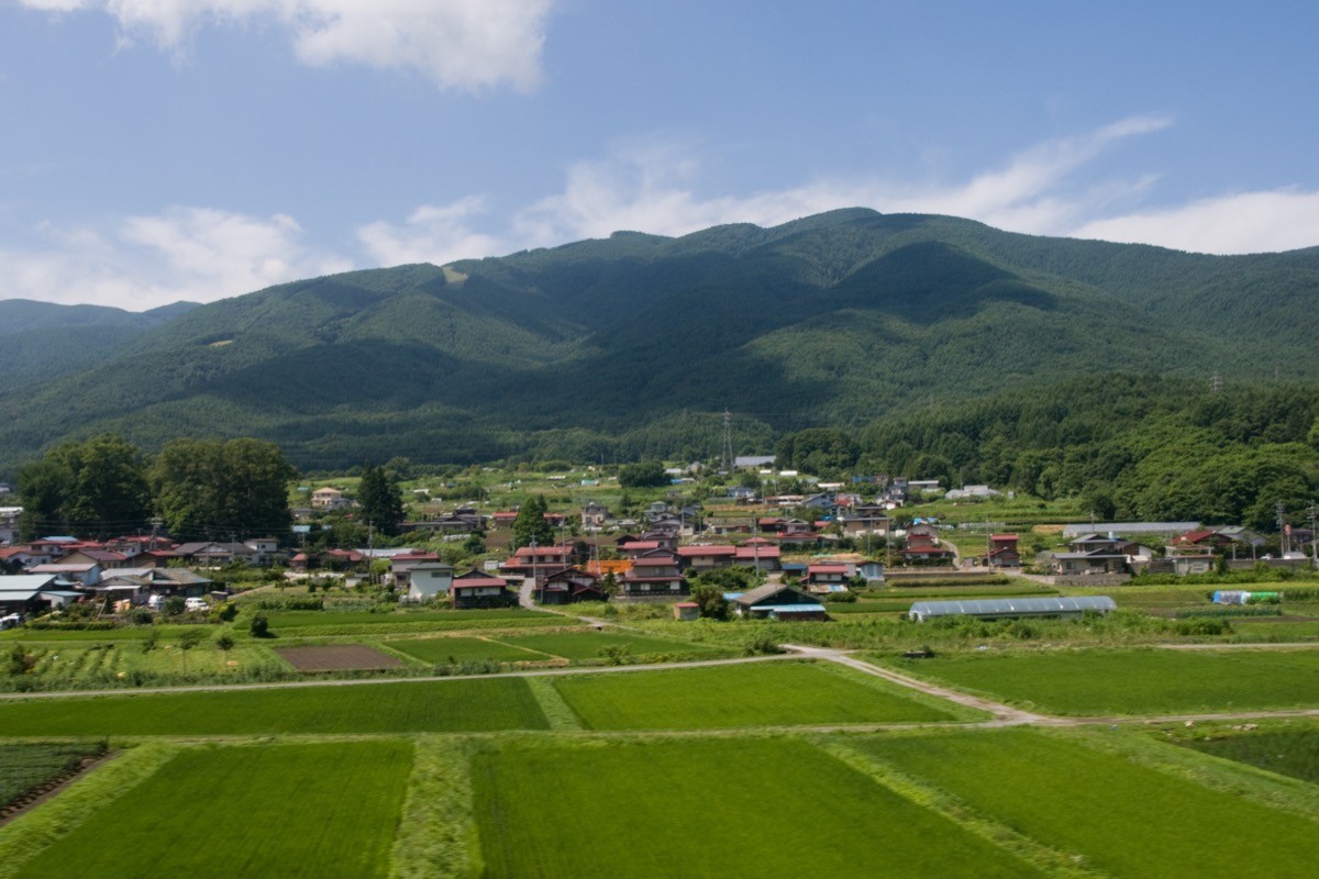
Mount Nyukasa (Nyukasayama, 1,955 m) sits on the border of Ina City and Fujimi Town in Nagano Prefecture, and is one of Japan’s 300 Famous Mountains.
Standing at the northern end of the Southern Alps, its summit gives a 360-degree panorama of the Yatsugatake range, the Northern Alps, Mount Fuji and the main ridge of the Southern Alps, along with the alpine flowers of the Nyukasa marsh and flower fields. Using the gondola at Fujimi Panorama Resort you can rise straight to 1,780 m, leaving an easy hike of about 40 minutes to the summit.
For public-transport access, take the free shuttle bus or a taxi from JR Fujimi Station to Fujimi Panorama Resort.
The trailhead is Fujimi Panorama Resort (gondola base station, about 1,050 m), with a large car park, toilets and a restaurant. Take the “Suzuran” gondola up to the summit station (1,780 m), then summit station → Nyukasa Suzuran Alpine Plant Garden → Nyukasa Marsh → Mount Nyukasa and back, a beginner route of about 1 hour 30 minutes to 2 hours when using the gondola. The summit offers a 360-degree view, and the Nyukasa Marsh has lily of the valley in June and a variety of alpine flowers from spring to autumn.
The best season is late April to November; the gondola and free shuttle bus also run during the green season (roughly late April to November). Always check the latest operating days and times before you go.
*Last checked: June 6, 2026
How to access the trailheads
1. [There & Back] Fujimi Station ⇄ Fujimi Panorama Resort (free shuttle bus & gondola)
Fujimi Station on the JR Chuo Main Line is your base. From the station you reach Fujimi Panorama Resort by free shuttle bus or taxi, then take the gondola to gain height quickly.
① Fujimi Station → Fujimi Panorama Resort (free shuttle bus)
During the green season (roughly late April to November) the free shuttle runs Fujimi Station dep. 9:15 → Resort arr. 9:25 and 10:00 dep. → 10:10 arr. As it runs subject to passenger numbers, check in advance with Fujimi Panorama Resort (0266-62-5666) when you plan to use it.
② “Suzuran” Gondola (base station → summit station)
The gondola runs 8:30–16:00 (last descent 16:30), 1,700 yen round trip. It takes about 10 minutes from the base station (about 1,050 m) to the summit station (1,780 m).
③ Fujimi Panorama Resort → Fujimi Station (free shuttle bus, return)
The shuttle back toward Fujimi Station is roughly Resort dep. 15:00 → Fujimi Station arr. 15:10 (again subject to passenger numbers).
④ Taxi
As the shuttle is limited, combining a taxi from Fujimi Station is reliable (about 10 minutes).
— Alpico Taxi 0266-71-1181
By car: Fujimi Panorama Resort has a free car park (about 1,300 spaces). The forest road from the Sawairi trailhead has private-car restrictions from April to November.
References: [Fujimi Panorama Resort] / [Fujimi Town: Mount Nyukasa]
Trail Guide and Safety Notes
Route: Gondola summit station → Nyukasa Suzuran Alpine Plant Garden → Nyukasa Marsh → Mount Nyukasa (1,955 m) and back. The standard time is about 1 hour 30 minutes to 2 hours, a beginner route. Just below the summit there is a rocky route and a bypass route; families should take the safer bypass. To climb on foot, there are also routes from the Sawairi trailhead and from Suzuran-no-Sato Station.
Protecting the marsh and flower fields: in the Nyukasa Marsh and flower fields, keep to the boardwalks and marked paths to protect the vegetation. Lily of the valley blooms in June, and various alpine flowers from spring to autumn. Always close the deer-fence gates behind you.
Views and seasons: the summit gives a 360-degree view of the Yatsugatake range, the Northern Alps, Mount Fuji and the Southern Alps. At this elevation it stays cool even in summer, while winter brings snow and ice. In winter the gondola switches to ski-resort operation, so check the service status for hiking use.
Equipment and emergencies: carry rain gear, warm clothing, a headlamp, a map/GPS and plenty of food. In an accident or emergency call 110 (police) or 119 (fire/ambulance).
・Suwa Police Station 0266-52-0110
Photo by Σ364 / Wikimedia Commons, CC BY-SA 3.0
Comments