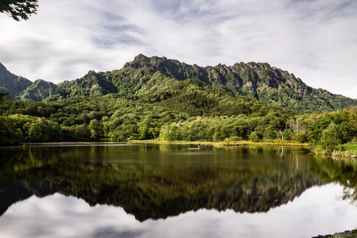
Mt. Togakushi (戸隠山, 1,904 m) in Nagano City, Nagano Prefecture, is one of the 200 Famous Japanese Mountains.
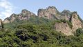
The main peak of the Togakushi range and a long-standing centre of mountain worship, it is known for the knife-edge ridge called Ari-no-towatari (sheer drops on both sides) and continuous chain sections. On Nagano Prefecture’s technical difficulty scale it ranks in the top class (comparable to the Kaerazu Col in the Northern Alps) and is a route for advanced climbers only. It is also listed among the 100 Famous Flower Mountains and the 100 Famous Mountains of Shinshu.
From JR Nagano Station, reach Togakushi-Okusha-iriguchi by the Togakushi Sightseeing Express (reservation-based).
The trailhead is Togakushi Shrine Okusha. From the Togakushi-Okusha-iriguchi bus stop, walk about 2 km (40 min) up the cedar-lined approach to the Okusha. The trail starts beside the shrine and passes the Gojikken-nagaya and Hyakken-nagaya rock shelters and the chains of Munatsuki-iwa, then reaches Ari-no-towatari (the “sword-edge crossing”); from there it crosses Happō-nirami to the summit (1,904 m). The climb takes 2–3 hours, but Ari-no-towatari has drops of hundreds of metres on both sides and a fall there is fatal.
⚠️ Fatal falls have occurred repeatedly at Ari-no-towatari (including a death in October 2023). Do not enter without ample rocky-ridge experience, skill and equipment (helmet essential), and never in bad weather or strong wind. Local authorities recommend going with a mountain guide.
The Togakushi range is a designated area under Nagano Prefecture’s mountain-safety ordinance, so submitting a climbing plan is required. The season is June to October. Note that the Okusha approach and Kagami Pond can be enjoyed by ordinary sightseers (separate from the climb).
How to access the trailheads
- [Outbound] Nagano Station → Togakushi-Okusha-iriguchi
- [Return] Togakushi-Okusha-iriguchi → Nagano Station
1. [Outbound] Nagano Station → Togakushi-Okusha-iriguchi
From JR Nagano Station, take the Togakushi Sightseeing Express (reservation-based) and alight at Togakushi-Okusha-iriguchi.
Ride time: approx. 65 min
Reservation-based (book from one month ahead on Highway-bus.com; boarding without a reservation is possible if seats remain). Departures from Nagano Station run roughly hourly from about 6:50 to 14:10.
※The scheduled “Route 70” local bus mainly serves the Togakushi-Chusha area; the sightseeing express is the reliable way to reach Okusha-iriguchi directly. Sections and times vary by service, so check the latest official Alpico PDF for all departures.
Bus TimetableNagano Station to Togakushi-Okusha-iriguchi (express, reservation)
| Nagano Sta. dep. | Togakushi-Okusha-iriguchi arr. |
|---|---|
| 6:50 | 7:55 |
| 8:50 | 9:55 |
| 12:50 | 13:55 |
Source: [Alpico Kotsu, Togakushi Sightseeing Express]
2. [Return] Togakushi-Okusha-iriguchi → Nagano Station
From Togakushi-Okusha-iriguchi (or the terminus, Togakushi Campground) take the Togakushi Sightseeing Express (reservation-based) and alight at JR Nagano Station.
Ride time: approx. 65 min
The times below are main departures from Togakushi Campground (Okusha-iriguchi is a few minutes later). In the evening, the 16:20 departure (arriving Nagano 17:25) is a guide.
Bus TimetableTogakushi (Campground) to Nagano Station (express, reservation)
| Togakushi Campground dep. | Nagano Sta. arr. |
|---|---|
| 8:15 | 9:20 |
| 12:30 | 13:35 |
| 16:20 | 17:25 |
Source: [Alpico Kotsu, Togakushi Sightseeing Express]
Route and safety notes
Route: Togakushi Shrine Okusha → Gojikken-nagaya and Hyakken-nagaya → Munatsuki-iwa → Ari-no-towatari → Happō-nirami → summit. The usual descent loops via the Ichifudō emergency hut down to Togakushi Farm, about 6 hours in total.
⚠️ Ari-no-towatari (most important): a knife-edge only tens of centimetres wide with drops of hundreds of metres on both sides and continuous chains. It is an extremely dangerous spot where a fall is fatal, and several deaths have occurred. Rocky-ridge experience, skill and equipment (helmet) are essential; beginners, those afraid of heights, and anyone in bad weather must not enter. If unsure, turn back at Munatsuki-iwa.
Climbing plan: The Togakushi range is designated under Nagano Prefecture’s mountain-safety ordinance, so submitting a climbing plan is mandatory (via “Compass” or the Nagano police).
In an emergency: Call 110 (police) or 119 (fire).
・Nagano Chūō Police Station 026-244-0110 / Togakushi police box 026-254-2046
Photo by Big Ben in Japan / Wikimedia Commons, CC BY-SA 2.0
Comments