
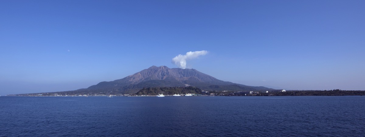
Sakurajima (highest peak Kitadake, 1,117 m) in Kagoshima City, Kagoshima, is one of the 200 Famous Japanese Mountains.
Rising from Kinko Bay and still sending up plumes of smoke, it is one of Japan’s most active volcanoes, and because the area within a 2 km radius of the Minamidake summit crater is a designated warning zone and off-limits, you cannot climb to the summits of Kitadake, Minamidake or Ondake. The highest point the public can reach is the Yunohira Observatory (373 m) at the fourth station of Kitadake, known as the viewpoint that comes closest to the crater. Because the eruption alert level and the restricted area change with volcanic activity, always check the latest information from the Japan Meteorological Agency before approaching.
The hub for access is Sakurajima Port. The basic plan is to cross from Kagoshima Port to Sakurajima Port by the Sakurajima Ferry, then take the Sakurajima Island View bus to the Yunohira Observatory.
Sakurajima is not a mountain you can climb, and entry to the summit and the area around the crater is prohibited. The destination for visitors is the highest publicly accessible point, the Yunohira Observatory (373 m), where the rugged slopes of Kitadake rise right before you and a sweeping panorama of central Kagoshima and Kinko Bay opens up across the water. The observatory is linked to Sakurajima Port by the Sakurajima Island View bus, and the area around the port has plenty to experience, such as the Sakurajima Visitor Center and the Lava Nagisa Promenade. When the eruption alert level is raised, it can affect the observatory and bus services, so check the latest eruption alert level from the Japan Meteorological Agency and the Kagoshima City tourist information before you go. A hat, mask and rain gear are reassuring in case of ashfall.
How to access the Yunohira Observatory
1. [Round trip] Kagoshima Port → Sakurajima Port → Yunohira Observatory (highest public point)
The nearest base is Kagoshima-Chuo Station (JR / Kyushu Shinkansen). From Kagoshima-Chuo Station, take a city bus, the tram or a taxi to the Sakurajima Ferry Terminal at Kagoshima Port (Honko district), and cross to Sakurajima Port by the Sakurajima Ferry (about 15 minutes; it runs 24 hours and frequently, every 10–15 minutes during the day). From Sakurajima Port, take the Sakurajima Island View (loop bus) and get off at “Yunohira Observatory” (it loops the island’s main spots in about an hour). Check the ferry fares and bus times and fares in advance with the official Sakurajima Ferry and Kagoshima City Transportation Bureau. You can also cross with a rental car or rental bicycle on the ferry.
– Sakurajima Ferry (Kagoshima City Shipping Bureau) 099-293-2525 / Tourism Exchange Center 099-298-5111
Source: [Yunohira Observatory (Sakurajima tourism portal)]
No climbing, and volcano safety
No climbing: Sakurajima is an active volcano, and the area within a 2 km radius of the Minamidake summit crater is a warning zone and off-limits. You cannot climb to the summits of Kitadake, Minamidake or Ondake; the public reach point is the Yunohira Observatory (373 m).
Eruption alert level: an eruption alert level is set according to volcanic activity, and it has in the past been raised as high as Level 5 (Evacuate). Always check the latest eruption alert level and restricted area from the Japan Meteorological Agency before visiting.
Observatory and sights: the Yunohira Observatory offers a grand view of the slopes of Kitadake and of Kinko Bay and central Kagoshima. Around Sakurajima Port are the Sakurajima Visitor Center, the Lava Nagisa Promenade and a foot bath.
Gear and ashfall: depending on the wind there may be ashfall, so a hat, mask, rain gear and a towel are useful. The observatory and promenades are paved, but come in comfortable walking shoes.
In an emergency: in an accident or if you feel unwell, call 110 (police) or 119 (fire/ambulance).
・Kagoshima City Office 099-224-1111
Photo by TANAKA Juuyoh / Wikimedia Commons, CC BY 3.0
Comments