Contents

Mt. Kuroso

1,038m · Nara

Timetable checked 2026/05/17
Mt. Kuroso1,038 mNara
🚃 Reachable by public transport · Day trip · Beginner · fine for beginners
Access ease Moderate
Gateway station Nabari Station  →  Trailhead Taraji Bus Stop
1 public-transport routes ・ Station→trailhead approx. 37 min ・ One way ¥940
Beginner
Stamina3/10
TechnicalB some steep climbs
Trail time 5h 50mestimated
More figures and data sources
Distance 10.79 kmmeasuredTotal ascent ↑942 mmeasuredHighest point 1,037 m
📍 Distance, ascent and trail time are for the route shown on the map.
🌸 Best season: Apr, Nov bk
“bk” = data from books (being replaced with our own measurements). Distance, ascent and trail time are measured/estimated from the map route.

Mt. Kuroso (倶留尊山) is a 1,037m peak on the border of Nara and Mie Prefectures.
It is counted among the 300 Famous Japanese Mountains.

Mt. Kuroso (倶留尊山) is a 1,037m peak rising on the border of Nara and Mie Prefectures, one of the 300 Famous Japanese Mountains.
The ridge walk starting from the silver-grass plains of Soni Kogen offers superb scenery; the classic course passing Kameyama and Nihon-boso to Mt. Kuroso is especially popular from early to late autumn.
If you start from the Taroji side, the combination of train + local bus also makes it accessible as a day-hike. Note that the Nihon-boso – Mt. Kuroso area is private land and an entry-cooperation fee (reference: ¥500 adult) is collected.

Mountain highlights and difficulty
・Silver grass of Soni Kogen (typically late September to early November) and ridges with fine views
・The main course has few steep climbs or rocky sections — beginner to early intermediate in the no-snow season (cumulative elevation gain is moderate)
・Caution: high temperatures and direct sun in summer; snow and ice in winter. Judge equipment such as light crampons accordingly.
Toilets: at Soni Kogen (around O-kame-no-Yu / information center). Basically none in the mountain interior.
Escape: If conditions deteriorate, returning toward Soni Kogen via Nihon-boso / Kameyama is the safer choice.

*Timetable last checked: May 17, 2026

Hiking Course Details — Mt. Kuroso

Click to show current location.
Click for full-screen view.

Map & Recommended Route — Mt. Kuroso

Mt. Kuroso — Reference Hiking Times

Standard pace; times rounded to 5 min
Segment Distance Ascent/Descent Forward Reverse
Taroji → Soni Highland Farm 1.8 km +109 m / −11 m 0:35 0:30
Soni Highland Farm → Soni Highland 0.8 km +130 m / −0 m 0:25 0:20
Soni Highland → Soni Highland Entrance 0.6 km +99 m / −0 m 0:20 0:15
Soni Highland Entrance → Kameyama 0.4 km +135 m / −0 m 0:20 0:25
Kameyama → Nihon-boso 1.1 km +198 m / −58 m 0:45 0:45
Nihon-boso → Mt. Kuruson 0.7 km +154 m / −105 m 0:40 0:40
Mt. Kuruson → Kameyama Pass 1.4 km +101 m / −320 m 1:10 1:15
Kameyama Pass → Taroji 4.1 km +16 m / −448 m 1:30 1:50
Total 10.8 km +942 m / −942 m 5:50 6:00

1. [Outbound] Nabari Station → Taroji bus stop

From Nabari Station on the Kintetsu Osaka Line, take the Mie Kotsu Bus bound for Yamakasu-Nishi and get off at Taroji.

From the West Exit of Kintetsu Osaka Line Nabari Station (West Exit), take Mie Kotsu Soni-Korochi-Kei Line(Route 21: bound for Yamakasu-Nishi via Taroji) and get off at Taroji (formal: Taroji Kominkan Mae).

Fare ¥940, travel time about 37 minutes.

From the Taroji bus stop, it is about a 50–70 minute walk (roughly 3 km) along the road and footpath to Soni Kogen (the Kameyama-toge trailhead). In the autumn high season, direct buses bound for Soni Kogen are available.

In the autumn high season (typically 10/1 – 11/30), direct services on Route 20: bound for Soni Kogen (via Taroji) are increased, allowing access all the way to Soni Kogen without transferring. You can also get off mid-route at Taroji. Operating days are primarily Sat/Sun/holidays.

Fare: ¥940
Operating period: year-round
Travel time: 37 minutes

Bus TimetableNabari Station → Taroji Bus Timetable

Nabari Station Dep. Taroji Arr.
8:03 8:40
10:05 10:42
12:57 13:34
15:45 16:22
18:10 18:47

Reference: [Navitime]

2. [Return] Taroji bus stop → Nabari Station

From the Taroji bus stop, take the Mie Kotsu Bus

From the Taroji bus stop, take the Mie Kotsu Bus bound for Nabari Station Mae and get off at Nabari Station Mae.

Operating period: year-round
Travel time: 37 minutes
Fare: ¥940

Bus TimetableTaroji bus stop → Nabari Station Bus Timetable

Daily
Taroji Dep. Nabari Station Arr.
7:08 7:45
9:31 10:08
11:41 12:18
14:38 15:15
17:06 17:46

Reference: [Navitime]

Mt. Kuroso Hiking Routes, Difficulty & Best Season

Mt. Kuroso is a 1,037 m peak on the border of Nara and Mie Prefectures, one of the 300 Famous Japanese Mountains. The most popular route is a loop starting from Okame-ike Pond on the Soni Kogen plateau, climbing to Kameyama Pass and continuing over Kameyama and Nihon-boso to the summit. It combines a walk through silver-grass meadows with a scenic ridge traverse to the top.

Main route

  • Soni Kogen (Okame-ike Pond) → Kameyama Pass → Kameyama → Nihon-boso → Mt. Kuroso (loop): about 10.79 km / cumulative elevation gain about 942 m / time about 5 hours 50 minutes / difficulty: moderate. From the shore of Okame-ike Pond the route crosses the silver-grass meadows up to Kameyama Pass, then follows the ridge over Kameyama and Nihon-boso to the summit of Mt. Kuroso, returning to Soni Kogen as a loop.
  • ⚠ Nihon-boso to Mt. Kuroso is private land: an entry-cooperation fee (reference: ¥500 for adults) is collected at a checkpoint before you continue.

Difficulty & fitness
Soni Kogen itself is a well-maintained tourist area, but the ridge beyond Kameyama Pass has a series of small ups and downs. Given the overall distance and elevation gain, the loop suits hikers with a moderate level of fitness, though it remains manageable as a day hike.

Best season
The most popular time is autumn (late September to early November), when the silver grass of Soni Kogen is at its peak and pairs beautifully with the ridge views. Spring, with its fresh greenery, is also pleasant. In winter, snow and ice call for light crampons and similar gear.

Highlights
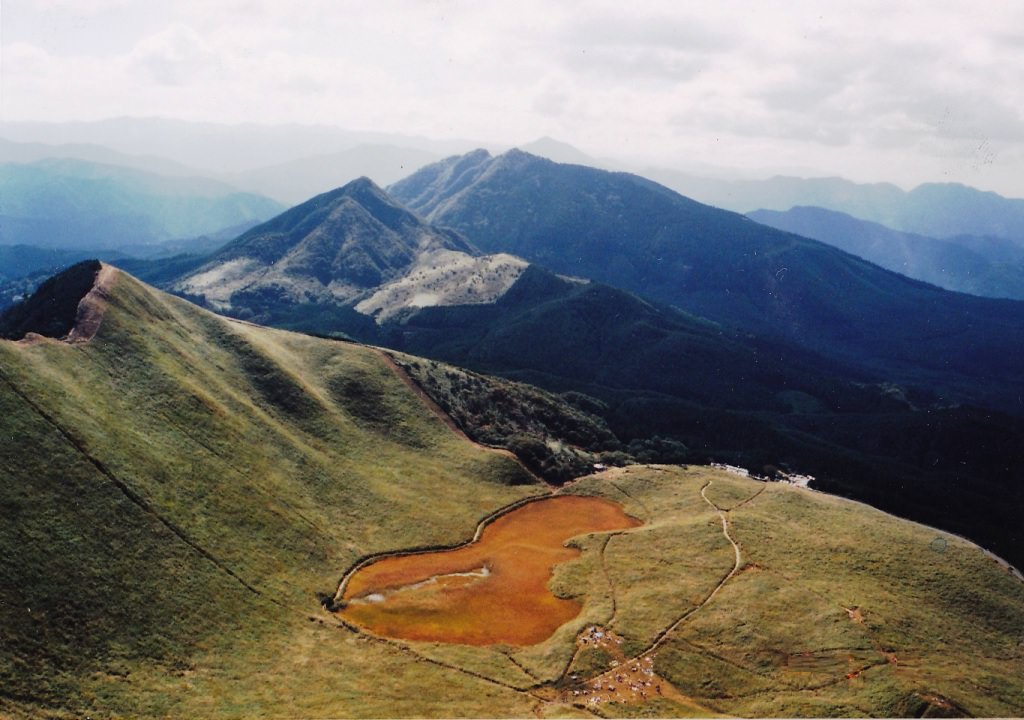
The silver-grass meadows and Okame-ike Pond at Soni Kogen, the sweeping views from Kameyama Pass, and the panorama from the summit of Mt. Kuroso are the main highlights.

Photo by Wikipedia

Your next mountain

Mt. Yamato-Katsuragi 100 Mountains of Kansai
BeginnerModerateDay tripTrail time 4h 005.9 km

A spring Kansai spectacle where azaleas described as a million blooms in one glance coat the summit plateau, with broad Osaka Plain views.

Mt. Odaigahara 100 Famous Mountains
BeginnerPlan aheadDay tripTrail time 3h 067.35 km

A deeply forested plateau receiving 4,000 mm of rain per year, mystical for the standing-dead-tree grove of Masaki-ga-hara and the Ōjagura cliff.

Mt. Horai 300 Famous Mountains
BeginnerEasyDay tripTrail time 3h 308 km

A Hira range peak with expansive Lake Biwa views, where the gondola approach leads to a ridge walk enjoyed by families.

Mt. Mikamiyama 100 Mountains of Flowers
BeginnerEasyDay tripTrail time 3h 457.2 km

Climbed it? Stamp your logbook