Mt. Kamuiekuuchikaushi (1,979 m), straddling Shin-Hidaka and Nakasatsunai in Hokkaido, is one of the 200 Famous Japanese Mountains.
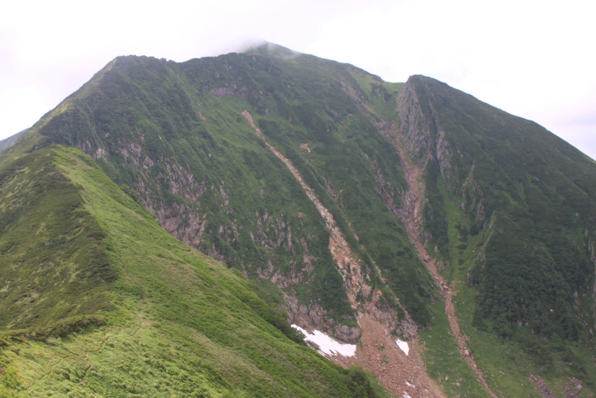
Known by the nickname “Kamueku,” it is a lone fine peak deep in the Hidaka Mountains, prized for the glacial landscape of the Hachi-no-sawa Cirque and the wide view from the summit. With continuous river-climbing, fording, bushwhacking and rocky ridges, it is one of the very hardest advanced routes among the 200 Mountains.
The trailhead is the Satsunaigawa Hut. There is no public transport, so a rental car and a multi-day plan are assumed.
The trailhead is the Satsunaigawa Hut (free, with toilet). The route runs Satsunaigawa Hut → (forest-road walk) Nana-no-sawa junction → Hachi-no-sawa junction → Hachi-no-sawa Cirque → Mt. Kamuiekuuchikaushi; the standard round trip is about 18 hours, advanced, requiring at least two nights and three days. Beyond the gate in front of the hut, vehicles are barred; it is a long forest-road walk to the Nana-no-sawa junction, and beyond that the route fords the Satsunai River repeatedly. The Hachi-no-sawa junction is the base camp (tent site).
This is one of the hardest of all the 300 Mountains, to be attempted only by parties with ample experience and equipment. Brown-bear density here is among the highest in Japan and fatal incidents have occurred, so a food container is essential and solo climbing is strictly forbidden. When the river is high it cannot be forded and you may be cut off. Notify Nakasatsunai before entering. The season is early July to late September.
How to access the trailheads
1. [Round trip] Nakasatsunai → Satsunaigawa Hut (Mt. Kamuiekuuchikaushi trailhead)
The nearest base is Nakasatsunai. From the Obihiro Station area on the JR Nemuro Main Line, pass through Nakasatsunai and follow Route 111 (Shizunai–Nakasatsunai) along the Satsunaigawa Dam; you reach the trailhead, the Satsunaigawa Hut, by rental car.
There is no route bus to the trailhead, so access is basically by rental car. Beyond the gate in front of the Satsunaigawa Hut, vehicles are barred and you continue on foot. With the long forest-road walk and the river-climbing, a day trip is impossible; a plan of at least two nights and three days, camping at points such as the Hachi-no-sawa junction, is required. You must notify Nakasatsunai in advance before entering.
– Nakasatsunai Village Office (entry notification, forest-road conditions) 0155-67-2311
Source: [Nakasatsunai Village] / [Mt. Kamuiekuuchikaushi climbing info]
Route and safety notes
Route: Satsunaigawa Hut → Nana-no-sawa junction → Hachi-no-sawa junction → Hachi-no-sawa Cirque → Mt. Kamuiekuuchikaushi. The standard round trip is about 18 hours, around 24 km, with about 1,830 m of ascent, advanced, with at least two nights and three days standard. The Hachi-no-sawa Cirque is a beautiful glacial landform, and the final stretch to the summit is a steep rocky ridge.
River-climbing and fording: beyond the Nana-no-sawa junction the route fords the Satsunai River repeatedly, demanding all-round skill in bushwhacking and rock climbing. When the river is high it cannot be crossed and you may be cut off, so watch the weather and water level closely.
Bears: brown-bear density is among the highest in Japan and fatal incidents have occurred. Carry a food container, never go alone, and move as an experienced party. Carry a portable toilet on the mountain.
Gear and season: the season is early July to late September. Carry stream gear, a tent, warm clothing, a map and compass (GPS), and submit an entry notification. Water is the stream.
In an emergency: call 110 (police) or 119 (fire/rescue).
・Nakasatsunai Village Office 0155-67-2311
Photo by Highten31 / Wikimedia Commons, CC BY-SA 3.0
Comments