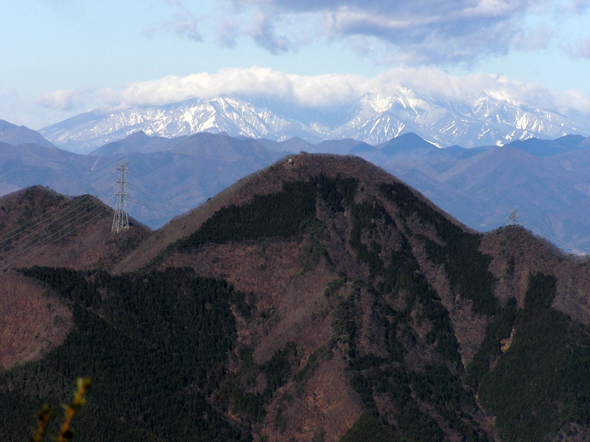
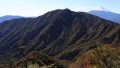
Mt. Sasagogangaharasuriyama (ささごがんがはらすりやま, 1,358m) on the Otsuki / Koshu City border, Yamanashi, is the 4th-rank peak of the Shurei Fugaku Twelve Views (paired with Mt. Takigoyama). Located directly above the Sasago Tunnel, the summit offers panoramic views of Mt. Fuji, Mt. Mitsutoge, and the Southern Alps.
Accessible by walking from JR Chuo Line Sasago Station. Intermediate ★★★・distance ~10 km・elevation gain 750 m・action time ~7 hours (day hike). Options are the Sasago Stn → Yatate-no-Sugi → Sasago Pass → summit route or the Kai-Yamato Stn → Mt. Obosan → Mt. Yonezawa → Mt. Sasagogangaharasuriyama → Sasago Stn traverse.
Access to the trailhead
- [Outbound / Return] Otsuki Stn ⇔ Sasago Stn / Kai-Yamato Stn (JR Chuo Line local)
- Sasago Pass course, Obosan traverse, suggested plans
Course time (Sasago Stn → Sasago Pass → summit round trip, day hike, Intermediate, ~7 hours)
Sasago Stn (610 m) → (0:30) → Oiwake → (1:30) → Yatate-no-Sugi → (1:30) → Sasago Pass (1,096 m) → (1:30) → Mt. Sasagogangaharasuriyama summit (1,358 m) → descent (2:00) → Sasago Stn
1. [Outbound / Return] Otsuki Stn ⇔ Sasago Stn / Kai-Yamato Stn (JR Chuo Line local)
Sasago Station (610 m, JR Chuo Line local-only) is the trailhead base; Kai-Yamato Station (660 m, JR Chuo Line local-only) is the Obosan traverse base. Otsuki → Sasago ~8 min・¥240, Otsuki → Kai-Yamato ~16 min・¥330; service approx. every 30-60 min. Private car: roadside parking near Sasago Station (few spaces), or Sasago Pass parking (few spaces, roadside free). Limited Express Kaiji / Azusa bypass Sasago / Kai-Yamato Stations.
Operating period : Year-round, JR Chuo Line local
Travel time : Otsuki Stn → Sasago ~8 min・Kai-Yamato ~16 min
Fare : Sasago ¥240, Kai-Yamato ¥330
Frequency : approx. every 30-60 min
Otsuki Stn → Sasago / Kai-Yamato Stn (JR Chuo Line local, morning hiker excerpt)
| Otsuki Stn dep | Sasago Stn arr | Kai-Yamato Stn arr |
|---|---|---|
| 5:55 (early) | 6:03 | 6:11 |
| 6:35 | 6:43 | 6:51 |
| 7:25 | 7:33 | 7:41 |
| 8:18 | 8:26 | 8:34 |
Sasago / Kai-Yamato Stn → Otsuki Stn (JR Chuo Line local, return, descent excerpt)
| Kai-Yamato Stn dep | Sasago Stn dep | Otsuki Stn arr |
|---|---|---|
| 14:47 | 14:55 | 15:03 |
| 15:47 | 15:55 | 16:03 |
| 16:47 | 16:55 | 17:03 |
Note : JR Chuo Line local timetables should always be pre-confirmed at the JR East official site. Limited Express Kaiji / Azusa bypass Sasago / Kai-Yamato Stations (transfer to local at Otsuki required). After descent, “Tenku-no-Yu” near Otsuki Station or Koshu City onsens (when doing traverse) are recommended.
Reference : JR East Chuo Line timetable | Yamanashi Hiking — Mt. Sasagogangaharasuriyama
Contact : JR Otsuki Station ☎0554-22-0029 / Otsuki Tourism Association ☎0554-22-2942
2. Sasago Pass course, Obosan traverse, suggested plans
About Mt. Sasagogangaharasuriyama
The Shurei Fugaku Twelve Views are mountains chosen by Otsuki City for their outstanding views of Mt. Fuji, with 20 summits spread across numbers 1 to 12. Mt. Sasagogangaharasuriyama, paired with Mt. Takigoyama, is counted as the 4th-rank peak and rises directly above the Sasago Tunnel of the JR Chuo Main Line. The mountain embraces the Sasago Pass of the old Koshu Kaido, and the trail is dotted with history of the old highway—including the roughly 1,000-year-old Yatate Cedar, a monument marking Emperor Meiji’s roadside rest, and the double-faced Migawari Jizo—letting you enjoy Mt. Fuji views and historic sites in a single walk.
Trail overview (2 main courses)
- Sasago Stn → Sasago Pass course (standard, Intermediate, ~7 hr): Sasago Stn → Oiwake → Shinden → Yatate-no-Sugi → Sasago tunnel → Sasago Pass → summit round trip; many historical landmarks
- Kai-Yamato Stn → Mt. Obosan traverse (Intermediate, ~7-8 hr): Kai-Yamato Stn → Mt. Obosan → Mt. Yonezawa → Mt. Sasagogangaharasuriyama → Sasago Pass → Sasago Stn; for fit hikers
Mountain huts / hot springs (2026 information)
– No huts on the trail: Day-hike basis
– Roadside parking near Sasago Station: Few spaces
– Sasago Pass parking: Few spaces, roadside free
– “Tenku-no-Yu” near Otsuki Station: Drop-in bath
– Koshu City onsens (traverse descent): Sagashio-kosen, etc.
Climbing season / flora: Year-round possible (winter with light crampons). April-May: mitsuba-tsutsuji, fresh greens; October-November: autumn colors. Winter (Dec-Feb) has snow / ice but climbing possible with light crampons.
Cautions
– Local transfer required at Otsuki: Limited Express bypasses Sasago / Kai-Yamato
– Steep climbs and many undulations: Intermediate level, for those wanting a solid hike
– Slippery after rain: Proper gear required
– Water only at trailhead stream: Carry at least 1.5 L
– Many historical landmarks: Yatate-no-Sugi, Emperor Meiji stele, etc. — allow viewing time
Emergency contacts / inquiries
- Otsuki City Office (Tourism Association): ☎0554-22-2942 / Koshu City Office: ☎0553-32-2111
- Otsuki Police (climbing notification / mountain rescue): ☎0554-22-0110
- JR Otsuki Station: ☎0554-22-0029
Suggested plans (Sasago Stn → Sasago Pass → summit round trip, day hike, recommended, standard)
- Day hike (recommended, Intermediate): Shinjuku 6:14 → Otsuki Stn 7:50 → Sasago Stn 7:58 → Oiwake 8:30 → Yatate-no-Sugi 10:00 → Sasago Pass 11:30 → summit 13:00 (Mt. Fuji panorama) → Sasago Stn 15:55 → Otsuki Stn 16:03 → return
- Obosan traverse (fit, Intermediate): Kai-Yamato Stn → Mt. Obosan → Mt. Yonezawa → Mt. Sasagogangaharasuriyama → Sasago Pass → Sasago Stn (~8 hr)
Reference : Otsuki Tourism — Mt. Sasagogangaharasuriyama | Yamanashi Hiking — Mt. Sasagogangaharasuriyama
Photo by Oda230
Comments