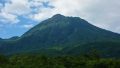
Mount Dōgamori (Dōgamori, 1,689 m) sits on the border of Saijō City and Kumakōgen Town in Ehime, and is one of Japan’s 300 Famous Mountains.
At the western end of the Ishizuchi range, its appeal lies in the wide view from its grassy summit of Mount Ishizuchi, the Seto Inland Sea and the Matsuyama plain, and the ridge running on to Ninomori and Mount Ishizuchi. From the Hoino trailhead to the summit is about 6.6 km and around 4 hours of climbing, an intermediate route.
Public transport to the trailhead has been discontinued, so you reach it by combining a taxi from Iyo-Komatsu Station on the JR Yosan Line.
The main trailhead is Hoino on the Saijō side, with parking. The main route is the Hoino trailhead → Mount Dōgamori (1,689 m) and back, about 6.6 km and around 4 hours of climbing, an intermediate route. A large microwave reflector stands on the summit, and a ridge runs on to traverse Ninomori and Mount Ishizuchi.
The best season is early summer to autumn (May–November); you can also climb from the Umegaichi trailhead (about 7.3 km) on the Kumakōgen side. Always check the forest-road conditions and arrange a taxi before you go.
*Last checked: June 7, 2026
How to access the trailheads
1. [There & Back] Iyo-Komatsu Station ⇄ Hoino trailhead (Yosan Line + taxi)
Iyo-Komatsu Station and Nyūgawa Station on the JR Yosan Line are your bases. As the local bus to the Dōgamori trailhead has been discontinued, take a taxi from the station.
① Iyo-Komatsu Station → Hoino trailhead (taxi)
The former Setouchi Shūsō Bus Hoino line was discontinued at the end of September 2023. Now you take a taxi from Iyo-Komatsu or Nyūgawa Station to the Hoino trailhead, via the mountain Prefectural Route 153.
— Komatsu Taxi 0898-72-2124.
② Yutaniguchi bus stop (for reference): the nearest bus stop is Yutaniguchi on the Niihama Express line (jointly run by Setouchi Bus and Iyotetsu Bus), but as it is more than 18 km from the Hoino trailhead, a taxi or car is realistic.
③ Note (traverse and season): the Hoino route is part of a long traverse via Dōgamori and Ninomori to Mount Ishizuchi, and going all the way to Mount Ishizuchi greatly lengthens the time. For a day hike, an out-and-back to Dōgamori is the guide.
By car: there is parking at the Hoino trailhead. Access from the Iyo-Komatsu IC on the Matsuyama Expressway via National Route 11 and Prefectural Route 153.
References: [Ishizuchi Range Official: Mount Dōgamori] / [Ishizuchi Shrine: Hoino route]
Trail Guide and Safety Notes
Route: the main route is an out-and-back from the Hoino trailhead to Mount Dōgamori (1,689 m), about 6.6 km and around 4 hours of climbing, an intermediate route. There is also a route from Umegaichi (about 7.3 km) on the Kumakōgen side, and a long, strenuous traverse from Dōgamori via Ninomori to Mount Ishizuchi.
Ridge and weather: the north side of the summit drops away in cliffs to the Kurase gorge, so take care on the ridge. The bamboo-grass slope on the south is exposed to wind and rain, and mist can make the path hard to follow. As it is a long day, start early.
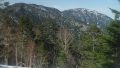
Views and nature: from the summit there is a panorama of Mount Ishizuchi, Ninomori, the Seto Inland Sea and the Matsuyama plain. The summit area is open bamboo grass with pleasant ridge walking, and the microwave reflector marks Dōgamori.
Equipment and emergencies: carry rain gear, warm clothing, a headlamp, a map/GPS, plenty of food and water. In an accident or emergency call 110 (police) or 119 (fire/ambulance).
・Saijō Police Station 0897-56-0110
Photo by As6022014 / Wikimedia Commons, Public domain
Comments