Tenen (天園), also called the Kamakura Alps, is a hiking course of about 4km that circles the outer northern part of Kamakura.
Tenen (popular name: Kamakura Alps) is a ridge hiking course connecting Kencho-ji (Hanso-bo) ~ Mt. Ohira (Kamakura City’s highest peak, 159m) ~ Zuisen-ji.
The course is well-maintained, and the appeal of combining city walking with mountain walking is a feature. Distance: about 5.5–5.8km / standard course time: about 2 hours 30 minutes – 3 hours is the guideline.
Please be sure to check the city’s official course map and the latest passage conditions in advance (Kamakura Tourism Official: Tenen Hiking Course).
Both start and goal points are within walking distance of stations, and standard one-way courses are Kita-Kamakura Station → Kencho-ji → Tenen → Zuisen-ji → Kamakura Station, or the reverse loop. When going via Kencho-ji, be careful about admission fees and visiting hours.
(Admission: adult ¥500 / elementary-middle school ¥200, hours: 8:30–16:30, Kencho-ji official).
Zuisen-ji visits are 9:00–17:00 (entry until 16:30), admission: adult ¥200 / elementary-middle school ¥100 (Zuisen-ji official).
*Timetable last checked: May 17, 2026
How to access the trailheads
- [Going] Kita-Kamakura Station → Kencho-ji (Hanso-bo Entrance)
- [Going] Kamakura Station → Daitonomiya (Zuisen-ji Entrance)
- [Return] Zuisen-ji Entrance / Daitonomiya → Kamakura Station
Hiking Course Details — Kamakura Alps / Tenen (鎌倉アルプス・天園)
Click to show current location.
Click for full-screen view.
*If the map does not appear, please click here.*
Map & Recommended Route — Kamakura Alps / Tenen (鎌倉アルプス・天園)
Model Courses
- Standard one-stroke: Kita-Kamakura Station → (15 min walk) → Kencho-ji → Hanso-bo → Shojoken Observation Deck → Mt. Ohira → near Tenen Rest Area → Zuisen-ji Entrance → (walk or bus) → Kamakura Station
- Reverse loop: Kamakura Station → (Keikyu Bus “Kama-20” bound for Daitonomiya) → Daitonomiya (Kamakura-gu) → Zuisen-ji Entrance → Tenen → Mt. Ohira → Kencho-ji → Kita-Kamakura Station
1. [Going] Kita-Kamakura Station → Kencho-ji (Hanso-bo Entrance)
Walk about 15 minutes from Kita-Kamakura Station to Kencho-ji.
After paying admission and going into the depths of Kencho-ji, you reach the trailhead.
From JR Yokosuka Line Kita-Kamakura Station, walk about 15 minutes to Kencho-ji. Pay admission at the reception (adult ¥500 / elementary-middle school ¥200) and head deep into the precincts. Going up to the ridge from Hanso-bo is the shortest route, continuing to the Shojoken Observation Deck and Mt. Ohira.
* Kencho-ji has visiting hours 8:30–16:30. Passage is not possible outside those hours. If starting early morning or evening, please consider trailheads not via temple/shrine grounds such as the Zuisen-ji Entrance or Imaizumi-dai Entrance.
Admission: adult ¥500 / elementary-middle school ¥200.
Reference: Kencho-ji official guide.
2. [Going] Kamakura Station → Daitonomiya (Zuisen-ji Entrance)
Kamakura Station East Exit → (Keikyu Bus “Kama-20” bound for Daitonomiya) → get off at Daitonomiya (Kamakura-gu), then walk 10–15 minutes to the Zuisen-ji Entrance trailhead.
Buses run roughly at 20-minute intervals during the day (schedule varies by season and day of week). Please check the latest times on Keikyu Bus official or transfer guides.
Fare: ¥240 (about 8 minutes).
Reference: Keikyu Bus Kama-20 timetable (NAVITIME).
Note: Zuisen-ji is open 9:00–17:00 (entry until 16:30), adult ¥200 / elementary-middle school ¥100. If combining temple visits with hiking, please note the times (Zuisen-ji official).
3. [Return] Zuisen-ji Entrance / Daitonomiya → Kamakura Station
On foot: From Zuisen-ji Entrance to Kamakura Station East Exit is about 35–40 minutes.
By bus: From Daitonomiya (Kamakura-gu) to Kamakura Station East Exit via Keikyu Bus Kama-20 route. Approximately every 20 minutes during the day. Check the latest schedule officially (Keikyu Bus timetable (NAVITIME)).
Fare: ¥240 (about 8 minutes)
Practical info for enjoying Tenen more
- Scenery / Seasons: Shojoken Observation Deck offers views of Sagami Bay ~ Miura Peninsula. Highlights are fresh greenery (April–May) and autumn foliage (November–December). For autumn foliage, the area around “Zuisen-ji ~ Shishimai Valley” is especially famous ().
- Supplies / Toilets: Shops and toilets along the course are limited. Use the public toilets in Kencho-ji, around Zuisen-ji, and near Daitonomiya.
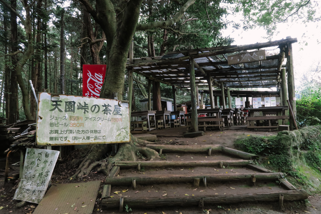
The teahouse at Tenen (popularly called the Tenen Rest Area) is open irregularly, so drinks and snacks are essential. There is recent news of reopening, but please check the latest situation on local signage and SNS (e.g.: Park city site introduction · Reopening report in hiking record). - Safety / Manners: There are slippery clay-soil steep slopes. Beware of mud and falls after rain. Beware of poisonous fungi such as Kaentake (poison fire coral) growing at tree bases, and biting midges (refer to city’s official caution: ).
- Temple/shrine visits: Both Kencho-ji and Zuisen-ji have visiting hours and admission fees. Passage outside hours is not possible.
– Kencho-ji: visits 8:30–16:30, admission adult ¥500 / elementary-middle school ¥200 (Kencho-ji official).
– Zuisen-ji: visits 9:00–17:00 (entry until 16:30), admission adult ¥200 / elementary-middle school ¥100 (Zuisen-ji official). - Bus guideline: Kamakura Station East Exit ⇄ Daitonomiya (Kama-20) is year-round operation, roughly every 20 minutes during the day. Fare: ¥240 (about 8 minutes). Always check the latest schedule (Keikyu Bus timetable).