
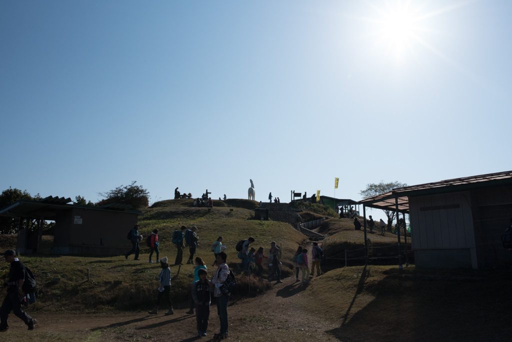
Mt. Jinba (陣馬山) is an 854.8m peak located on the border of Hachioji City in Tokyo and Midori-ku, Sagamihara City, Kanagawa Prefecture. The white horse statue standing at the summit is the symbol, and from the 360-degree observation deck, a grand panorama of Mt. Fuji, Tanzawa, and the Southern Alps unfolds. The gently sloping grassy summit offers a great sense of openness.
About 37 minutes by bus from Takao Station, about 14 minutes by bus from Fujino Station. It is also popular as a starting point for traverses to Mt. Takao and Mt. Kagenobu.
At the summit there are several teahouses where you can have light meals and rest, which is a welcome point. You can enjoy the magnificent scenery while tasting tea and the famous sansai soba. There are toilets around the teahouses, but as they may not be open in some seasons or hours, it is safe to act early.
The trails are relatively well-maintained, with many easy-to-walk courses as a feature. When using the bus bound for “Jinba-Kogen-Shita” from Takao Station, it is about 1.5–2 hours from the bus stop to the summit. When using the bus from Fujino Station and getting off at any of “Jinba Trailhead,” “Kamisawai,” or “Wada,” you can aim for the summit in similar time.
The course traversing from Mt. Jinba as a starting point to Mt. Kagenobu and Mt. Takao is recommended as the elevation difference is not too large and the scenery is varied. There are rest spots and teahouses dotted around Mt. Kagenobu and Mt. Takao too, so the enjoyment at each summit continues and the sense of achievement is also great. You can also descend partway according to your physical strength and time.
*Timetable last checked: May 16, 2026
How to access the trailheads
- [Going] Takao Station → Jinba-Kogen-Shita
- [Going] Fujino Station → Jinba Trailhead / Kamisawai / Wada
- [Return] Jinba-Kogen-Shita → Takao Station
- [Return] Wada / Kamisawai / Jinba Trailhead → Fujino Station
Hiking Course Details — Mt. Jinba (陣馬山)
Click to show current location.
Click for full-screen view.
*If the map does not appear, please click here.*
Map & Recommended Route — Mt. Jinba (陣馬山)
1. [Going] Takao Station → Jinba-Kogen-Shita
From the North Exit bus stop at JR or Keio Line Takao Station, board the Nishi Tokyo Bus [Bi-32] bound for Jinba-Kogen-Shita.
Travel time: 37 minutes | Fare: ¥680
From the bus stop to the summit of Mt. Jinba is about 1 hour 20 minutes.
Bus TimetableTakao Station → Jinba-Kogen-Shita
| Takao Station Dep. | Jinba-Kogen-Shita Arr. |
|---|---|
| 06:47 | 07:23 |
| 07:35 | 08:15 |
| 08:35 | 09:15 |
| 09:45 | 10:22 |
| 10:42 | 11:19 |
| 11:42 | 12:19 |
| 12:42 | 13:19 |
| 13:42 | 14:19 |
| 14:42 | 15:19 |
| 15:42 | 16:19 |
| 16:42 | 17:19 |
| 17:47 | 18:24 |
| 18:45 | 19:22 |
| Takao Station Dep. | Jinba-Kogen-Shita Arr. |
|---|---|
| 6:50 | 7:25 |
| 7:22 | 7:57 |
| 8:02 | 8:39 |
| 8:43 | 9:20 |
| 9:43 | 10:20 |
| 10:43 | 11:20 |
| 11:43 | 12:20 |
| 12:43 | 13:20 |
| 13:43 | 14:20 |
| 14:43 | 15:20 |
| 15:43 | 16:20 |
| 16:43 | 17:20 |
| 17:45 | 18:22 |
| 18:45 | 19:22 |
Reference: NAVITIME
2. [Going] Fujino Station → Jinba Trailhead / Kamisawai / Wada
From JR Fujino Station, board the Kanagawa Chuo Kotsu [No-08] bound for Wada and get off at any of Jinba Trailhead, Kamisawai, or Wada.
Travel time: 14 minutes (to the terminus, Wada) | Fare: ¥330 (to the terminus, Wada)
The climbing time from the bus stop to the summit is as follows.
- Jinba Trailhead: 1 hour 40 minutes
- Kamisawai: 1 hour 40 minutes
- Wada: 1 hour 10 minutes
Bus TimetableFujino Station → Jinba Trailhead / Kamisawai / Wada
| Fujino Station Dep. | Jinba Trailhead | Kamisawai | Wada Arr. |
|---|---|---|---|
| 7:25 | 7:29 | 7:31 | 7:39 |
| 8:10 | 8:14 | 8:16 | 8:24 |
| 13:52 | 13:56 | 13:58 | 14:06 |
| 14:31 | 14:35 | 14:37 | 14:45 |
| 15:25 | 15:29 | 15:31 | 15:39 |
| 16:46 | 16:50 | 16:52 | 17:00 |
| 18:06 | 18:10 | 18:12 | 18:20 |
| Fujino Station Dep. | Jinba Trailhead | Kamisawai | Wada Arr. |
|---|---|---|---|
| 8:04 | 8:08 | 8:10 | 8:18 |
| 9:06 | 9:10 | 9:12 | 9:20 |
| 9:40 | 9:44 | 9:46 | 9:54 |
| 13:12 | 13:16 | 13:18 | 13:26 |
| 14:15 | 14:19 | 14:21 | 14:29 |
| 15:25 | 15:29 | 15:31 | 15:39 |
| 16:52 | 16:56 | 16:58 | 17:06 |
| 18:06 | 18:10 | 18:12 | 18:20 |
Reference: NAVITIME
3. [Return] Jinba-Kogen-Shita → Takao Station
From Jinba-Kogen-Shita, board the Nishi Tokyo Bus [Reien-32] bound for Takao Station.
Travel time: 37 minutes | Fare: ¥680
From the summit to the bus stop is about 1 hour.
Bus TimetableJinba-Kogen-Shita → Takao Station
| Jinba-Kogen-Shita Dep. | Takao Station Arr. |
|---|---|
| 06:46 | 07:25 |
| 07:28 | 08:07 |
| 08:25 | 09:04 |
| 09:26 | 10:03 |
| 10:32 | 11:09 |
| 11:30 | 12:07 |
| 12:30 | 13:07 |
| 13:30 | 14:07 |
| 14:30 | 15:07 |
| 15:30 | 16:07 |
| 16:30 | 17:07 |
| 17:30 | 18:07 |
| 18:32 | 19:07 |
| 19:30 | 20:05 |
| Jinba-Kogen-Shita Dep. | Takao Station Arr. |
|---|---|
| 6:55 | 7:29 |
| 7:29 | 8:03 |
| 8:09 | 8:47 |
| 8:52 | 9:30 |
| 9:30 | 10:08 |
| 10:30 | 11:08 |
| 11:30 | 12:08 |
| 12:30 | 13:08 |
| 13:30 | 14:08 |
| 14:30 | 15:08 |
| 15:30 | 16:08 |
| 16:30 | 17:08 |
| 17:30 | 18:08 |
| 18:32 | 19:07 |
| 19:30 | 20:04 |
Reference: NAVITIME
4. [Return] Wada / Kamisawai / Jinba Trailhead → Fujino Station
From any of Wada, Kamisawai, or Jinba Trailhead, board the Kanagawa Chuo Kotsu [No-08] bound for Fujino Station.
Travel time: 14 minutes (from Wada) | Fare: ¥330 (from Wada)
The course time from the summit to each bus stop is as follows.
- Wada: 1 hour
- Kamisawai: 1 hour 20 minutes
- Jinba Trailhead: 1 hour 10 minutes
Bus TimetableWada / Kamisawai / Jinba Trailhead → Fujino Station
| Wada Dep. | Kamisawai | Jinba Trailhead | Fujino Station Arr. |
|---|---|---|---|
| 6:52 | 6:57 | 6:59 | 7:06 |
| 7:53 | 7:58 | 8:00 | 8:07 |
| 8:35 | 8:40 | 8:42 | 8:49 |
| 14:10 | 14:15 | 14:17 | 14:24 |
| 14:51 | 14:56 | 14:58 | 15:05 |
| 15:47 | 15:52 | 15:54 | 16:01 |
| 17:05 | 17:10 | 17:12 | 17:19 |
| 18:22 | 18:27 | 18:29 | 18:36 |
| Wada Dep. | Kamisawai | Jinba Trailhead | Fujino Station Arr. |
|---|---|---|---|
| 8:24 | 8:29 | 8:31 | 8:38 |
| 9:23 | 9:28 | 9:30 | 9:37 |
| 10:11 | 10:16 | 10:18 | 10:25 |
| 13:42 | 13:47 | 13:49 | 13:56 |
| 14:32 | 14:37 | 14:39 | 14:46 |
| 15:42 | 15:47 | 15:49 | 15:56 |
| 17:09 | 17:14 | 17:16 | 17:23 |
| 18:24 | 18:29 | 18:31 | 18:38 |
Reference: NAVITIME
Comments