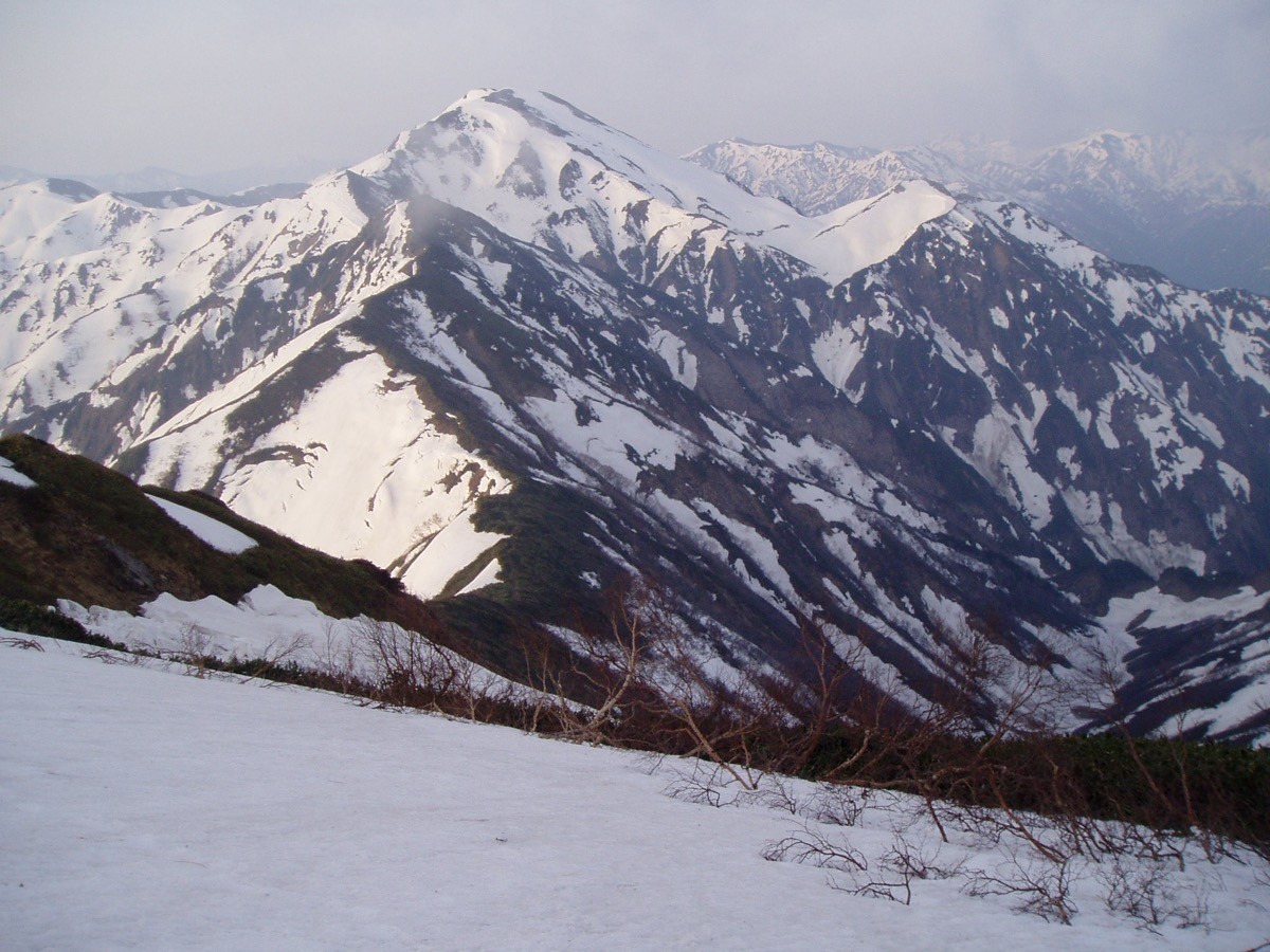
Mt. Nakano (中ノ岳, 2,085 m), straddling Minamiuonuma and Uonuma in Niigata, is one of the 200 Famous Japanese Mountains.
With Mt. Hakkai and Mt. Echigo-Koma it forms the Echigo Three Mountains, and as their highest peak it is prized for its gentle half-moon summit and the snow patches that linger even in midsummer in this heavy-snow region. The route from Jujikyo is an advanced climb of continuous steep ascent with about 1,600 m of elevation gain, with several chain-assisted rock sections.
The trailhead is the Jujikyo trailhead center. Convenient services to the trailhead are few, so a taxi or rental car from Muikamachi Station is assumed.
The trailhead is the Jujikyo trailhead center (parking and toilet). The route runs Jujikyo → Senbon-matsubara (2nd station) → 5th station → Kotenjo → Ike-no-dan → Mt. Nakano; it is about 6 hours from the trailhead to the summit, advanced, with around 1,600 m of ascent. It is a tough long haul with scattered chain-assisted rock sections, and although a day trip is possible, the route is long, so building in an overnight or a stay at the summit emergency hut is reassuring. At the summit there is an unstaffed Nakano-dake emergency hut holding 40–50 people.
As snow patches linger late in this heavy-snow region, watch for slips and unclear routes in the residual-snow season, and be ready for black bears. The season is early July to mid-October.
How to access the trailheads
1. [Round trip] Muikamachi Station → Jujikyo trailhead center (Mt. Nakano trailhead)
The nearest base is Muikamachi Station (JR Joetsu Line / Hokuhoku Line). You can take a Minami-Echigo Kanko Bus (bound for Nonaka) from Muikamachi to Nonaka, but from Nonaka it is about a 2-hour walk to the Jujikyo trailhead center and the buses are infrequent, so a direct taxi from Muikamachi to Jujikyo (about 30 minutes, around ¥7,500) is the practical choice. By rental car it is about 40 minutes from the Muikamachi interchange.
As the route is long and an early start is best, build in an overnight stay and check the latest bus times and forest-road conditions in advance.
– Minamiuonuma City Office, Commerce & Tourism Division (climbing, road info) 025-773-6665
Source: [Minamiuonuma Tourism Association, Mt. Nakano]
Route and safety notes
Route: Jujikyo trailhead center → Senbon-matsubara → 5th station → Kotenjo → Ike-no-dan → Mt. Nakano. It is about 6 hours from the trailhead to the summit, advanced, with about 1,600 m of ascent. At Ike-no-dan you reach the ridge toward Mt. Echigo-Koma, and from the summit you overlook the Echigo Three Mountains and the peaks of Uonuma.
Chains and steep climbing: the steep ascent begins early and there are several chain-assisted rock sections. Watch especially for falls and slips on the descent and pace yourself sensibly.
Snow and season: in this heavy-snow region snow patches linger even in midsummer. In the residual-snow season routes can become unclear and light crampons may be needed. The season is early July to mid-October.
Bears and gear: this is black-bear country, so carry a bear bell and avoid going alone. Water sources are limited, so carry plenty, and bring a sleeping bag and mat for a stay at the summit hut.
In an emergency: call 110 (police) or 119 (fire/rescue).
・Minamiuonuma City Office 025-773-6665
Photo by Oyama no taisho / Wikimedia Commons, CC BY-SA 4.0
Comments