
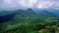
Mt. Kamuro (神室山, 1,365 m), on the border of Yuzawa (Akita) and Kaneyama (Yamagata), is one of the 200 Famous Japanese Mountains.
The main peak of the Kamuro range, with its sharp rocky ridges and steeply dropping crests, it is called the “Alps of Michinoku” and is a fine peak rich in alpine plants. Crossing streams and tackling steep climbs to reach the ridge, it is a varied intermediate-to-advanced mountain.
There is no local bus to the popular trailhead, so a taxi from the nearest station is the norm. The nearest station is Yuzawa on the JR Ou Main Line. You reach the Nishinomata course trailhead at Yakunai by taxi from Yuzawa Station.
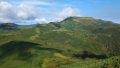
The trailhead is the Nishinomata course trailhead at Yakunai (Yuzawa, Akita). The standard route is a loop: Nishinomata course trailhead → Nishinomata stream → Fudo-myoo → Otanokami → Mt. Kamuro → Mae-Kamuro → Panorama course, with a standard time of about 7 hours, intermediate-to-advanced level. After fording the stream and climbing the steep “Munetsuki” slope, the flower fields and the wide view from the sharp ridge open up.
Near the summit there is the Mt. Kamuro emergency hut, a rest point and refuge. The season runs from early summer once the snow has gone to autumn foliage (roughly June to October). In the snow-melt season and after heavy rain, fording the Nishinomata stream becomes difficult, so take care. Always check the latest trail and forest-road conditions in advance.
How to access the trailheads
1. [Round trip] Yuzawa Station → Yakunai (Nishinomata course trailhead)
The base is Yuzawa Station on the JR Ou Main Line. There is no local bus to the Yakunai trailhead, so a taxi is the standard option.
To the Nishinomata course trailhead is about 1 hour by taxi from Yuzawa Station (about 27 km along the Yakunai River). No taxis wait at the trailhead and mobile phone reception is poor, so booking both the outbound and return rides in advance is essential. As the loop takes about 7 hours, allow margin in the descent time you give for the pickup.
– Yuzawa Taxi 0183-73-2151
Public transport from the Yamagata side: You can also reach the Ariya trailhead on the Yamagata side from JR Shinjo Station by combining a local bus (Shinjo–Kaneyama) and the Kaneyama town bus (Ariya line), but services are few and vary by season and day, so check the times in advance with Kaneyama Town (town bus). If you drive, there is parking for about 10 cars at Yakunai.
Source: [Shinjo City, Mt. Kamuro] / [Visit Mogami, Mt. Kamuro]
Route and safety notes
Route: Nishinomata course trailhead → Nishinomata stream (ford) → Fudo-myoo → Otanokami → Mt. Kamuro (1,365 m) → Mae-Kamuro → Panorama course → trailhead, a loop. The standard time is about 7 hours, intermediate-to-advanced level. There is the Mt. Kamuro emergency hut near the summit. The flower-field ridge has many sharp drop-offs, so take care when passing others and against falls.
Fording note: The Nishinomata course fords the Nishinomata stream. In the snow-melt season and after heavy rain, high water makes the crossing difficult, so check the weather not only for the day but for the preceding several days, and do not force it.
Forest road and access: The road along the Yakunai River to the trailhead runs deep into the mountains and can be closed after heavy rain. Check the latest road and trail conditions in advance.
Gear and season: The season runs June to October. Carry water, food, rain gear, warm clothing, a headlamp, and a map/GPS.
Emergencies: In case of accident or distress, call 110 (police) or 119 (fire/rescue).
・Yuzawa City Hall 0183-73-2111
Photo by らんで / Wikimedia Commons, CC BY-SA 3.0
Comments