
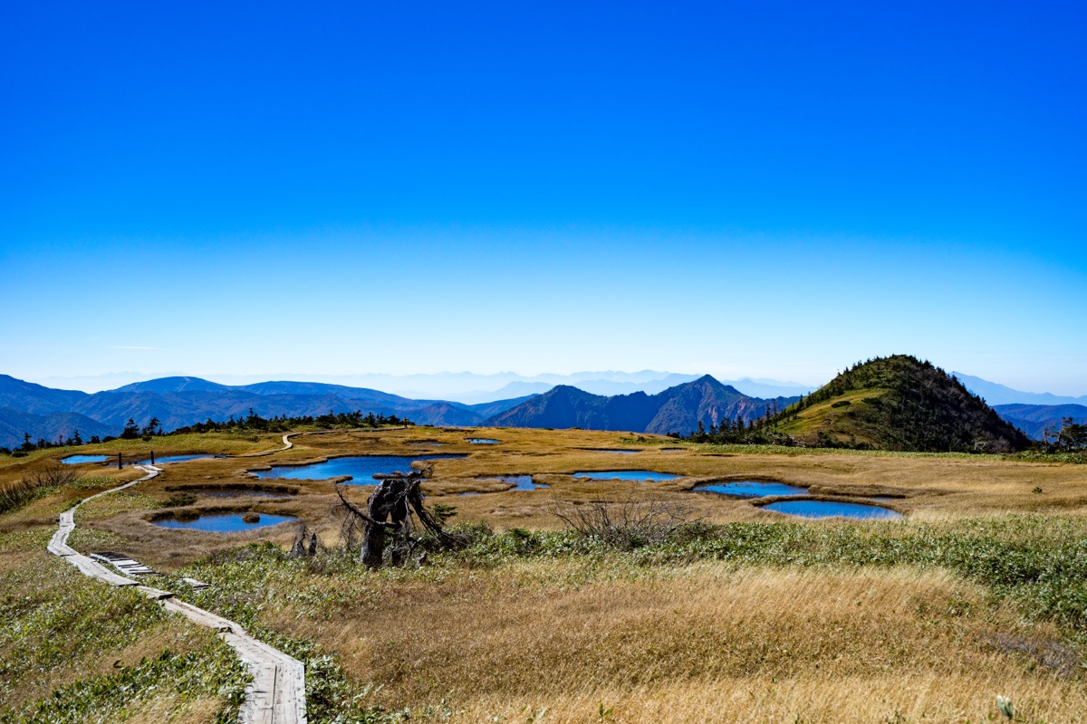
Mt. Naeba (苗場山, 2,145 m) straddles Yuzawa Town and Tsunan Town in Niigata Prefecture and Sakae Village in Nagano Prefecture, within Joshinetsu-kogen National Park. Famous for the largest high-altitude wetland in Japan on its summit (~4 km², ~800 tarns), it is a 100 Famous Mountain of Japan (Kyūya Fukada’s selection).
The summit is the “Sky Garden“, a vast wetland with skunk cabbage in June, cottongrass and yellow daylily in July, and grass autumn colours in September. The most popular Haraigawa course (Yuzawa side) via Wada-goya hut (5th station) is intermediate ★★★ / ~7 h. The Koakazawa course (Akiyama-gō, Nagano side) offers a shorter approach.
How to access the trailheads
- [Outbound] Tokyo / Osaka → Echigo-Yuzawa Station (JR Joetsu Shinkansen)
- [Round trip] Echigo-Yuzawa Station ⇔ Haraigawa trailhead (taxi / car)
- Wada-goya, Koakazawa course, suggested plans
Standard times (Haraigawa course out-and-back, intermediate, ~7 hours)
Haraigawa trailhead (1,200 m) → (30 min) → Wada-goya (5th station, water) → (2 hr) → Kagura-ga-mine → (1 hr) → Raisei-mizu (8th station) → (1 hr) → Mt. Naeba summit (2,145 m, summit wetland) → (2 hr 30 min) → Haraigawa trailhead
1. [Outbound] Tokyo / Osaka → Echigo-Yuzawa Station (JR Joetsu Shinkansen)
The base for Mt. Naeba is Echigo-Yuzawa Station. From Tokyo Station, the JR Joetsu Shinkansen Toki / Tanigawa takes about 1 h 15–30 min for ¥6,790 (reserved). From Osaka, about 4 hours via Tokyo. From abroad / Kansai, fly to Niigata Airport, then airport limo bus to Niigata Station and Shinkansen to Echigo-Yuzawa.
JR and airport access guide :
Tokyo Station → Echigo-Yuzawa Station : JR Joetsu Shinkansen Toki about 1 h 15 min, ¥6,790 (reserved)
Tokyo Station → Echigo-Yuzawa Station : JR Joetsu Shinkansen Tanigawa about 1 h 30 min, ¥6,790
Osaka Station → Echigo-Yuzawa Station : JR via Tokyo about 4 h, ~¥17,000
Niigata Airport → Echigo-Yuzawa Station : via Niigata Station, ~2 h 30 min
Reference : JR East | Echigo-Yuzawa Tourism Navi
Inquiries : JR Echigo-Yuzawa Station ☎025-784-2031
2. [Round trip] Echigo-Yuzawa Station ⇔ Haraigawa trailhead (taxi / car)
For the Haraigawa course trailhead Haraigawa (1,200 m), there is no route bus — taxi or car only. By taxi from Echigo-Yuzawa Station east exit, ~25 min / ~¥4,000 one way (cheaper shared). By car, ~18 km / ~30 min from Yuzawa IC on the Kan’etsu Expressway; the Haraigawa parking lot (~150 spaces, free). From the parking to the trailhead is ~30 min on foot on a forest road.
Access guide :
Echigo-Yuzawa Station east → Haraigawa trailhead : taxi ~25 min, ~¥4,000 one way
Yuzawa IC → Haraigawa trailhead : ~18 km / ~30 min by car, parking ~150 spaces
Haraigawa parking → trailhead : ~30 min on foot (forest road)
※ Alternative: Echigo-Yuzawa east → Minami Echigo Kanko Bus → Kagura Mitsumata (~20 min, ¥400) → Tashiro Station (~15 min, ¥570) → Ropeway (seasonal)
Note : There is no route bus to the Haraigawa trailhead — taxi reservation is recommended (Echigo-Yuzawa Station taxi stand for same-day, but book ahead for the descent pickup). The Kagura ski-resort route (direct to Wada-goya) is limited outside the winter ski season; in summer, Haraigawa trailhead is the standard. After descending, bathe at Echigo-Yuzawa Onsen “Edo no Yado Fukumoto” / “Yuzawa Grand Hotel”, or in the station’s “Ponshu-kan Yu-kemuri-dokoro” (¥800, famous for sake bath).
Reference : Wada-goya to Haraigawa autumn climb | Wada-goya official
Inquiries : Yuzawa Taxi ☎025-784-2025 / Echigo-Yuzawa Onsen Tourism Association ☎025-785-5505
3. Wada-goya, Koakazawa course, suggested plans
About Mt. Naeba
A free-standing peak (2,145 m) straddling Yuzawa and Tsunan in Niigata’s Minami-Uonuma and Naka-Uonuma districts and Sakae Village in Nagano’s Shimo-Minochi district, within Joshinetsu-kogen National Park. The summit holds Japan’s largest high-altitude wetland (~4 km², ~800 tarns), the “Sky Garden“. The name “Naeba” (rice-seedling field) comes from the tarns resembling rice paddies. The infrastructure includes Kagura Ski Resort (winter) and the Naebasan Nature Experience Centre (summit hut). Selected by Fukada as one of his 100 Famous Mountains.
Trail summary (2 main courses)
- Haraigawa course (Yuzawa side) (intermediate, ~7 h, most popular): Haraigawa → Wada-goya → Kagura-ga-mine → summit out-and-back, via Kagura Ski Resort
- Koakazawa course (Sakae Village, Akiyama-gō side) (intermediate, ~6 h): from Akiyama-gō, steep but short approach
Huts and hot springs
– Wada-goya (5th station, Haraigawa course, ☎025-789-3055): overnight Saturdays / pre-holidays only; famous kenchin udon; the climbing base, run by Prince Hotels
– Naebasan Nature Experience Centre (summit emergency hut, free, bring bedding): in the centre of the summit wetland, capacity ~100, toilet & water (tarn water — boil)
– Echigo-Yuzawa Onsen: many around the station; in the station “Ponshu-kan Yu-kemuri-dokoro” (¥800, sake bath)
– Akayu Onsen “Yamaguchi-kan”: south side of the summit, a secluded onsen
Climbing season / flowers: June – October. June: skunk cabbage; July: cottongrass and yellow daylily; August: Tateyama gentian and Hakusan-kozakura; September: grass autumn colours (the whole summit wetland turns golden). Residual snow lingers near Kagura-ga-mine until early June.
Cautions
– Stay strictly on boardwalks in the summit wetland: vegetation protection
– Limited water sources: only near Wada-goya and in the summit wetland — carry at least 2 L
– No bus to Haraigawa trailhead: taxi reservation recommended
– Bear sightings: carry bells
Emergency contacts and inquiries
- Yuzawa Town Tourism Section (Haraigawa side): ☎025-784-3457 / Echigo-Yuzawa Onsen Tourism Association: ☎025-785-5505
- Sakae Village Hall (Koakazawa / Akiyama-gō side): ☎0269-87-3111
- Yuzawa Police Station (climbing plan, mountain rescue): ☎025-784-0110
- Wada-goya (lodging, inquiries): ☎025-789-3055 / Yuzawa Taxi: ☎025-784-2025
Suggested plans
- Day hike, Haraigawa course (intermediate / fit): Tokyo 6:32 → Echigo-Yuzawa 7:46 → taxi → Haraigawa trailhead 8:30 → Wada-goya 9:00 → summit 12:30 → descend → Haraigawa 16:00 → taxi → Echigo-Yuzawa 16:30 → Ponshu-kan bath → return
- One night, summit hut overnight (recommended): Day 1 Echigo-Yuzawa → Haraigawa → summit wetland → Naebasan Hut overnight (bring bedding; sunset and stars). Day 2 early wetland walk → descend → Echigo-Yuzawa onsen. The September grass-colours season is spectacular from the summit hut
Reference : Echigo-Yuzawa Navi Wada-goya | Mt. Naeba Haraigawa course guide
Photo by jdolan78 (Flickr)
Comments