
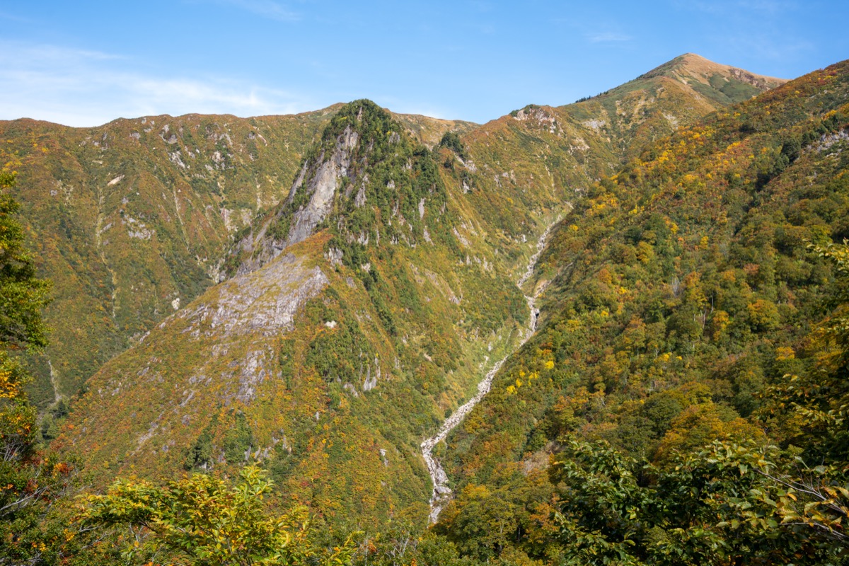
Mt. Makihata (1,967m) straddles Minamiuonuma City (Niigata Prefecture) and Minakami Town (Gunma Prefecture) at the northern end of the Tanigawa Range and is counted among the 100 Famous Mountains of Japan. The summit ridge is a vast alpine wetland strewn with countless tarns (chitō) — Fukada Kyūya called it “a magnificent mountain”. Nikkō-kisuge (day-lilies), chinguruma, and Hakusan-kozakura (primrose) bloom in summer, and the rust-red kusa-momiji (autumn grass color) in late September to early October is breathtaking.
The Ido-One ridge route from the Shimizu trailhead (Niigata side) is the only generally maintained hiking path. The sub-route via Nukubi-zawa has been effectively closed since the 2011 Niigata-Fukushima torrential rains. Sakurazaka Parking Lot (elev. 730 m, ~100 cars, ¥500/day) — about 25 min by taxi from JR Joetsu Line Muikamachi Station — is the realistic access point. On April 1, 2026, the former local bus line (Sawaguchi-Shimizu — Muikamachi) was abolished and replaced by the city’s new AI-on-demand transit “MOSS”, which does not operate on weekends or holidays. Hikers therefore depend mainly on taxi or private car.
Access to Trailhead
- [Outbound] Tokyo / Osaka → Muikamachi Station (Joetsu Shinkansen + JR Joetsu Line)
- [Outbound] Muikamachi Station → Sakurazaka Parking (Trailhead) — 3 Options
- MOSS “Ueda Fixed-Route” Timetable (effective April 1, 2026)
Travel times from major hubs
Tokyo Sta. → Echigo-Yuzawa Sta.: Joetsu Shinkansen “Toki” approx. 80 min (¥6,790) | Omiya Sta. → Echigo-Yuzawa Sta.: approx. 65 min | Echigo-Yuzawa → Muikamachi: JR Joetsu Line local 20 min (¥330) | Muikamachi Station → Sakurazaka Parking: taxi approx. 25 min (¥6,000–7,000) | Shin-Osaka → Echigo-Yuzawa via Tokyo: Tokaido + Joetsu Shinkansen approx. 4 h 20 min
1. [Outbound] Tokyo / Osaka → Muikamachi Station
From Tokyo, take the Joetsu Shinkansen “Toki” to Echigo-Yuzawa Station (approx. 80 min), then transfer to the JR Joetsu Line local train and travel another 20 min to Muikamachi Station. Some “Toki” and “Tanigawa” services have well-timed transfers, but the local train runs roughly once per hour, so check the connection in advance.
Service period: Year-round
Travel time: Echigo-Yuzawa → Muikamachi local train 20–22 min
Fare: Echigo-Yuzawa → Muikamachi local one-way ¥330 (as of 2026)
Frequency: Roughly 1 train per hour (gaps of up to 2 h in early morning / late evening)
Reference: JR East Muikamachi Station | JR East Echigo-Yuzawa Station
JR Joetsu Line TimetableEchigo-Yuzawa → Muikamachi (toward Nagaoka, local trains)
| Dep. Echigo-Yuzawa | Arr. Muikamachi |
|---|---|
| 06:34 | 06:54 |
| 07:09 | 07:30 |
| 08:02 | 08:24 |
| 09:03 | 09:24 |
| 10:30 | 10:52 |
| 12:14 | 12:34 |
| 13:14 | 13:36 |
| 14:16 | 14:37 |
| 15:12 | 15:33 |
| 16:10 | 16:31 |
| 17:18 | 17:40 |
| 18:51 | 19:13 |
| 20:33 | 20:53 |
| 21:34 | 21:55 |
Reference: [NAVITIME Echigo-Yuzawa → Muikamachi]
2. [Outbound] Muikamachi Station → Sakurazaka Parking (Trailhead) — 3 Options
After the April 2026 bus-line abolition, there is no longer any scheduled bus from Muikamachi Station to Shimizu / Sakurazaka. Hikers choose between three options.
(A) Taxi (most reliable, works weekdays and weekends)
About 25 min, ¥6,000–7,000 from Muikamachi Station to Sakurazaka Parking (¥7,000+ at night / early-morning surcharges). Major operators: Ginrei Taxi (025-772-2440), Masugata Taxi (025-772-4121), and Muikamachi Taxi (025-772-2550). Reserve the night before for pre-dawn (04:30–05:00) departures.
(B) MOSS (AI on-demand transit) — Weekdays only, 9:00–17:30
The “MOSS” on-demand service launched April 1, 2026. Operating days: Mon–Fri only (closed Sat/Sun/holidays and Dec 31 – Jan 3); operating hours 9:00–17:30. Reserve via the smartphone app (iOS/Android) or by phone (025-775-7778, call centre 8:30–17:00), from 1 week to 30 min ahead. Fare: adult ¥300 (¥100 discount for first 3 months when booking via app). Stops “Shimizu” or “Shimizu-iriguchi” are closest to the trailhead.
Note: weekend hikers and those wanting an early start should rely on (A) taxi instead — MOSS does not run on weekends.
(C) Private car
Approx. 25 min from Shiozawa-Ishiuchi IC (Kan-Etsu Expressway) or 20 min from Muikamachi IC. Take Route 291 toward Shimizu; just before Shimizu village, turn left and drive ~2 km to Sakurazaka Parking. Sakurazaka Parking: ¥500/day, ~100 spaces, restroom available, paved. May fill up in peak fall foliage and Golden Week. Winter access (December – early April) closed.
Reference: Minamiuonuma City — MOSS Official
3. MOSS “Ueda Fixed-Route” Timetable (effective April 1, 2026)
MOSS also offers a “fixed-route” service (no reservation needed) that inherits the morning and evening runs of the former Sawaguchi-Shimizu — Muikamachi bus line. Operates on weekdays only (Mon–Fri) and Dec 29–30 (closed Sat/Sun/holidays and Dec 31 – Jan 3). Operator: Ginrei Taxi Co., Ltd. (025-772-2440).
For hikers, the morning Shimizu → Muikamachi run is potentially useful on the descent day. The evening Muikamachi → Sawaguchi run terminates at Sawaguchi — it does NOT continue to Shimizu.
MOSS Ueda Fixed-Route TimetableUeda (Shimizu) → Muikamachi (Morning, weekdays only)
| Departure stop | Dep. time | Arr. Muikamachi Station-mae |
|---|---|---|
| Shimizu (Bus 1) | 6:43 | 7:15 |
| Sawaguchi (Bus 2) | 7:40 | 8:05 |
MOSS Ueda Fixed-Route TimetableMuikamachi → Ueda (Evening, weekdays only — terminates at Sawaguchi)
| Dep. Muikamachi Station-mae | Arr. Sawaguchi |
|---|---|
| 18:10 | 18:35 |
Reference: [Minamiuonuma City — Community Bus Timetables] | [MOSS Official Page]
Routes & Emergency Hut Info
Main Route
– Ido-One ridge route (intermediate, ~7h round trip / 12km): Sakurazaka parking (730m) → 5th station → 7th station → Mae-Makihata (false summit) → Mt. Makihata summit (1,967m)
Emergency Hut
– Makihata Emergency Hut (between Mae-Makihata and summit): unstaffed year-round, no bedding, emergency use, capacity ~30
– Sakurazaka Parking: 100 spaces, ¥500/day, toilets available
Regulations
– Hiking season: late May – late October
– Forest road closed: late November – late April
– Yoneko-sawa route eroded since 2011 floods, Nukibi-sawa requires sawa-climbing — general hikers use only Ido-One ridge
– Autumn foliage: early-mid October
Emergency Contacts
– Minamiuonuma City Industry & Tourism: 025-773-6665
– Minamiuonuma Police (mountain rescue): 025-783-0110
Reference: Minamiuonuma City Tourism
Photo by Raita Futo
Comments