Mt. Nogohaku (能郷白山, 1,617 m), straddling Motosu City and Ibigawa Town in Gifu Prefecture and Ono City in Fukui Prefecture, is one of the 200 Famous Japanese Mountains.
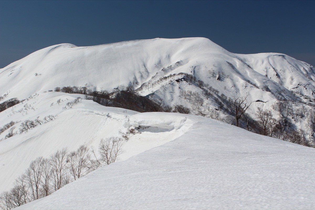
It is the highest peak on the Gifu–Fukui border in the Ryōhaku Mountains, with a first-order triangulation point and a small Hakusan-Gongen shrine at its summit, and a panorama taking in Mt. Haku and Mt. Ontake. The Nogodani route, the one reachable by public transport, is a fit-hiker course of about 9–10 hours round trip including a forest-road walk.
The nearest station is Tarumi, the terminus of the Tarumi Railway. From there you reach the Nogodani trailhead by taxi.
The trailhead is the Nogodani parking area (a forest-road gate), from where you follow the forest road onto the mountain trail. The route runs Nogodani → old-trail junction → Maeyama → Mt. Nogohaku summit and back, about 15 km of walking, about 1,450 m of cumulative elevation gain, about 9–10 hours round trip for fit hikers. Old-growth beech forest and steep climbs continue, and the view opens once you reach the ridge.
The other Nukumitōge route (about 4 hours round trip) is shorter, but National Route 157 is closed, so it is currently inaccessible and has no public transport. The season is May to October. The area is home to Asian black bears, so take precautions such as a bear bell. There is little in the way of shops or water on the mountain, so prepare ample water and food.
How to access the trailheads
1. [Outbound & Return] Tarumi Station → Nogodani trailhead (taxi)
Get off at Tarumi Station, the terminus of the Tarumi Railway (about 1 hour from Ōgaki Station), and reach the Nogodani trailhead by Neo Taxi in about 20 minutes (about 8 km).
There is no regular bus directly to Nogodani, so a taxi from Tarumi Station is the realistic option. Since the Nogodani route takes about 9–10 hours round trip, it is safest to reach Tarumi Station on an early train for an early start, or to stay overnight. Book a return pick-up to match your descent time.
– Neo Taxi 0581-38-2013 (in front of Tarumi Station)
The Nukumitōge route is meant for cars, but it cannot be used while National Route 157 remains closed. Check the latest road conditions.
Source: [Gifu Travel Guide, Mt. Nogohaku] / [Tarumi Railway]
Route and safety notes
Route: Nogodani (parking) → forest road → old-trail junction → Maeyama → Mt. Nogohaku summit. About 9–10 hours of walking round trip with about 1,450 m of cumulative elevation gain, for fit hikers — a long day of steep climbs and beech forest.
Coping with the long day: the forest-road walk is long, so beware of running out of time when daylight is short. Always carry a headlamp and map, and be ready to turn back early rather than push on.
Bears: the area is home to Asian black bears. Take precautions such as a bear bell and avoid going alone.
Gear and season: the season is May to October. Water is scarce, so carry plenty, along with food and rain gear, and submit a climbing plan.
In an emergency: call 110 (police) or 119 (fire/rescue).
・Neo Taxi (pick-up / descent contact) 0581-38-2013
Photo by Alpsdake / Wikimedia Commons, CC BY-SA 3.0
Comments