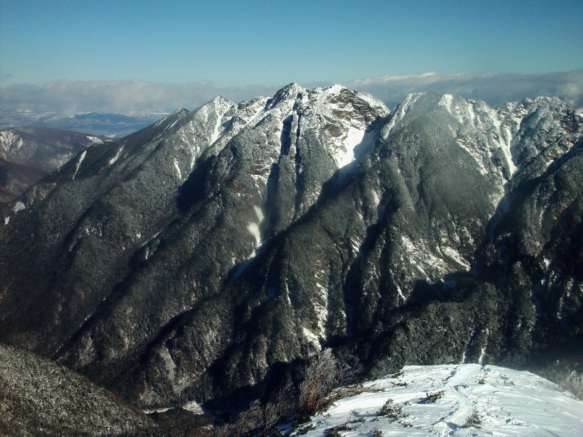
Mt. Nokogiri (鋸岳, 2,685 m), straddling Ina in Nagano and Hokuto in Yamanashi, is one of the 200 Famous Japanese Mountains.
True to its name (“saw peak”), it is a craggy summit at the northern end of the Southern Alps where saw-tooth rock ridges fall away sharply, and the Kakubeizawa route up to the First High Point (2,685 m) is known as one of the Southern Alps’ hardest, with rock pitches and demanding route-finding. There is no staffed mountain hut, and you reach the ridge by working up the Todai River, so it is a peak for seasoned climbers with solid rock-ridge experience and map-reading skill. There is also an advanced traverse from Mt. Kaikoma over the rocky Great Gap, Small Gap and Shika-mado.
The trailhead is Todai-gawara. There is no direct bus to the trailhead, so the premise is to take a bus from Ina-shi Station to Senryuso (Todaiguchi) and then walk up the Todai River toward Kakubeizawa.
The trailhead is Todai-gawara (about 1,005 m; free parking available). The usual approach works up the bed of the Todai River, climbs the steep Kakubeizawa gully from its mouth to the Kakubeizawa col (about 2,550 m), and aims for the First High Point. It is one of the Southern Alps’ hardest routes, with continuous rock and loose scree, many unclear sections, and a topographic map, GPS (compass) and solid rock-ridge experience are essential on this advanced route. A two-day trip using the Oiwa-shita rock shelter on the way (room for 3–4 tents, with water) is safest, and even a strong-legged day trip is only for experts in the right conditions.
As there is no staffed hut, carry all food, water and gear yourself, and submit a climbing plan. The season is late June to October, after the lingering snow clears (snow season requires still more advanced snow-ridge skills).
How to access the trailhead
1. [Round trip] Ina-shi Station → Senryuso (Todaiguchi) → Todai-gawara (Mt. Nokogiri trailhead)
The nearest base is Ina-shi Station (JR Iida Line). There is no direct bus to the Todai-gawara trailhead; the basic plan is to take the Ina Bus (Takato–Senryuso line) from Ina-shi Station to Senryuso (Todaiguchi), then walk up the bed of the Todai River to the mouth of Kakubeizawa. By car, use the free parking at Todai-gawara (about 1,005 m), reached from the Ina IC on the Chuo Expressway via Route 87 and Route 152 to Todaiguchi. In the snow season or after heavy snow-clearing you may only be able to drive as far as the area before the power station, so check the latest road and bus operation in advance.
– Ina Bus (Takato–Senryuso line) 0265-72-5111 / Senryuso 0265-98-2821
Source: [Ina City – Southern Alps info (Todai / Mt. Nokogiri)]
Route and safety notes
Route: Todai-gawara → mouth of Kakubeizawa → Kakubeizawa col → First High Point (Mt. Nokogiri). It is one of the Southern Alps’ hardest routes, advanced, with rock, scree and demanding route-finding. The traverse from Mt. Kaikoma over the Great Gap, Small Gap and Shika-mado is harder still.
Hard route and gear: the trodden path is unclear in many places, so a topographic map and GPS (compass) and solid rock-ridge experience are essential. Wear a helmet; a rope is needed in places.
Huts and water: there is no staffed hut; the Oiwa-shita rock shelter on the way (room for 3–4 tents, with water) is the base. Carry all food, water and gear yourself.
Season: the season is late June to October, after the lingering snow clears. The snow season requires still more advanced snow-ridge skills, and beginners should not go unaccompanied. Submit a climbing plan and carry warm and rain gear and a map and compass (GPS).
In an emergency: in a mishap or accident, call 110 (police) or 119 (fire/rescue).
・Ina City Office 0265-78-4111
Photo by Alpsdake / Wikimedia Commons, CC0
Comments