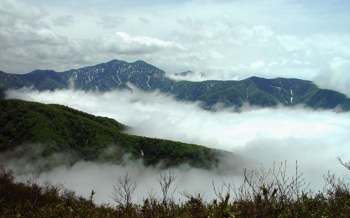
Mt. Kyōgatake (経ヶ岳, 2,296 m), straddling Ina City and Minamiminowa Village in Nagano Prefecture, is one of the 200 Famous Japanese Mountains.
It stands at the northern end of the Kiso Mountains (Central Alps), and stone Buddhas and stone pagodas are enshrined on its summit. It has long been a site of mountain worship, tied to the sutra-mound legend of the priest Jikaku Daishi. The route from Habiro (Chūsenji Temple) is a long forest-belt course of about 8 hours round trip, making for a full day suited to fit hikers.
The nearest station is Ina-shi on the JR Iida Line. From the Ina Bus Terminal in front of the station, you reach the Habiro trailhead by the Nishi-Minowa Line bus.
The trailhead is behind Chūsenji Temple (Habiro Kannon) in Habiro (about 900 m elevation). The route runs Chūsenji → 4th station → Ōizumisho (water source) → 7th station → 8th station → Kurosawayama junction → Kyōgatake summit (2,296 m) and back, a fit-hiker course of about 1,400 m elevation gain and about 8 hours of walking round trip. The views open up between the 7th and 9th stations, but most of the climb is quiet forest-belt walking.
The season is May to November. The area is home to Asian black bears, so be sure to take precautions such as a bear bell. There are no shops or huts on the mountain, so prepare water, food and rain gear.
How to access the trailheads
- [Outbound] Ina-shi Station (Ina Bus Terminal) → Habiro (Chūsenji trailhead)
- [Return] Habiro (Chūsenji trailhead) → Ina-shi Station (Ina Bus Terminal)
1. [Outbound] Ina-shi Station (Ina Bus Terminal) → Habiro (Chūsenji trailhead)
Get off at Ina-shi Station on the JR Iida Line, walk about 2 minutes to the Ina Bus Terminal, and take the Ina Bus Nishi-Minowa Line (toward Habiro / Yochi) to the Habiro stop (about 27 minutes, fare capped at ¥310, daily service). The Habiro stop is right in front of Chūsenji Temple (Habiro Kannon), and the trailhead is just behind the temple.
Note: Kyōgatake is a long round trip of about 8 hours, and even the first bus (arriving Habiro 9:17) does not make the last return bus (Habiro 15:37 departure). Staying overnight nearby, or taking a taxi on the descent, is the realistic option. To start early in the morning, you can also take a taxi from Ina-shi Station (about 25 minutes to Chūsenji).
– Ina Tsubame Taxi 0265-76-5111
| Dep. Ina Bus Terminal | Arr. Habiro |
|---|---|
| 08:50 | 09:17 |
| 11:25 | 11:52 |
| 13:45 | 14:12 |
| 15:10 | 15:37 |
| 18:15 | 18:42 |
Source: [Ina City, Nishi-Minowa Line timetable (rev. March 14, 2026)] / [NAVITIME, Nishi-Minowa Line]
2. [Return] Habiro (Chūsenji trailhead) → Ina-shi Station (Ina Bus Terminal)
After the descent, return from the Habiro stop on the Nishi-Minowa Line (toward the Ina Bus Terminal) via Yochi (about 44 minutes, fare capped at ¥310). The last departure from Habiro is 15:37, so if you come down later than that, arrange a taxi.
– Ina Tsubame Taxi 0265-76-5111
| Dep. Habiro | Arr. Ina Bus Terminal |
|---|---|
| 09:17 | 10:01 |
| 11:52 | 12:36 |
| 14:12 | 14:56 |
| 15:37 | 16:21 |
Source: [NAVITIME, Nishi-Minowa Line (toward Ina)]
Route and safety notes
Route: Chūsenji Temple (Habiro Kannon) → 4th station → Ōizumisho (water source) → 7th station → 8th station → Kurosawayama junction → Kyōgatake summit. About 8 hours of walking round trip with about 1,400 m of elevation gain, for fit hikers. The trail is well trodden but long.
Water: there is a water source at Ōizumisho above the 4th station, but it can run dry, so carry enough water from the start.
Bears: the area is home to Asian black bears. Always take precautions such as a bear bell and bear spray, and avoid going alone.
Gear and season: the season is May to November. There are no shops or huts on the mountain, so carry water, food and rain gear, and submit a climbing plan.
In an emergency: call 110 (police) or 119 (fire/rescue).
・Ina Tsubame Taxi (pick-up / descent contact) 0265-76-5111
Photo by Alpsdake / Wikimedia Commons, CC BY-SA 3.0
Comments