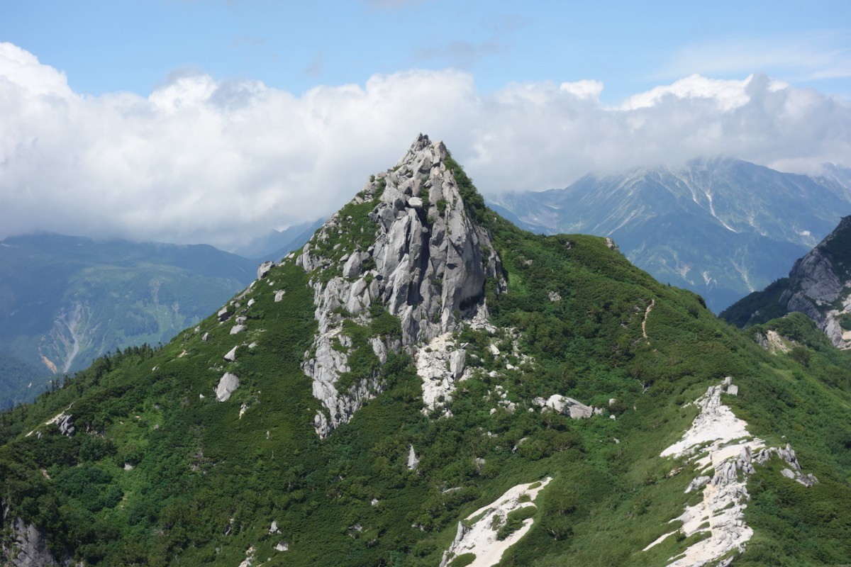
Mt. Eboshi (烏帽子岳, 2,628 m), on the border of Omachi in Nagano and Toyama City in Toyama, is one of the 200 Famous Japanese Mountains.
A sharp rocky peak standing at the start of the “Ura-Ginza” traverse in the Northern Alps, its appeal is the pointed, eboshi-hat summit and the cluster of tarns such as Eboshi-ike and Shijuhachi-ike scattered along the ridge. From the Takase Dam trailhead you climb the Bunatate Ridge, one of the three great steep climbs of the Northern Alps, and the classic plan is an advanced route staying one night at Eboshi Hut and going up to the summit and back.
For public transport to the trailhead, you combine the Ura-Ginza climbing bus from JR Shinano-Omachi Station to Nanakura and a special taxi from Nanakura to Takase Dam.
The trailhead is Takase Dam (about 1,270 m); the foot of the Bunatate Ridge is about 30 minutes’ walk away. The standard route is Takase Dam → Bunatate Ridge → Eboshi Hut (overnight) → Mt. Eboshi, out and back, with a total ascent time of about 5–6 hours. It is an advanced route with about 1,250 m of steep climbing at an average 23° grade that cannot be done as a day trip. The Bunatate Ridge has numbered markers about every 100 m, from “No. 12” at the trailhead to “No. 0” at Eboshi Hut.
On the ridge, Eboshi Hut is reservation-only and serves as a base for lodging, camping and emergencies. The best season is mid-July to the end of September, while the hut is open; on the ridge above the tree line, beware of strong wind, sudden weather changes and the rocky section from Mae-Eboshi to the summit. Always check the latest trail and hut-operation conditions in advance.
*Last checked: June 6, 2026
How to access the trailheads
1. [Round trip] Shinano-Omachi Station → Nanakura → Takase Dam (trailhead)
The base is Shinano-Omachi Station on the JR Oito Line. To Takase Dam you combine a summer-season climbing bus and a special taxi.
① Shinano-Omachi Station → Nanakura (Ura-Ginza climbing bus)
Take the “Ura-Ginza climbing bus” run by Omachi City and get off at Nanakura. Via Omachi Onsen-kyo and Kuzu Onsen it takes about 45 minutes, and the fare is ¥1,500 one way for adults (no reservation). It runs on designated days from 17 July to 25 October 2026, four round trips a day (with an early-morning service timed for the climb). Always check the operating days and times on the official calendar. Outside the bus period, take a taxi from Shinano-Omachi Station to Nanakura.
② Nanakura → Takase Dam (special taxi)
The road from Nanakura to Takase Dam is a power-station service road closed to general cars, so you use a special taxi (about ¥2,700 per regular car, about 15 minutes) or walk about 1 hour 30 minutes. In the peak season (July–August) it runs from 5 a.m. Mobile reception is poor around Takase Dam, so it is safer to book the return taxi in advance.
― Alpico Taxi, Omachi office 0261-23-2323
― Alps Daiichi Kotsu 0261-22-2121
Inquiries: For the latest bus and trail information, check with the Omachi City Tourism Association (0261-22-0190).
Source: [Ura-Ginza climbing bus (Omachi City)] / [Eboshi Hut access]
Route and safety notes
Route: Takase Dam → Fudo-sawa → Bunatate Ridge → Eboshi Hut → Mae-Eboshi → Mt. Eboshi (2,628 m). The total ascent time is about 5–6 hours, an advanced route with one night at Eboshi Hut. From the hut to the summit takes about 30 minutes, with a rocky climb just below the top.
Steep climb and rocks: The Bunatate Ridge is one of the three great steep climbs of the Northern Alps, a continuous 1,250 m ascent. The summit area from Mae-Eboshi to Mt. Eboshi is a rocky peak with chains, so beware of a fall in rain or strong wind.
Water, hut and season: There is no water source on the ridge, so buy drinking water at Eboshi Hut. The best season is mid-July to the end of September, while the hut is open; outside it, snow and ice make it unsuitable for general hiking. Eboshi Hut is reservation-only, so book in advance.
Gear and emergencies: Carry rain gear, warm clothing, a headlamp, a map/GPS, and ample water and food. In an accident or emergency, call 110 (police) or 119 (fire/rescue).
・Omachi Police Station 0261-22-0110
Photo by Koda6029 / Wikimedia Commons, CC BY-SA 4.0
Comments