Mt. Hiuchi (火打山, 2,462 m), in Myoko City, Niigata Prefecture, is one of the Kubiki Sanzan (Myoko, Hiuchi, Yakeyama) and the highest peak in Joshinetsu-kogen National Park, a 100 Famous Mountain of Japan (Kyūya Fukada’s selection).
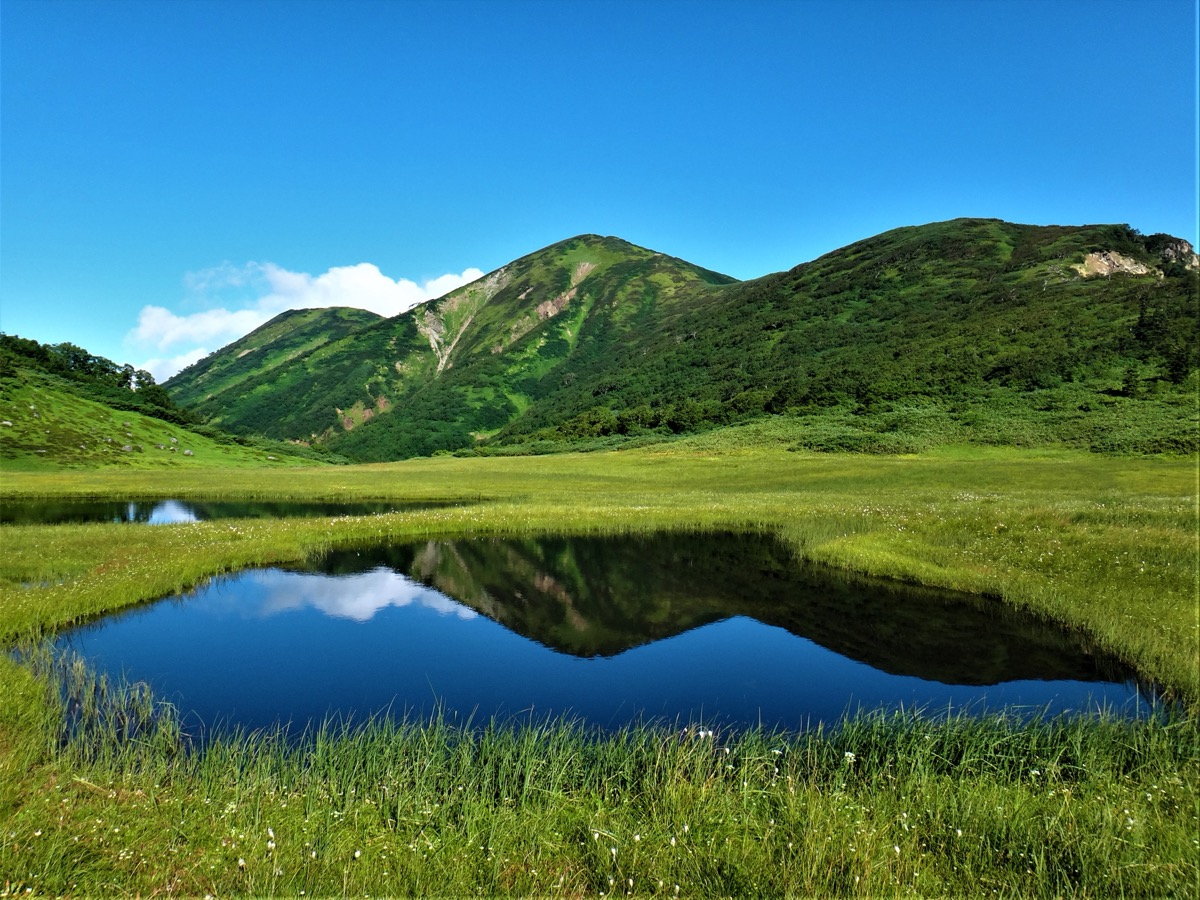
The highlights are Tengu-no-niwa (Tengu’s Garden) — a high-altitude wetland of tarns just below the summit — and the great alpine-flower fields of Hakusan-kozakura (July) and Hakusan-shakunage, plus the habitat of rock ptarmigan (the only place outside the Japanese Alps). The standard route is an out-and-back from Sasagamine trailhead via Kōyaike Hut (1,990 m); the 2-summit traverse with neighbouring Mt. Myoko (2,454 m, also a 100 Famous Mountain) is popular. Difficulty: intermediate ★★★, ~9–10 h (day-hike for fit hikers or 1-night 2-day plan recommended).
How to access the trailheads
- [Outbound] Tokyo / Osaka → Myoko-kogen Station (Hokuriku Shinkansen via Joetsu-myoko)
- [Round trip] Myoko-kogen Station ⇔ Sasagamine (Keinan Bus Sasagamine direct, summer-only)
- Trail overview, Kōyaike Hut, suggested plans
Standard times (Sasagamine course out-and-back, intermediate, ~9–10 hours)
Sasagamine trailhead (1,300 m) → (1:30) → Kurosawa Bridge → (1:00) → Jūni-magari → (1:00) → Fujimi-daira → (1:00) → Kōyaike Hut (1,990 m, recommended overnight) → (0:30) → Tengu-no-niwa → (1:00) → Raichō-daira → (0:30) → Mt. Hiuchi summit (2,462 m) → 4-hour descent → Sasagamine trailhead
1. [Outbound] Tokyo / Osaka → Myoko-kogen Station (Hokuriku Shinkansen via Joetsu-myoko)
The base for Mt. Hiuchi is Myoko-kogen Station (Echigo Tokimeki Railway Myoko Haneuma Line). From Tokyo Station, Hokuriku Shinkansen Kagayaki / Hakutaka reaches Joetsu-myoko Station in about 2 hours; the Myoko Haneuma Line then reaches Myoko-kogen in about 35 min. From Osaka, ~4 hours via Kyoto and Kanazawa. The Sasagamine direct bus (Section 2) departs from in front of Myoko-kogen Station.
JR and Shinkansen access guide :
Tokyo Station → Joetsu-myoko Station : Hokuriku Shinkansen Kagayaki / Hakutaka about 2 h, ¥10,650 (reserved)
Osaka Station → Joetsu-myoko Station : Thunderbird + Hakutaka about 4 h, ~¥18,200
Joetsu-myoko Station → Myoko-kogen Station : Echigo Tokimeki Myoko Haneuma Line about 35 min, ¥600
Reference : JR East | Myoko Tourism Bureau
Inquiries : JR Joetsu-myoko Station ☎025-523-0181 / Echigo Tokimeki Railway ☎025-543-8988
2. [Round trip] Myoko-kogen Station ⇔ Sasagamine (Keinan Bus Sasagamine direct, summer-only)
The only trailhead for Mt. Hiuchi, Sasagamine (1,300 m), is reached by Keinan Bus Sasagamine direct (Myoko-kogen Station → Imori-ike → Sasagamine-kogen) in about 50 min for ¥1,000 one way. Operates typically 12 July (mountain opening) – 26 October (2025 actual; 2026 to be confirmed), 2–8 runs per day depending on date. Sasagamine is the base for Mt. Hiuchi + Mt. Myoko traverse; parking (~150 spaces, free). Self-drive: ~17 km from Myoko-kogen IC.
Operating period : Typically 12 Jul – 26 Oct (mountain opening to autumn)
Travel time : Myoko-kogen Station → Sasagamine-kogen about 50 min
Fare : ¥1,000 (one way)
Frequency : 2–8 runs per day (varies by date)
Myoko-kogen Station → Sasagamine-kogen (Keinan Bus Sasagamine direct, summer-only, hiker excerpt)
| Myoko-kogen Station dep. | Imori-ike via | Sasagamine-kogen arr. |
|---|---|---|
| around 7:10 (early) | around 7:25 | around 8:00 |
| around 11:10 | around 11:25 | around 12:00 |
Sasagamine-kogen → Myoko-kogen Station (Keinan Bus Sasagamine direct, return, summer-only)
| Sasagamine-kogen dep. | Imori-ike via | Myoko-kogen Station arr. |
|---|---|---|
| around 13:20 | around 13:55 | around 14:10 |
| around 16:20 (last) | around 16:55 | around 17:10 |
Note : Operating periods and frequencies vary significantly — always confirm with Keinan Bus or Myoko Tourism. After the last bus (16:20), the only option is taxi (~¥10,000) to Myoko-kogen. Day-hiking requires the early bus (7:10); a ~10-hour round trip means a 17:00 descent, which won’t make the 16:20 last bus — one night at Kōyaike Hut is strongly recommended.
Reference : Niigata Tourism Sasagamine direct bus | Keinan Bus official
Inquiries : Keinan Bus ☎0255-72-3139 / Myoko Tourism Bureau ☎0255-86-3911
3. Trail overview, Kōyaike Hut, suggested plans
About Mt. Hiuchi
The highest peak (2,462 m) of the Kubiki massif in southwest Niigata, within Joshinetsu-kogen National Park, one of the Kubiki Sanzan (Myoko, Hiuchi, Yakeyama). The Tengu-no-niwa at 2,000 m is a high-altitude wetland of tarns — peak season for Hakusan-kozakura (July), Hakusan-shakunage (July), Chinguruma and Watasuge. Famous as the only rock-ptarmigan habitat outside the Japanese Alps and for its precious high-altitude wetlands. Selected by Fukada as one of his 100 Famous Mountains.
Trail summary (only 1 main course)
- Sasagamine course (intermediate, ~9–10 h + Kōyaike overnight recommended): Sasagamine trailhead → Kurosawa Bridge → Jūni-magari → Fujimi-daira → Kōyaike Hut → Tengu-no-niwa → Raichō-daira → summit out-and-back
- Traverse with Mt. Myoko (advanced, 2 nights): Sasagamine → Kōyaike overnight → Hiuchi → Kōyaike → Chausu-yama → Myoko → Tsubame Onsen (descent)
Kōyaike Hut (2026 information)
– 1,990 m, ~3–4 h walk from Sasagamine trailhead
– Open: typically Jun – Oct (dorm-only in May)
– Reservation: required, ☎0255-78-7588 (9:00–17:00, Jun–Oct) or via Mont-bell online store
– Fee: ~¥10,500/night with 2 meals, dorm ~¥6,500 (varies by year)
– Bedding: provided (bring sheet)
– Water: tap at the hut, busy at peak
– Toilet: yes; tent site available (¥1,500/person)
Climbing season / flowers: June – October. July: peak bloom of Hakusan-kozakura at Tengu-no-niwa (mid-July), plus Hakusan-shakunage. Late September to early October brings autumn colours (Chausu-yama to Tengu-no-niwa is spectacular). Residual snow until late June.
Cautions
– Effectively no day-hike: ~10 h standard; the 16:20 last bus is not realistic — one Kōyaike Hut night is recommended
– Tengu-no-niwa tarns and wetlands: stay strictly on boardwalks
– Ptarmigan breeding season (Jun–Jul): pass quietly
– Bear sightings: carry bells
Emergency contacts and inquiries
- Myoko City Tourism Section: ☎0255-74-0021 / Myoko Tourism Bureau: ☎0255-86-3911
- Myoko Police (climbing plan, mountain rescue): ☎0255-72-0110
- Keinan Bus: ☎0255-72-3139 / Kōyaike Hut: ☎0255-78-7588 (9–17)
Suggested plans
- One night, Kōyaike overnight, Hiuchi out-and-back (recommended): Day 1 Myoko-kogen 11:10 → Sasagamine 12:00 → Kōyaike Hut 16:00 → dinner. Day 2 early 5:00 → Tengu-no-niwa → summit 7:30 → descend Kōyaike 9:30 → Sasagamine 13:00 → bus 13:20 → Myoko-kogen 14:10
- Two nights, Hiuchi + Myoko traverse (recommended): Day 1 Sasagamine → Kōyaike → afternoon Mt. Hiuchi out-and-back. Day 2 Kōyaike → Chausu-yama → Mt. Myoko → return to Kōyaike or descend Tsubame Onsen. Day 3 Kōyaike → Sasagamine descent → Myoko-kogen
Reference : Myoko Tourism Mt. Hiuchi trail guide | Yama-to-Kogen Mt. Hiuchi autumn guide
Photo by Wikimedia Commons
Comments